The roads and routes constructed and developed by the Roman bound all manner of peoples together, made possible the intermingling of the most varies cultures, and raised the standard of living for every race through whose country they passed. Though perhaps to much credit is given to the Roman ad a road-maker, it is yet true that without his genius to perfect and unify the road-system as a whole communication between nations would have been much slower, much more difficult.
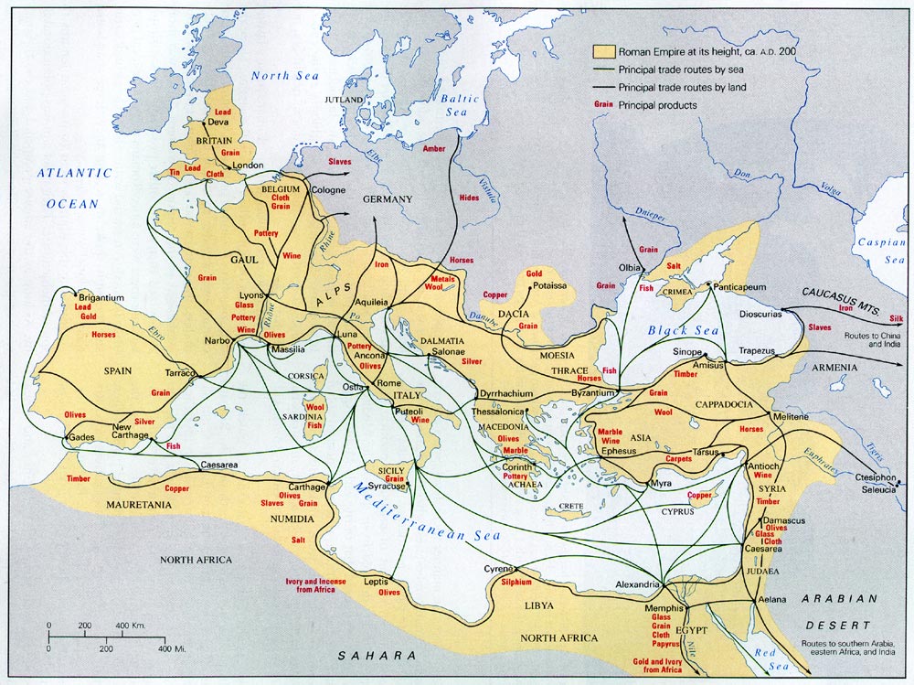
Roman trade routes and principal products in each region
The Roman, with his zest for road-building, brought into the world such far-reaching changes for the better, that modern man is yet benefiting from them.
The trade routes of Greece and of the continental territories Adjoining
Greece played a minor part as a trading country. Its importance lay in the fact that it was the link between and the East. Corinth and the Via Egnatia were vital parts of that link.
The province of Achaea was of little value to Rome. It’s products: oil, wine, honey, cloth, marble, horsed. The roads through the Peloponnesus were poor and often dangerous.
Corinth was restored by Julius Caesar a century after its destruction by Mummius. It was a thriving city, by reason of its position on a peninsula between two seas. A canal across the peninsula would have made no difference to the prosperity of Corinth or to the poverty of Greece.
Athens, in spite of Hadrian’s munificence, was by no means the brilliant center it once had been. Its harbor was almost deserted, and the goods it exported were few.
Greece’s main roads, outside of the Peloponnese, formed a rough triangle, with the northern Via Egnatia as one of the three sides. On the western side of the triangle were Nicopolis, Apollonia, and Dyrrhachium, regular ports of call for ships from Italy.
The Via Egnatia moved from Apollonia and Dyrrhachium eastward toward Byzantium. Travelers would often break their journey along with it at Neapolis, and they take a ship to Asia Minor.
Profitable mines existed in Macedonia (in the region of Philippi) and in Dacia. The Highway to Dacia from Greece branched off Via Egnatia at Thessalonica.
Byzantium was a city of great commercial and military importance. A free and confederate city until 73 A.D., it was then made a part of Thrace by Vespasian.
Trade routes of Asia Minor
Asia Minor was acquired by Rome in the years between 129 B.C. and 63 A.D.
Three main west-east highways followed the paths laid down by nature. They were:
The Southe Road (Ephesus – Magnesia – up the Maeander Valley to Laodicea on the tributary Lycus – Apamea – Pisidian Antioch – Iconium – Tyana – Tarsus)
The Central Road (Sarids – up the valley of the Hermus – northward to Ancyra – Melitene on the Euphrates. Late the route had its western terminus at Ephesus instead of at Sardis.
The Northern Road (Nicomedia – Claudiopolis – Cratea – Amasea – Comana – Nicopilis – Satala – then into Armenia. An important branch, southward from Nicomedia to Ancyra.
The southern road was of greatest importance as a commercial highway, the northern road as a military highway. The central road was the least important of the three.
The outstanding north-south highway joined Simope and Amisus on the Black Sea to Tarsus.
The chief cities of Asia Minor:
Ephesus (“the largest mart in Asia within the Taurus)
Tarsus (had commercial relations with every city in the world. Splendid harbor in Lake Rhegma)
Nicomedia (leading city of Asia Minor under Diocletian)
Leading products: wine, fish, fruits, timber, wool (and the secondary products thereof), marble, and some metals, particularly copper.
Reorganization of all the roads took place under Domitian. The Flavian emperors were interested in the northern roads for military reasons, and their interest was continued by Nerva and his successors.
There was heavy traffic along the sea coasts, particularly on the western coast, where Cyzicus, Mytilene, Chics, Smyrna, Ephesus, Miletus, and Rhodes were situated.
The silk roads to China
Roman interest in silk and the silk roads began about the time of Augustus. By Tiberius’ reign, the use of silk was well established among the wealthier classes.
Exploration of the first silk road to China began in earnest after 20 B.C. Greek explorers, working for Augustus, reached Kandahar, as did Isidore of Charax. The agents of Maes Titianus continued the exploration (c 120 A.D.) and reached some point a few miles beyond Kashgar. Later years saw western travelers even in Lop Nor and Miran.
The first silk road in detail: Zeugma – Seleucia and Ctesiphon – across the Zagros Mountains to the Caspian Gates – Hecatompylos – Merv – (then by either of these roads: [- Samarcand – Kashgar – Miran – Lop Nor] or [Bactra – Stone Tower – Kashgar – Miran – Lop Nor]).
Seleucia and Ctesiphon enjoyed great commercial advantages because of their fortunate position on the trade routes. Seleucia was the greater of the two foundations.
Bactra had been a great trade center for centuries before it had any contact with the Roman Empire. To visualize its position in Asia, imagine it as the hub of a wheel, from which the road to Parthia, the Oxus River, the Valley of the Indus, and the highway to China radiated, like the spokes of the wheel.
The Romans never became properly acquainted with the Chinese. Some effort was made by the Chinese to gather information about the West in 97 A.D. when they dispatched an ambassador to Parthia and Syria.
The second overland route to China was developed because of the need for avoiding the Parthians. Its course lay from the coast of Asia Minor to Phasis – to the Cyrus (note parallel valleys) – the Caspian – the Oxus – Samarcand or Bactra.
Exploration of the land up to and surrounding the Caspian Sea was complete by 150 A.D. The lands east and north of the Jaxates were not explored in the time of the Roman Empire.
Silkworms were brought from China to Constantinople in the sixth century A.D. All future European and western Asiatic silkworms were descended from these.
Trade routes of Syria
Syria’s commercial importance was due to its position, not to its resources. The country was the “Gateway to East”.
The road-system was complete long before the Roman occupation. Perhaps more than in any other country except Asia Minor, the highways controlled in their direction by the nature of the terrain.
The three great north-south highways were:
The coast road from Gaza to Seleucia Pieria and Antioch.
The road which left the coast at Caesarea and pursued the valleys of the Upper Jordan, Litas and Orontes.
The Petra-Damascus-Palmyra-Euphrates road
At Petra, Palmyra and Antioch began routes connecting Syria with Arabia and the Far East.
An Abundance of native materials made road-laying easy. Trajan and Diocletian added many improvements to the highways.
Syria’s leading harbors were: Caesarea, Tyre, Sidon, Berytus, Aradus, Laodicea, Seleucia. Tyre and Sidon were renowned for their dyed stuff and their glass.
Syria’s leading cities were – Antioch, Damascus, Palmyra, and Petra. The last two were brought under Roman control in the reign of Trajan.
The Egyptian trade routes
The greatest traffic lane in Egypt was the Nile. Alexandria, Egypt’s first cite, was also the foremost market of the world.
The Quantity of grain Egypt could produce, as well as the incompetence of its late rulers, brought the country into Roman hands.
Traffic along the Nile halted on the south at Syene. Aethiopian goods could be carried overland but were brought north more easily by the Red Sea.
Nile boats were of varied and unusual types. For heavy loads, the baris were used.
Canals took the place of roads on the Delts.
The Egyptians improved in every possible manner the connections between the Nile and the Read Sea, in order to induce traffic to leave the Persian Gulf-Euphrates route for their own Red Sea – Nile route.
The River of Ptolemaeus (Trajan’s River) was of minor importance due to the fact that its eastern terminus was at the head of the treacherous Red Sea waters.
Camels were common as transport animals only in the Roman period and were of no great advantage to merchants.
Alexandria’s site was unparalleled in its advantages. Of the city’s three fine harbors, that on Lake Mareotis was the most thriving.
Articles manufactured in Alexandria for export including paper, glass, woolen goods, linen, and ointments. The Egyptian city was an exception to the rule that all the wealthy cities of the world had won their prosperity from the transport trade.
Vessels sailing between Alexandria and Rome were extremely large for their time. Grin ships were particularly well-built, well-manned, and well-guarded.
The season for sailing the Mediterranean was from March 10 to November 10. Until mid-July, ships might sail westward to Italy from Alexandria; after that time they followed a course which brought them first to Asia Minor and then to Italy. The normal time for a summer voyage was 18 – 20 days; for a winter voyage, 40 days were required.
The sea routes to India and Ceylon
Ships plying between India and the West were restricted, in the early years of the Empire, to following the shores of Arabia and Persia. Therefore middlemen waxed prosperous at the expense of both eastern and western trades passing along their shores.
Steps were taken in the acquisition of a Roman trade route to the east:
under Augustus – attempts made to attack Aden (Aelius Gallus and prince Gaius)
under Claudius – a sack of Aden.
under Nero – an occupation of Cape Syagrus.
Development of route directly across the seas between the Gulf of Aden and India.
Hippalus’ voyage from Aden – Indus.
under Claudius, a voyage from Cape Syarus-Jaigarh.
later, a voyage from Aden – Muziris. (Nalcynda or Barake better points at which to disembark).
Continuance of coastal traffic between India and the West. The best description of a coastal voyage to India found in the Periplus Mari Erythraei.
Time required for voyage between Tamil coast and Rome – 16 weeks (Rome to Alexandria – 3 weeks, Alexandria to Red Sea Ports – Egyptian or Nabataean Ports to Okelis – 4 weeks, Gulf of Aden to Muziris – 6 weeks.
Little was known of Ceylon in the Roman period since Tamils held a monopoly of trade with the island for many years.
Exploration of the eastern coast of India was carried on mainly in the second century A.D. Some weatern ships reached China, but sea trade with that country did not develop.
The Declinee of trade with India in the third century is mirrored by a lack of third-century Roman coins in the country. First and Second century Roman coins reveal that trade was directed first to southern India, the pearl and spice region, then to northern India, the cotton region.


hi can Trump die yet?