USA Population in Hexagons
The spatial distribution of population within the United States is a fascinating study that reveals patterns influenced by a multitude of factors, including historical events, economic opportunities, geographic features, and social dynamics. One striking feature is the concentration of population along the coasts, particularly the eastern seaboard and the western states bordering the Pacific Ocean. Major metropolitan areas such as New York City, Los Angeles, and San Francisco attract large numbers of residents due to their economic vibrancy, cultural diversity, and employment opportunities.
However, within these coastal regions, there are significant variations in population density. For instance, the Northeast Corridor, stretching from Boston to Washington, D.C., forms one of the most densely populated regions in the country, with urban centers tightly packed together.

On the other hand, the Pacific Northwest exhibits a more scattered distribution of population, with cities like Seattle and Portland surrounded by vast expanses of forests and mountains.
In contrast to the densely populated coastal areas, the interior of the country, particularly the Great Plains and Rocky Mountain regions, experiences lower population densities. Factors such as harsh climate, limited water resources, and sparse infrastructure contribute to the relative sparsity of inhabitants in these areas. However, there are exceptions, such as major cities like Denver and Dallas, which serve as economic hubs for their respective regions and draw significant populations despite their inland locations.
Furthermore, historical trends have shaped the distribution of population within the United States. The legacy of westward expansion, driven by factors such as the Homestead Act and the lure of new opportunities, led to the settlement of vast stretches of land in the Midwest and the Sun Belt. Today, these regions continue to experience population growth, driven in part by migration from other parts of the country, seeking affordable housing, favorable climates, and job prospects in industries like technology, healthcare, and manufacturing.

Cartographer Hilário de Sousa has crafted a remarkable map of the United States, delineating the 111 largest Metropolitan Statistical Areas (MSAs) with colored groups of hexagons. Each colored hexagon represents a population of 500,000 inhabitants. Additionally, small MSAs are denoted by gray hexagons with a bold gray border, while MSAs with a population of 100,000 people are represented by gray hexagons without a bold border.
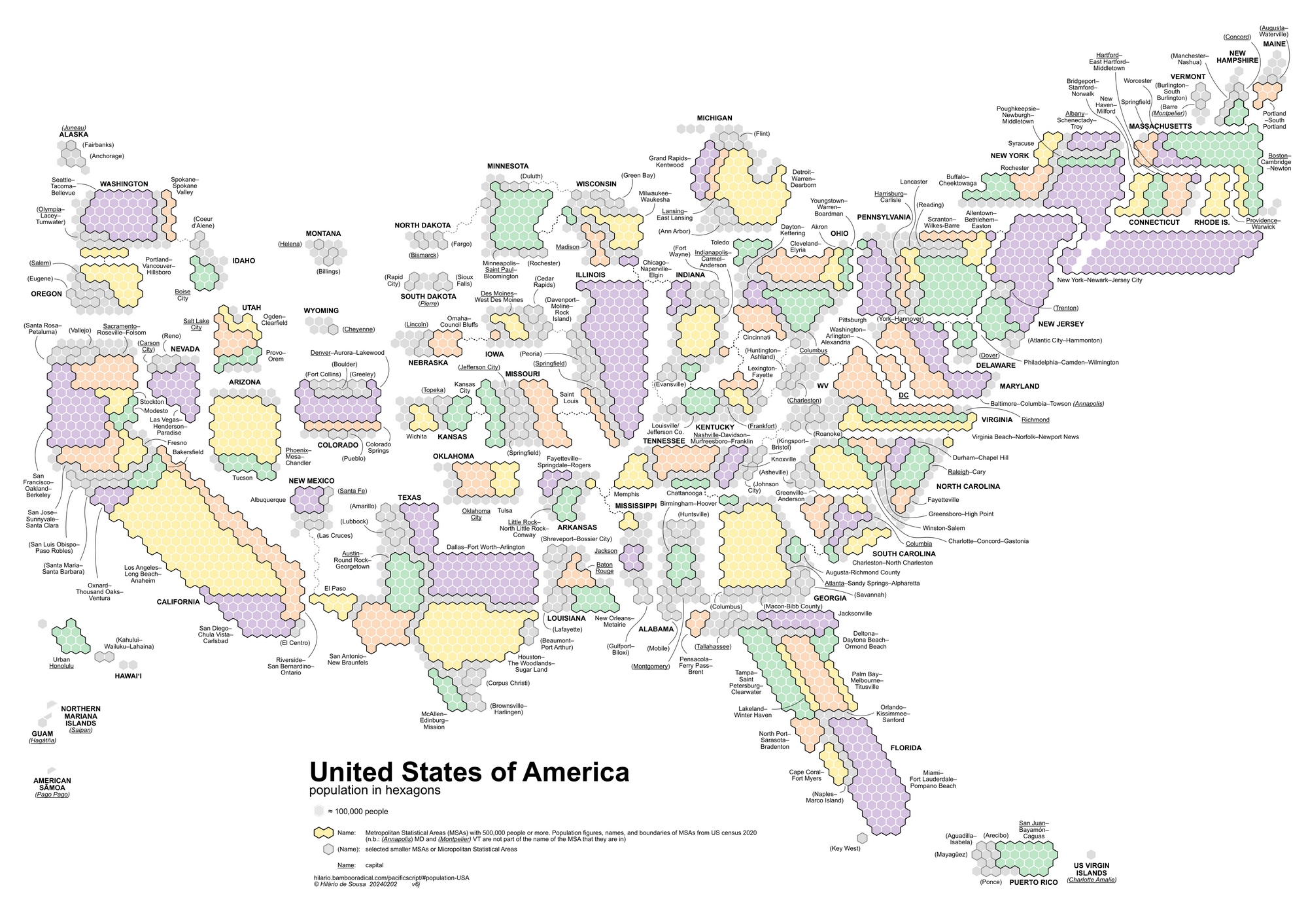
This map clearly illustrates the largest American Metropolitan Statistical Areas (MSAs), which are the most populous and economically significant regions in the country. At the top of the list is the New York-Newark-Jersey City MSA, which boasts a staggering population exceeding 20 million residents.
Top 10 largest American Metropolitan Statistical Areas (MSAs)
| Rank | Metropolitan Statistical Area | Population | Description |
|---|---|---|---|
| 1 | New York-Newark-Jersey City, NY-NJ-PA | Over 20 million | The largest urban area in the U.S. and a global financial center, with iconic landmarks like Times Square and Wall Street. |
| 2 | Los Angeles-Long Beach-Anaheim, CA | Over 13 million | The entertainment capital of the world, it’s home to Hollywood, major film studios, and diverse cultural attractions. |
| 3 | Chicago-Naperville-Elgin, IL-IN-WI | Over 9.5 million | A major transportation hub, Chicago is famed for its architecture, blues music, and deep-dish pizza. |
| 4 | Dallas-Fort Worth-Arlington, TX | Over 7.6 million | A leading business and technology hub, home to several Fortune 500 companies and the Dallas Arts District. |
| 5 | Houston-The Woodlands-Sugar Land, TX | Over 7.1 million | A global energy capital, housing the headquarters of many oil and gas companies, and boasts a thriving culinary scene. |
| 6 | Washington-Arlington-Alexandria, DC-VA-MD-WV | Over 6.3 million | Besides being the nation’s capital, the region hosts numerous museums, government agencies, and tech companies. |
| 7 | Miami-Fort Lauderdale-West Palm Beach, FL | Over 6.1 million | Known for its vibrant nightlife, beautiful beaches, and diverse cultural influences, Miami is a major tourist destination. |
| 8 | Philadelphia-Camden-Wilmington, PA-NJ-DE-MD | Over 6 million | Philadelphia played a crucial role in American history and is famous for its cheesesteaks, art museums, and historic sites. |
| 9 | Atlanta-Sandy Springs-Alpharetta, GA | Over 5.9 million | Atlanta is a center for finance, media, and higher education, with attractions like the World of Coca-Cola and the Georgia Aquarium. |
| 10 | Boston-Cambridge-Newton, MA-NH | Over 4.9 million | Boston is known for its prestigious universities, historic landmarks like the Freedom Trail, and the thriving biotech industry. |
Are you in search of a map of the United States for your home or office? We recommend that you take a look at these maps.


