Why 87% of Australians Live on a Thin Coastal Strip
Australia and the continental United States cover roughly the same area (Australia: 7.7 million km² / about 3 million sq mi; the continental U.S.: 8.08 million km² / 3.12 million sq mi), but the US has 335 million people and Australia has 27.7 million. As a result, population density in the US is about 36 per km² (13.9 per sq mi) while in Australia it is 3.6 per km² (9.3 per sq mi).
On top of that, Australia’s population is unevenly distributed because about 70% of the continent is arid or semi-arid and not well suited for large settlements. The maps below clearly show this.

The first European settlements were port cities, and the population mostly stayed near them. By 2019, 87% of Australians lived within 50 km (31 mi) of the coastline, a figure that had been creeping up since at least 2001, when it was 85%.
Today, the population is concentrated in a dense arc from Brisbane through Sydney and Melbourne down to Adelaide, with a separate cluster around Perth on the western edge. Perth is 2,700 km (1,677 mi) from Sydney by road, closer to Singapore than to the east coast. Western Australia covers about a third of the country but has only 3 million people.
| State / Territory | Population (Dec 2024) | Annual Growth |
|---|---|---|
| New South Wales | 8,545,100 | +1.3% |
| Victoria | 7,011,100 | +1.9% |
| Queensland | 5,618,800 | +1.9% |
| Western Australia | 3,008,700 | +2.4% |
| South Australia | 1,891,700 | +1.1% |
| Australian Capital Territory | 481,700 | +1.4% |
| Tasmania | 575,800 | +0.3% |
| Northern Territory | 262,200 | +1.2% |
| Australia | 27,400,000 | +1.7% |
Tasmania has roughly the size of Ireland, with decent rainfall and good agricultural land across much of the south, yet it has just 575,800 residents, fewer than inner Brisbane.
Over the past decade, net overseas migration has contributed roughly 60% of Australia’s total population. In 2024-25, that meant 258,100 of the 324,700 people added to capital cities were overseas arrivals, and the vast majority went to Sydney, Melbourne, Brisbane, and Perth, not anywhere inland.
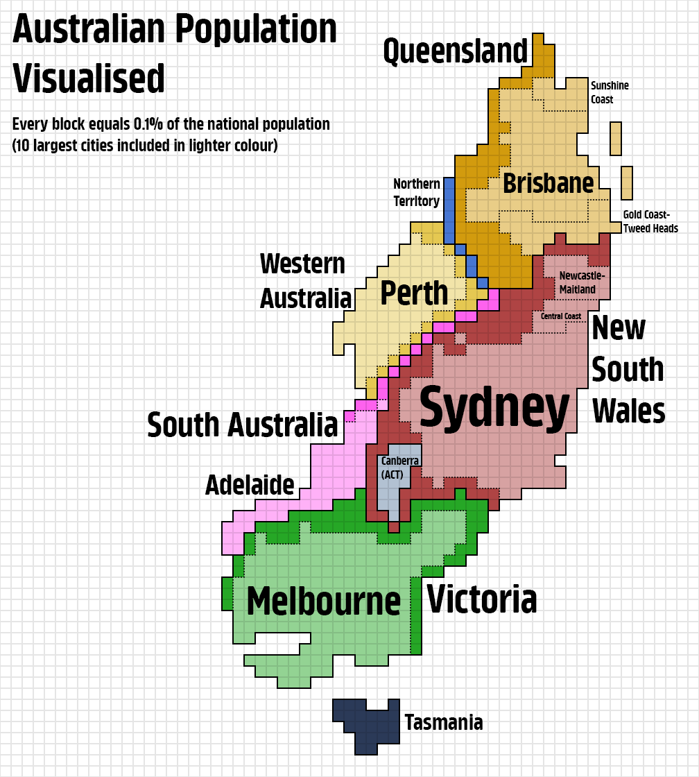
Reddit user KaleyTheKing made the cartogram below, with each block equalling 0.1% of the national population and Australia’s 10 largest cities shown in lighter colour.
Melbourne added 105,000 people in 2024-25, more than any other Australian city that year, and it has been outgrowing Sydney for a while. The Centre for Population’s 2024 Statement projects that Greater Sydney will reach roughly 5.9 million people by 2030-31, retaining its title as the nation’s biggest city over Melbourne’s revised forecast of 5.8 million at that point. Because federal forecasts pushed Melbourne’s overtaking timeline well into the late 2030s, Sydney stays number one, meaning the last time Melbourne was officially Australia’s largest capital city was during the 19th-century Gold Rush.
For those interested in exploring Australia’s geography further, here are some map resources available on Amazon:


Yikes! the cartogram on the right looks like some kind of poisonous insect (appropriate for Australia, come to think of it).