At first glance, it might seem that human activity is relatively insignificant compared to high mountain ranges and vast oceans when viewing the globe from space.
But if you look closely, human activity has become so all-encompassing that it can be seen on any continent on Earth. The most exciting fact is that even political borders can be discerned from space, as each country has its specific land-use features.
The images below taken by astronauts and orbiting satellites show Earth’s surface, where international boundaries can be seen.
The map below shows the Amur River dividing the uninhabited far east of Russia from China’s deforested and densely populated lands.
China – Kazakhstan
The image created by NASA shows northwestern China nearby the city of Qoqek and the far eastern part of Kazakhstan near Lake Balqash.
Land-use policies define the boundary between the two nations. In China, land use is intense. About 11.62% of China’s land is arable. Driven by a need to provide food for 1.3 billion people, China farms just about any land suitable for agriculture. On the satellite image below, dark-green fields contrast the surrounding arid landscape, indicating irrigating agriculture.
While just 0.03 percent of Kazakhstan’s land is dedicated to permanent agriculture, it represents a tiny part of its economy. The nation has a few Post-Soviet industrial-sized farms dotted throughout on this map, but the land along the border with China is barely used.
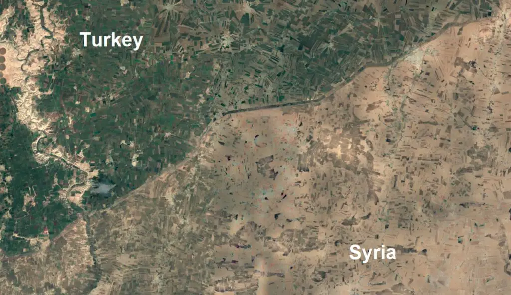
Turkey – Syria
The territory of Turkey bordering Syria is home to many farms, which function thanks to relatively well-developed infrastructure and irrigation systems.
Brazil – Bolivia
The river, which outlines the border between northwestern Brazil State of Acre (upper left) and Pando Department in the north of Bolivia (lower right), represents a remarkable difference in land use and development methods. Brazil has cut down the rain forests here for agriculture and settlements. In contrast, Bolivia has kept its forests intact. The image was taken with the Earth-observing instrument Advanced Spaceborne Thermal Emission and Reflection Radiometer (ASTER).
Argentina – Brazil – Paraguay
Argentinian deep green territory covered with woods contrasting with surrounding heavily populated parts of Brazil and Paraguay occupied with farmlands.
Belize – Guatemala
Deforestation differences between Belize and Guatemala form a straight line along their borders noticeable from space.
Guatemala has witnessed some of the highest deforestation rates in the Americas, caused mainly by converting forests into cropland and stocks pastures. From 2001 to 2019, Guatemala lost 1.48 million hectares of tree cover, equal to a 19 percent drop in tree cover after 2000.
Israel – Egypt
Below, the cosmonaut photo shows noticeable borderline marks about 50 kilometers (31 miles) of Egypt and Israel’s international border.
The contrasting colors of the land surface result from trampling by people and their cattle. Trampling disrupts the dark-colored soil crusts on the Egyptian part of the border, providing lighter-colored dune sand beneath the crusts to be opened by winds. A road also follows the boundary, making the differentiation more noticeable.
On the north side, Israel has a lot of circle-shaped fields with crops, while bordering Egypt’s landscape is emptier.
South Korea – North Korea
The most noticeable differences between North Korea and South Korea from space can be seen at night. Due to poor infrastructure and street lighting, North Korea looks like a single black spot from space at night.
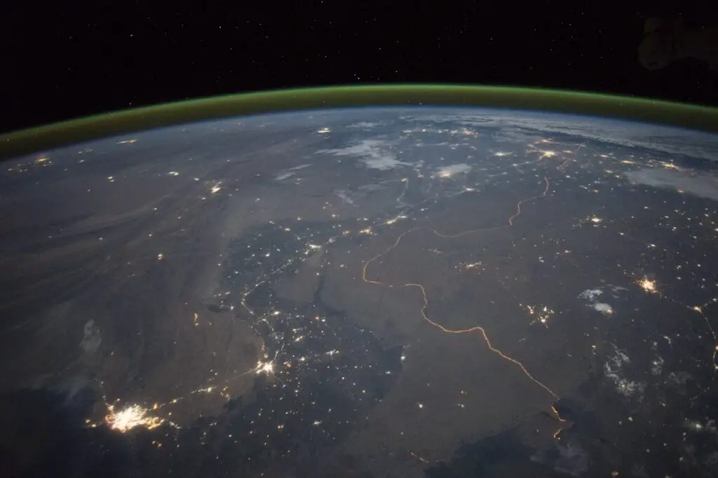
Pakistan – India
The Pakistan-India border can be seen from space thanks to the 3323 kilometers (2,065 miles) long security lights all along the border.
Known as the Radcliffe Line, the border is one of the most densely militarised globally and has a fence going its whole distance to control smuggling and firearms trafficking. Thousands of soldiers are constantly on duty along the border.
United States – Mexico
The image below was taken by the Earth-observing instrument ASTER of the Terra satellite.
It features the contrast in the landscape within the United States and Mexico. On the north is the United States covered in rich farmland (red color), while on the south, the empty areas of land in Mexico are punctuated with agricultural fields.
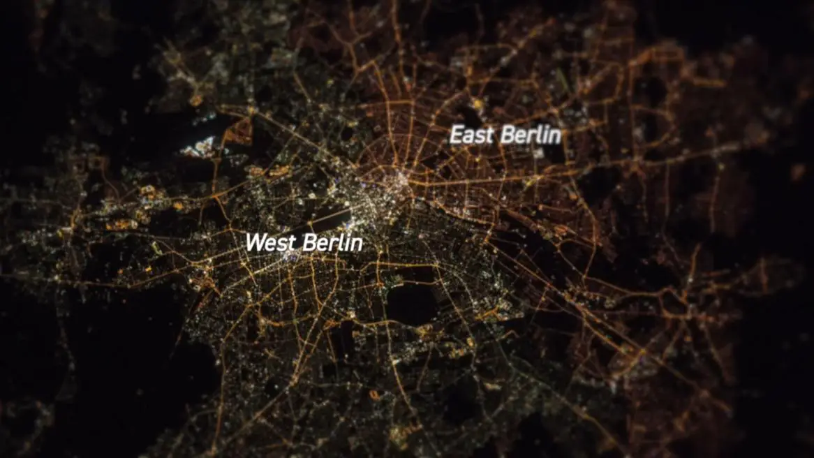
East and West Germany
The economic activities of neighboring countries can be so different that the state border between the two countries can be seen from space even after many decades after the unification.
The most striking example is Germany. The border between East and West Germany can be seen from space, even though 30 years have passed since they were united.
On the satellite image below, you can see the differences between East and West Berlin. East Berlin used yellow sodium lights instead of mercury vapor or metal halide lights like in West Berlin, and old electrical systems are possibly not electrically compatible.