The Brexit Vote Mapped as an Archipelago
Few political votes in recent British history produced as much debate as the Brexit referendum. On 23 June 2016, voters across the United Kingdom and Gibraltar were asked whether the country should remain in or leave the European Union. When counting finished the following morning, 51.89% had voted Leave and 48.11% had voted Remain, a margin of 1,269,501 votes. Turnout was 72.2%, the highest for any UK-wide vote since the 1992 general election.
That national margin, though, masked some very deep regional splits. Scotland backed Remain by 62%, and not one of its 32 council areas returned a Leave majority. Northern Ireland voted 55.8% Remain. London was the only region in England where Remain won, with 28 out of 33 London boroughs backing it. England overall went 53.4% Leave, Wales returned 52.5% Leave, and the West Midlands recorded the highest Leave share of any English region at 59.3%.
| Nation / Region | Remain % | Leave % | Turnout |
|---|---|---|---|
| Scotland | 62.0% | 38.0% | ~67% |
| Northern Ireland | 55.8% | 44.2% | 62.7% |
| Greater London | ~59.9% | ~40.1% | ~69.7% |
| England (overall) | 46.6% | 53.4% | ~73% |
| Wales | 47.5% | 52.5% | ~71.7% |
| Gibraltar | ~95.9% | ~4.1% | ~84% |
| UK + Gibraltar total | 48.1% | 51.9% | 72.2% |
Mapping the Vote as an Archipelago
The maps below were created by ESRI UK on the same principle I used for my TrumpLand vs. Biden Archipelago map a few years back. Remain-voting areas become land, Leave-voting areas become sea.
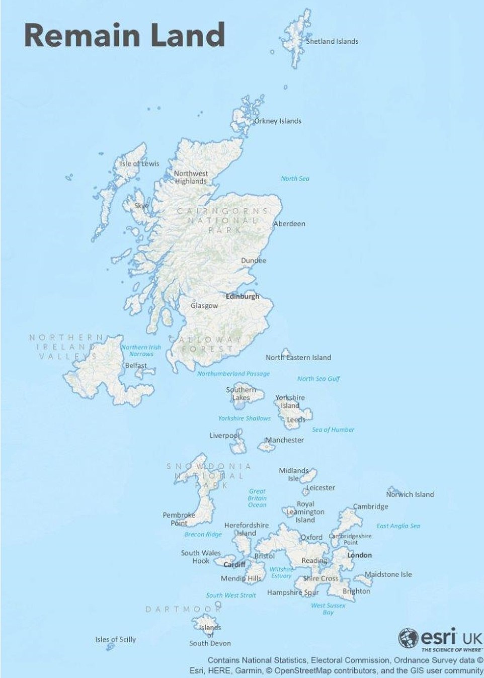
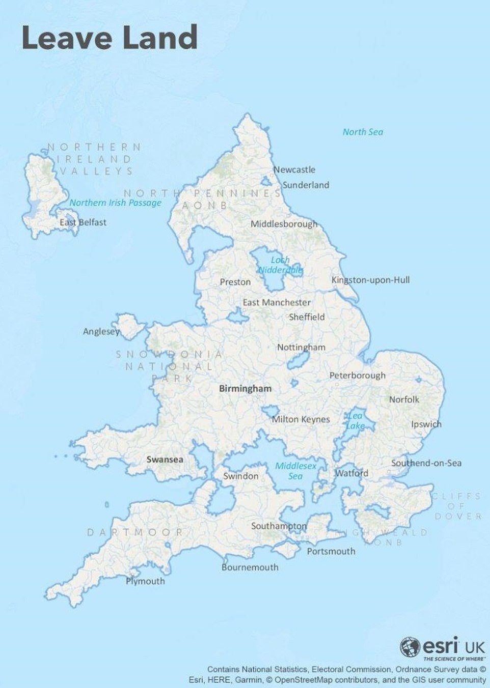
The result reshapes the UK into a scattered archipelago. Scotland and Northern Ireland become two large island groups. Inner London is a solid landmass. Much of rural England and coastal Wales disappears below the waterline.
A Physical Map of “Remain Land”
DeviantArt user stagyika pushed this concept further by creating a satellite-style physical map that removes all Leave-voting areas entirely, showing only the Remain-voting regions as they would appear from space.

What remains is a fragmented country of disconnected islands, mostly Scotland, Northern Ireland, London, and a handful of university cities like Manchester, Liverpool, Leeds, and Newcastle, all separated by vast stretches of Leave-voting territory now rendered as open ocean.
The maps above do not explain the politics behind it. The following books and documentary are available on Amazon.
- All Out War: The Full Story of How Brexit Sank Britain’s Political Class (Book)
- Brexit Through the Non-Political Glass (Prime Video)
- Heroic Failure: Brexit and the Politics of Pain (Book)


