Coastlines of the Ice Age
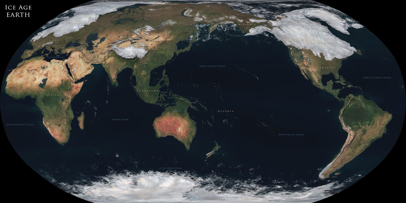
The ice age is a long period of decrease in our planet’s surface and atmosphere temperature, resulting in the growth of continental and polar ice sheets and mountain glaciers. During the last ice age, about one-third of the Earth’s surface was covered by ice.


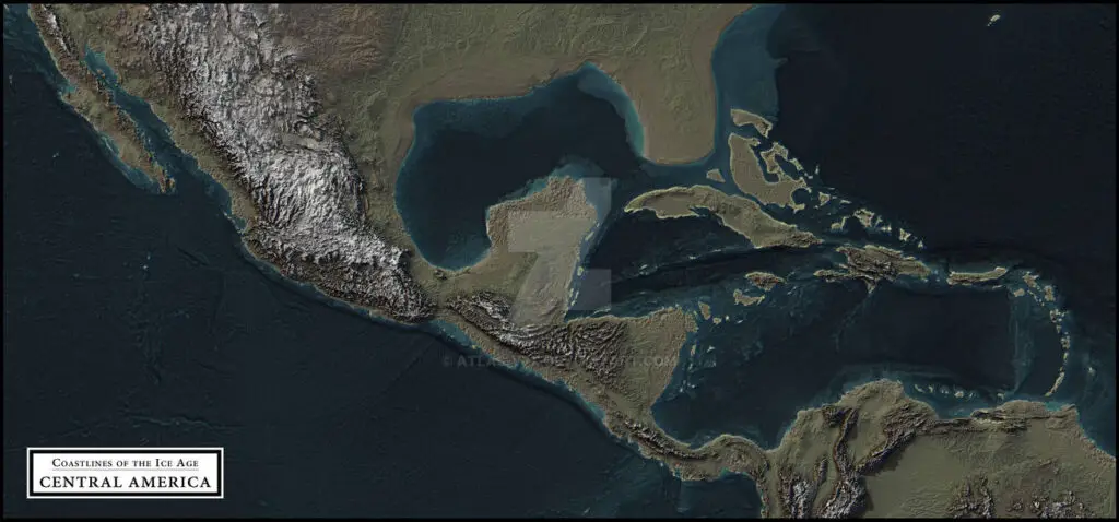
The maps below created by atlas-v7x show how the territory may have arisen during the Last Glacial Maximum, around 21 thousand years ago, when sea levels were about 125 meters (410 feet) below the present. These maps don’t contain any lakes of this period. The coloring of maps is based only on altitude. These maps have lines running in various directions over the landscape that arise as ranges or trenches.
Europe

Siberia at the height of the last ice age

East Asia

Southeastern Asia (Sundaland)

Australia (Sahul)

Central America


So much of human history has never been discovered because it is under water.
Why would Siberia, which is frigid to begin with, not be covered by an ice sheet? What about the Azores in the middle of the Atlantic? Wouldn’t the weight of the ice over N. America and Europe cause the ocean to bulge up and expose even more land than expected by a 400 foot drop in sea level? I think the “myth” of Atlantis needs to be revisited. There’s so much we don’t about history. Mankind didn’t suddenly crop up ten thousand years ago. I think we’ve been around for millions of years and survived several ice ages.
not survived several ice ages but survived several dramatic climatic events that either interrupted ice ages or ended them.
ps: these maps with 400 meters of water lower are missing the island groups from the strait of Gibraltar to the middle of the atlantic ocean that had their landmasses raised from their current 2 to 3.5 mile depth below the sea level(we know they were above because we found beach sand, sea shells and other evidence of aquatic life that only exists in shorelines back in 1948 to 52 in some expeditions with a ship called…Atlantis, although they had no notion of discovering it), the middle having this giant plateau that is large enough to be Atlantis and with its mountain ranges and location fits Plato’s description, it also as I said had really big islands(present day islands under the control of Portugal that are actually the tops of mountains of much bigger islands back then) to the east, meaning jumping points from island group to island group from present day Spain to this plateau called the Azores Plateau.
Most of Siberia and central Alaska were both too dry to be glaciated. They just didn’t get much precipitation because of the winds getting messed up and most of the surrounding waters being covered by sea ice,
During the Ice-age all the water froze out of the air long before it reached Siberia.
Siberia was probably covered in ice, historians just want to promote the myth of an Asia and North America land bridge. What person in their right mind would want to trek over 1,000 of miles of ice, with crevices and not knowing if there would be food sources?
Most likely 1st nation people arrive via boat from Africa/Northern Europe or Southeast Asian islands.
“Most likely 1st nation people arrive via boat from Africa/Northern Europe or Southeast Asian islands.” I was once interested in this hypothesis; however, DNA evidence has discounted it. Have a look at this book–it’s quite good: Who We Are and How We Got Here: Ancient DNA and the New Science of the Human Past, by David Reich
Very Good.
Would be great to have one that shows both Sundaland and Sahul on the same map in detail. Great for explaining the Wallace Line, Lydekker Line and Wallacea eco-region.
Always credit the source when you use other people’s work:
deviantart.com/atlas-v7x
Seems all the ice stacked up in the north would make the earth out of balance. That land should bulge up around the equator to make the Earth round. I propose that this map under-represents the amount of land because of unrecognized iso-static effects. Th
The maps are very good, but South America is missing.
So is North America.. Wonder why ?
would be good to see each image alongside its present equivalent to really assess the impact.
Excellent work. Thank you very much. Is it possible to superimpose today’s coordinates on these maps?
One more thing. How big was New Zealand during the last Ice Age?
There shouldn’t be big lakes in the Sahara during the LGM. It would be much drier
I’d like to know how these maps were obtained. I have looked hard for such Ice Age coastline maps but failed to find any.