Geography Facts About the U.S. Counties
In the United States, a county is an administrative and political subdivision of U.S. states. The United States Census Bureau uses county equivalent to represent places similar to counties but called various names (parishes in Louisiana, boroughs in Alaska).
The specific governmental powers of counties vary widely between the states. Counties have significant functions in all states except Rhode Island and Connecticut, where county governments have been abolished, but the entities remain administrative or statistical.
There are nowadays 3,143 counties and county-equivalents in the 50 U.S. states and D.C. The quantity of U.S. counties per state varies from the three counties of Delaware to the 254 counties of Texas.
Table of Contents
The History of U.S Counties
The first U.S. county (James City in Virginia) was founded in 1634. The map below shows when was each U.S. county and county-equivalents created.

Some established counties haven’t existed long. For example, Bullfrog County in Nevada was founded in 1987 and abolished just two years later. The latest U.S. county, Broomfield Country, was organized in Colorado in 2001.
The animated map below shows the territorial evolution of U.S. counties and their borders.
Largest and smallest counties by land area
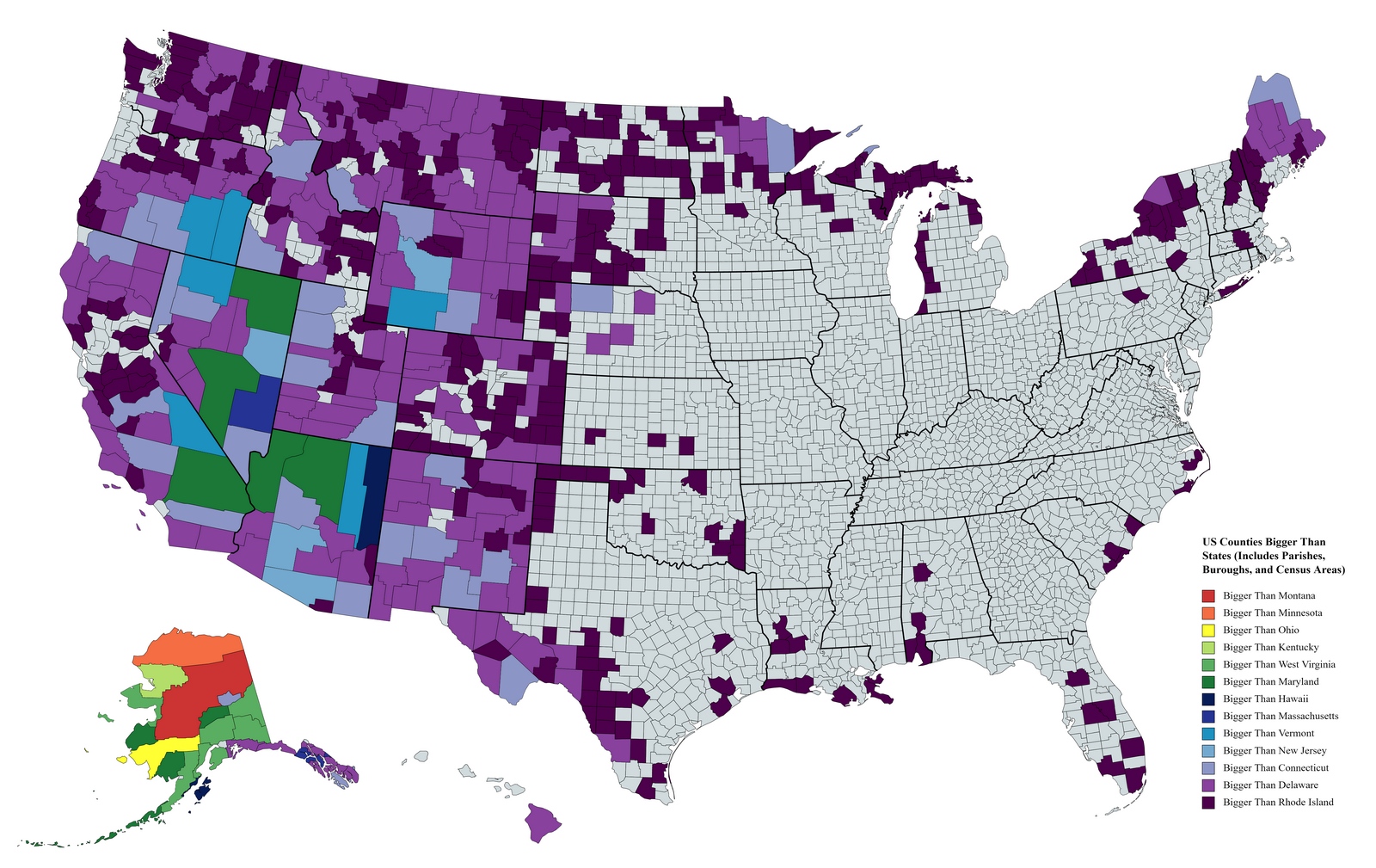
The state’s largest county-equivalent by area is the Yukon–Koyukuk Census Area (145.50 thousand sq mi or 376.86 thousand sq km). It is the only administrative or political subdivision that is larger than the entire state of Montana.
The map below shows U.S. Counties Bigger than States.
Largest counties and county-equivalents by land area
| Rank | County | State | Area (sq mi) | Area (sq km) |
|---|---|---|---|---|
| 1 | Yukon-Koyukuk | Alaska | 145,899.69 | 377,868.50 |
| 2 | North Slope | Alaska | 88,817.12 | 230,035.30 |
| 3 | Bethel | Alaska | 40,633.31 | 105,239.80 |
| 4 | Northwest Arctic | Alaska | 35,898.34 | 92,976.30 |
| 5 | Valdez-Cordova | Alaska | 34,319.10 | 88,886 |
| 6 | Southeast Fairbanks | Alaska | 24,814.86 | 64,270.20 |
| 7 | Matanuska-Susitna | Alaska | 24,681.54 | 63,924.90 |
| 8 | Lake and Peninsula | Alaska | 23,781.96 | 61,595.0 0 |
| 9 | Nome | Alaska | 23,000.91 | 59,572 |
| 10 | San Bernardino | California | 20,052.5 | 51,936 |
The map below created by Jerry Brekhus shows the largest county In each U.S. state.

The smallest counties by land area
The smallest county by area is Nevada, with 11.99 sq mi or 31.05 sq km.
| Rank | County | State | Area (sq mi) | Area (sq km) |
|---|---|---|---|---|
| 1 | Kalawao | Hawaii | 11.99 | 31.05 |
| 2 | New York | New York | 22.83 | 59.13 |
| 3 | Bristol | Rhode Island | 24.16 | 62.57 |
| 4 | Arlington | Virginia | 25.97 | 67.26 |
| 5 | Broomfield | Colorado | 33.03 | 85.55 |
| 6 | Bronx | New York | 42.10 | 109.04 |
| 7 | Nantucket | Massachusetts | 44.97 | 116.47 |
| 8 | Hudson | New Jersey | 46.19 | 119.63 |
| 9 | San Francisco | California | 46.87 | 121.39 |
| 10 | Suffolk | Massachusetts | 58.15 | 150.61 |
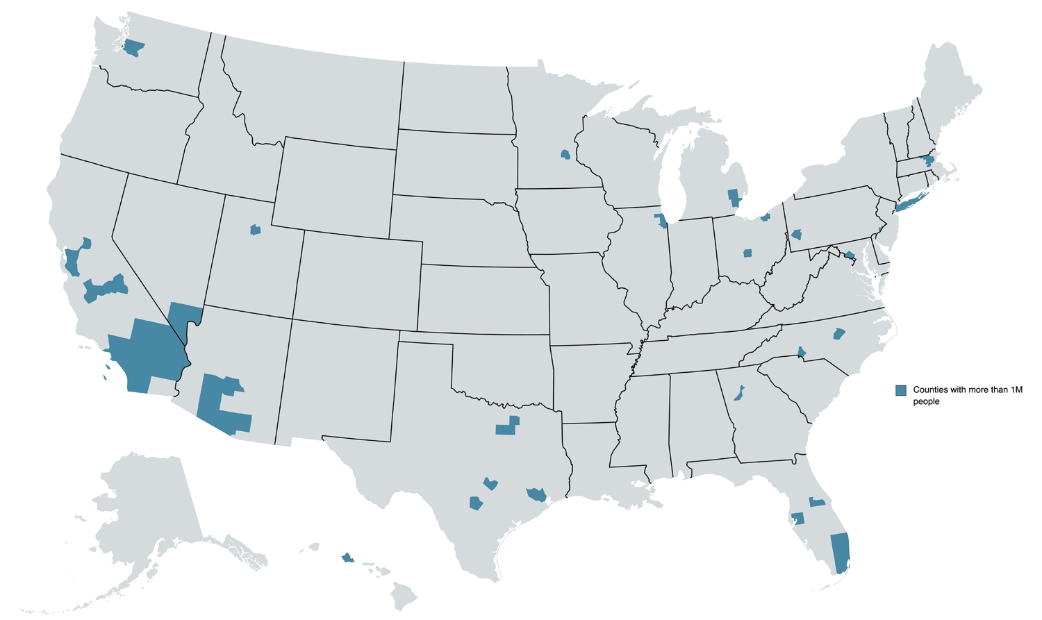
U.S. Counties With More than 1 Million People
Forty-three counties in the U.S. have a population greater than one million.
Population density
County populations vary broadly. According to the Census Bureau, more than 50% of the U.S. population is concentrated in just 143 counties (4.6% of all U.S. counties). The 5 most populous counties are Los Angeles County (California), Cook County (Illinois), Harris County (Texas), Maricopa County (Arizona), and San Diego County (California).

The largest population has Los Angeles County, where live more than 10 million people. New York is the most densely populated county in the United States (69,468 pop/sq mi or 26,822 Pop/sq km).
Most densely populated counties
| Rank | County | State | Pop/sq mi | Pop/sq km |
|---|---|---|---|---|
| 1 | New York | New York | 69,468 | 26,822 |
| 2 | Kings | New York | 35,369 | 13,656 |
| 3 | Bronx | New York | 32,903 | 12,704 |
| 4 | Queens | New York | 20,554 | 7,936 |
| 5 | San Francisco | California | 17,179 | 6,633 |
| 6 | Hudson | New York | 13,732 | 5,302 |
| 7 | Suffolk | New Jersey | 12,417 | 4,794 |
| 8 | Philadelphia | Pennsylvania | 11,379 | 4,394 |
| 9 | Washington | D.C. | 9,857 | 3,806 |
| 10 | Alexandria | Virginia | 9,314 | 3,596 |
It is to be expected that Yukon–Koyukuk Census Area in Alaska has the lowest population density.
Least densely populated counties
| Rank | County | State | Pop/sq mi | Pop/sq km |
|---|---|---|---|---|
| 1 | Yukon–Koyukuk | Alaska | 0.03 | 0.01 |
| 2 | Lake and Peninsula | Alaska | 0.06 | 0.02 |
| 3 | Yakutat | Alaska | 0.08 | 0.03 |
| 4 | North Slope | Alaska | 0.10 | 0.04 |
| 5 | Loving | Texas | 0.12 | 0.04 |
| 6 | Denali | Alaska | 0.14 | 0.05 |
| 7 | Northwest Arctic | Alaska | 0.21 | 0.08 |
| 8 | Esmeralda | Nevada | 0.21 | 0.08 |
| 9 | Garfield | Montana | 0.25 | 0.10 |
| 10 | Dillingham | Alaska | 0.26 | 0.10 |
More than half of all American residents live in just 143 big U.S. counties.
The shape of U.S. counties
One of the most interesting facts is that 414 American states are rectangular. Most of them are located in the Midwest. The map below shows all rectangular counties in the United States.

These counties have rectangular or square shapes because there aren’t sufficient natural barriers like rivers or lakes, so lines of latitude and longitude are used to mark borders.
Top U.S. states by number rectangular or square counties
Texas: 87
Kansas: 73
Iowa: 59
Nebraska: 46
Illinois: 19
South Dakota: 19
Missouri: 16
Minnesota: 15
Oklahoma: 13
Wisconsin: 11
Mississippi: 10
Colorado: 8
North Dakota: 8
Ohio: 7
Wyoming: 7
North Carolina: 6
Alabama: 3
Kentucky: 3
Florida: 2
Arizona: 1
New York: 1
The most unusually shaped counties have prominent geographical features, either bordering a body of water or having mountains, etc. For instance, below is the map of Monroe County in Florida.


Hi, I think this phrase in the article (The smallest county by area is Nevada, with 11.99 sq mi or 31.05 sq km.) is wrong. Did you mean the county in the state of Hawaii instead? Thanks
Dillingham is not a county, it’s in a borough. But point taken.
You have Hudson, NY and Suffolk, NJ. It should be Hudson, NJ and Suffolk, NY. There is no Hudson County in NY and there is no Suffolk County in NJ.
Not only that, but Suffolk County NY is not very densely populated. You must be thinking of Nassau County which is extremely densely populated. They are both on Long Island but Suffolk is out in the boonies compared to Nassau.
Suffolk County Massachusetts is the one you are looking for. Hudson County NJ and Suffolk Mass. Those are the winners.
I want to know (further): (a) which counties are SQUARE, or, if none, which are MOST-NEARLY square; and (b) are there ANY rectangular counties that are NOT ORIENTED to the four main points of the compass (say, diagonally)? I think there are, in Texas of course. Cochise County, Arizona is very-nearly square AND is the ONLY county that borders another country.