Almost every American state has something that makes it unique. The United States is a vast and diverse country, with each state offering its own distinct geography, history, and culture. From the rolling hills of the Midwest to the majestic mountains of the West, and the sunny beaches of the South to the bustling urban centers of the East, there is something fascinating in every corner of the nation. Below are maps of the U.S. states that highlight their uniqueness, revealing intriguing facts and lesser-known features that make each state stand out.
Alaska is the biggest U.S. state by area and the seventh-biggest subnational division globally. The size of Alaska is equivalent to the entire U.S. Eastern Seabord, spanning north to south from Maine to Florida and west to Tennessee.
Despite its large size, Alaska is sparsely populated. About half of Alaska’s inhabitants reside within the Anchorage metropolitan area. On the map below, green and blue and green areas have the same population.
Arkansas
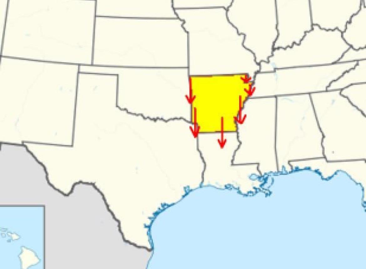
Arkansas has a curious bit of geography that’s easier to appreciate with a map in front of you: from somewhere in the state, you can head only south and still cross into each of its six neighbors. This happens because the state’s borders aren’t neat rectangles but a mix of river bends, angled survey lines, and Missouri’s distinctive “bootheel” that dips down into the Mississippi Valley. From the northwest, moving south takes you into Oklahoma; from the far northeast, you’ll clip that corner of Missouri before slipping into Tennessee across the Mississippi River. Farther east, a southern path leads into Mississippi, while the state’s bottom edge brings you straight into Louisiana. In the southwest, the same due south direction takes you into Texas.
You can travel south from Arkansas and get into every U.S. state it bordersMap of Arkansas
California
If California were an independent country, it would rank as the world’s 5th-biggest economy behind Germany, Japan, China, and the U.K. The map below shows six U.S. areas with roughly the same GDP as California.
Colorado
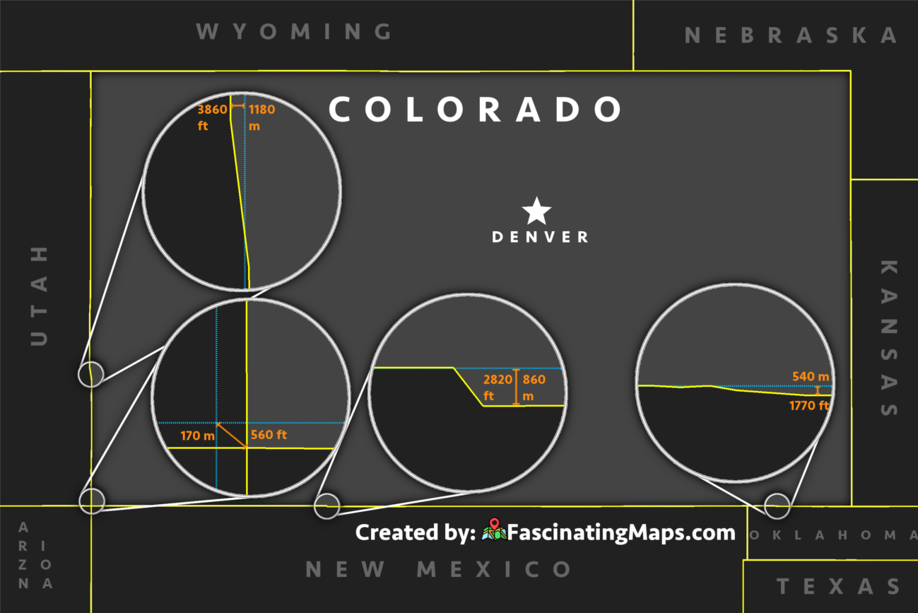
Is Colorado a perfect rectangle? Almost yes, but not quite. The map of Colorado’s border deviations is below.
Created by: FascinatingMaps.com
Colorado is not really rectangular, and it is, in reality, a 697-sider.
The borders of Colorado were fixed in 1850. Colorado’s borders were initially defined as lines of latitude and longitude, making its shape a latitude-longitude quadrangle that stretches from 37° N to 41° N latitude and 102.05° W to 109. 05° W longitude. On the northern side, the border is shorter than the southern one because circles of latitude get shorter as they get farther from the equator and closer to the poles. Colorado, Wyoming, and Utah are the only U.S. states with boundaries defined solely by latitude and longitude lines.
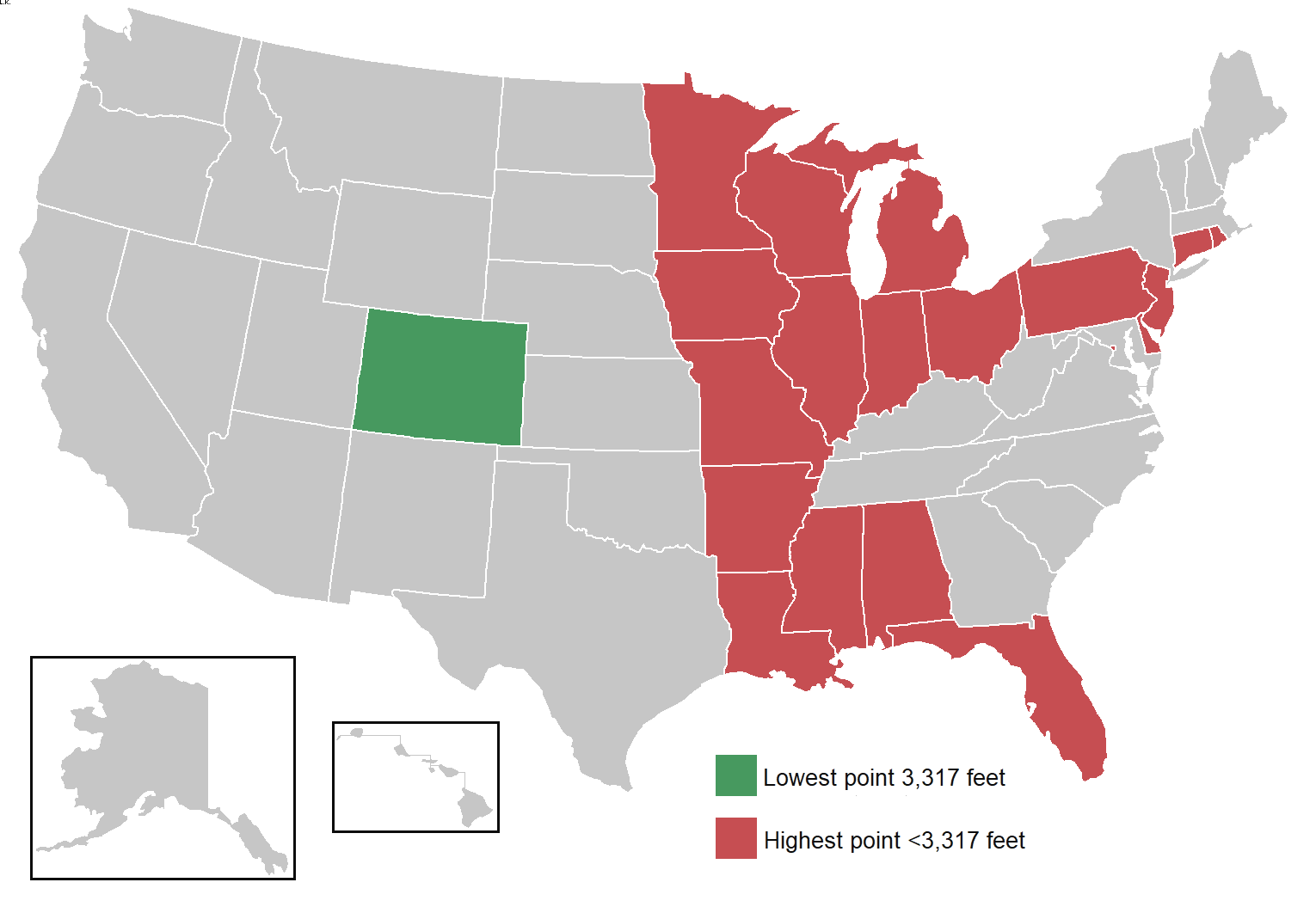
Colorado has the highest mean elevation of any U.S. state and the highest low point. As a result, Colorado could also be recognized as a candidate for “highest U.S. state”. Colorado’s lowest point is higher than 19 entire states, including Washington DC.
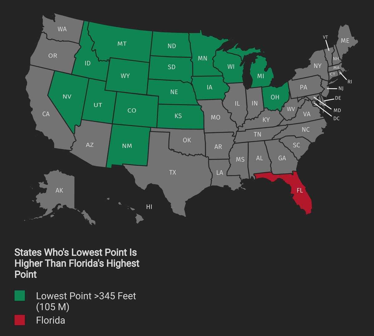
Florida
Britton Hill is the highest natural point in Florida, topping out at 345 feet (105 m) above sea level. No other U.S. state has a high point this low. The flattest state in the country, roughly 52% of Florida’s terrain is essentially level ground.
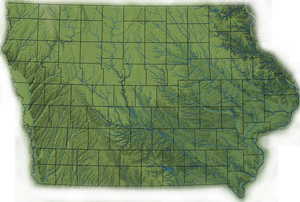
Iowa
Iowa is the only U.S. state whose eastern and western borders are entirely rivers.
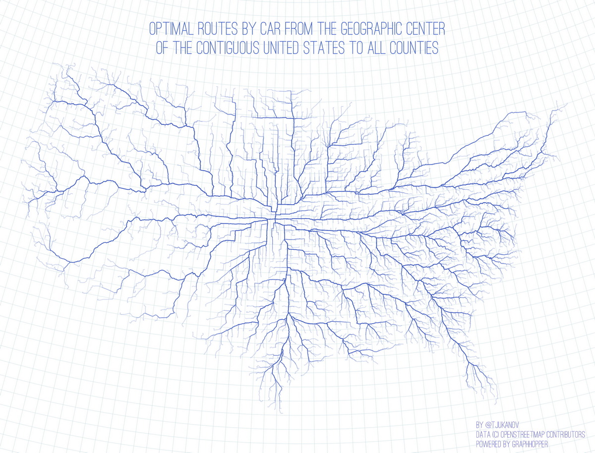
Kansas
Kansas isn’t just somewhere in the middle of the map — it’s literally the center. In fact, the geographic center of the contiguous United States is located about 2.6 miles northwest of the town of Lebanon, Kansas, in Smith County. That point was officially determined back in 1918. A fascinating map created by @tjukanov shows just how central Kansas really is.
The map uses real road data from OpenStreetMap and routing calculations from GraphHopper to chart the fastest driving route from this exact center to every county in the lower 48 states. The result looks almost like a root system, with lines spreading out evenly in all directions. It’s a fun reminder that Kansas quietly connects the country more than most people realize.
Mississippi
Mississippi is the poorest state, but there are not many countries in the world whose GDP exceeds that of Mississippi. The map below shows in blue the countries whose GDP is higher than Mississippi’s.
Nevada
Nevada may be vast in size, but nearly three-quarters of its 3.19 million residents live in Clark County, home to Las Vegas and its suburbs. That’s one small corner of the state accounting for a huge portion of the population. As of 2023, the Las Vegas metro area alone held 2.34 million people, with projections pushing that to nearly 4 million by 2043.
Remarkably, Clark County makes up just 7% of Nevada’s land, but dominates everything from politics to infrastructure planning.
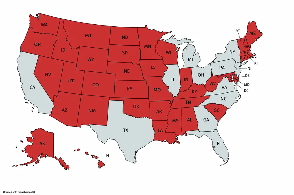
New Hampshire
New Hampshire is the 5th smallest U.S.state by area and the 10th least populated, with over 1.3 million citizens. The map below shows U.S. counties larger than New Hampshire.
New York
New York State is home to the most populous city in the United States. With almost 24 million in its combined statistical area, New York City is one of the world’s densest megacities. The map below shows the U.S. States with a smaller population than New York City.
Moreover, New York (50.8%) is the only state besides Hawaii (100%) where most people live on an island.
Hawaii
Hawaii is one of the most ecologically and biologically diverse places on the planet. The Big Island of Hawaii consists of 4 out of the 5 major climate zones and 8 out of 13 sub-zones of the Köppen classification system. The Hawaiian Islands are home to more than a unique 25,000 species of living organisms.
Reddit User ptgorman created a fantastic map of the climate zones of Hawaii based on the Köppen Climate Classification System and the data from Hawai‘i Magazine and Love Big Island. He gathered more than 1,000 Instagram photos using location tags and hashtags (selected for color) and placed them according to the climate zone map.
Rhode Island
Rhode Island is the smallest state by area (1,214 sq mi / 3,144 sq km) and the 7th-least populous (1,1 million), although it is the 2nd-most densely populated after New Jersey (1,006/sq mi or 388 sq km). The maps below show counties bigger than Rhode Island.
But Rhode Island is not a microstate! Even Rhode Island dwarfs several internationally recognized countries. Take Luxembourg, for example. This small European nation, known for its castles and high GDP per capita, covers just 2,586 square kilometers (998 square miles). That’s more than 50% smaller than Rhode Island.
Texas
Texas is the second-largest U.S. state by area after Alaska. But this U.S. state has its uniqueness. Texas is divided into 254 counties, more than any other U.S. state.
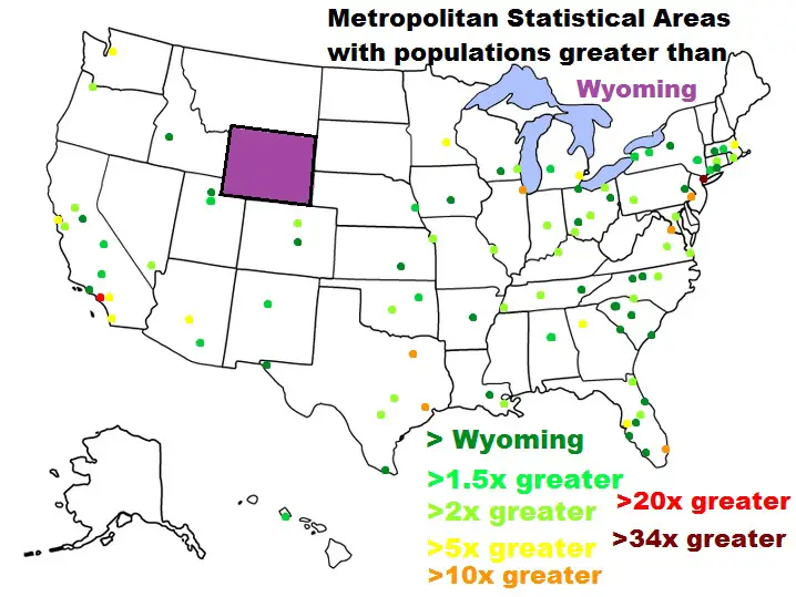
Wyoming
Wyoming’s population was about 577 thousand according to the 2020 U.S. Census, making it the least populated in the United States. The map below shows all U.S. counties more populated than a state.
Do you know any other amazing facts about the American states? Please feel free to write about it in the comments. For more maps about the U.S. administrative and political subdivision, see:


I heard Maine has more miles of coast than the rest of the Eastern US combined.