Great Britain is an island located in the North Atlantic Ocean and is part of the British Isles, a group of islands in Northwestern Europe. It is the largest island in the British Isles and is divided into three countries: England, Scotland, and Wales, each with its own distinct culture and identity.
To the east of Great Britain lies the North Sea, separating it from the continent of Europe, while the Irish Sea borders its west coast, separating it from the island of Ireland. The English Channel to the south separates Great Britain from continental Europe and the northern coast of France.
Great Britain, in addition to its main component islands of England, Scotland, and Wales, is also surrounded by numerous smaller islands that dot its coastline. These smaller islands, while individually diverse and distinct in character, collectively add to the richness of Great Britain’s geography and culture.
One notable group of smaller islands is the Inner and Outer Hebrides, located off the western coast of Scotland. These islands offer stunning natural beauty, with rugged coastlines, picturesque villages, and a unique Gaelic culture. The Inner Hebrides are closer to the Scottish mainland and include famous islands like Skye, Mull, and Islay, known for their dramatic landscapes and whisky production. The Outer Hebrides are further west and have a distinct identity, with the Gaelic language still spoken in some communities.
To the north of Scotland are the Orkney and Shetland Islands, which have their own Norse-influenced culture and heritage. These islands are known for their archaeological sites, including ancient settlements and stone circles, providing insights into early human history in the region.
In the Irish Sea, the Isle of Man stands as a self-governing Crown dependency with a unique identity and its own parliament. Known for its rich maritime history and the annual TT motorcycle races, the Isle of Man has a distinct legal and cultural status.
To the southwest of England, the Isles of Scilly form an archipelago, with a mild climate and beautiful beaches. These islands are known for their unique flora and fauna, attracting naturalists and tourists alike.
Off the western coast of Wales, Anglesey is the largest island in Wales, known for its historic sites, picturesque coastline, and connections to Celtic mythology.
These smaller islands surrounding Great Britain contribute to the overall charm and diversity of the region. They offer a mix of unique landscapes, cultures, and histories, making Great Britain and its neighboring islands a fascinating tapestry of geographic and cultural richness.
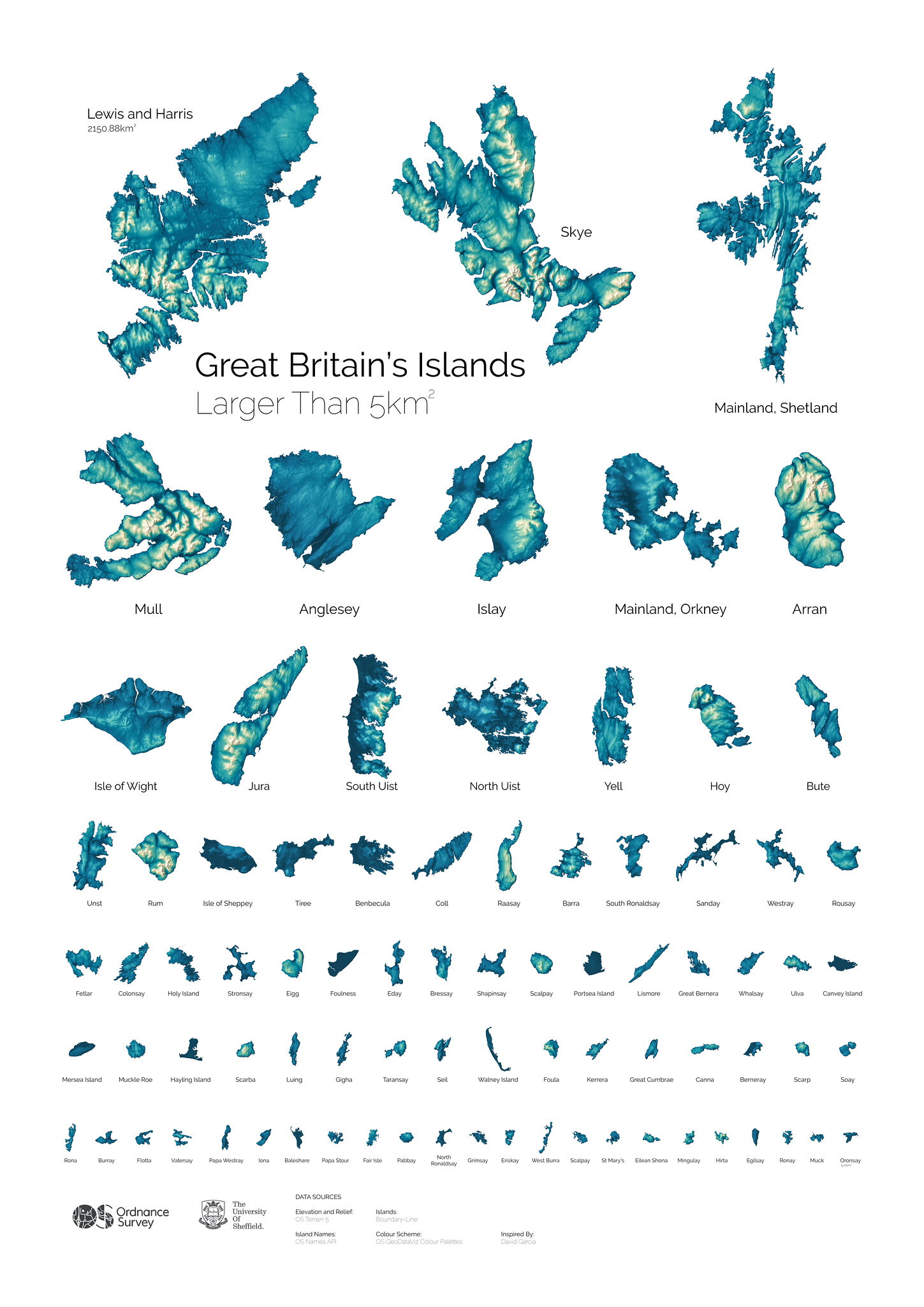
Below is the mini atlas of 82 Great Britain’s islands are larger than 5 square kilometers, created by Alasdair Rae at the University of Sheffield.
Top ten islands by area 1. Lewis and Harris 2. Skye 3. Mainland, Shetland 4. Mull 5. Anglesey 6. Islay 7. Mainland, Orkney 8. Arran 9. Isle of Wight 10. Jura
Top five islands by a length of coastline 1. Lewis and Harris 2. Mainland, Shetland 3. Skye 4. Mull 5. North Uist
Top five islands by residential addresses 1. Portsea Island 2. Isle of Wight 3. Anglesey 4. Isle of Sheppey 5. Canvey Island
If you’d like to read more about Great Britain, have a look at the following books and map:


Created by Ordnance Survey who worked with Alasdair Rae at the University of Sheffield.
Available also from their Flickr page https://www.flickr.com/photos/ordnancesurvey/albums/72157695297837382/with/43062058511/