In the world of hurricane forecasting, something quietly remarkable is happening. The “cone of uncertainty” – that familiar funnel-shaped graphic showing where a storm might go – is getting narrower. It’s a clear sign of just how much better scientists have become at tracking storms.
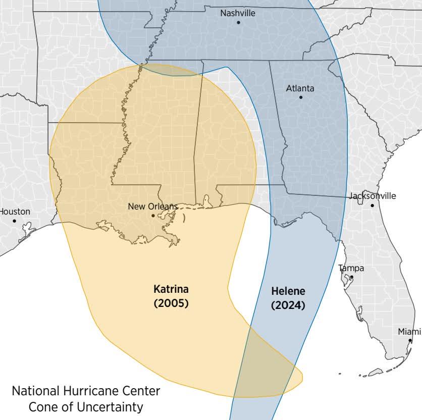
The side-by-side map above was created using forecast data from the National Hurricane Center (NHC). It compares the forecast cones for Hurricane Katrina in 2005 and Hurricane Helene in 2024. Both were modeled using five-day forecasts. Katrina’s path is shown in orange, Helene’s in blue – and the size difference between them speaks volumes.
Back in 2005, the average error for a 72-hour forecast was over 150 nautical miles (about 280 kilometers). By 2024, it had dropped to just 71 nautical miles (roughly 132 kilometers), according to Yale Climate Connections. That’s the smallest margin on record. The shrinking cone directly reflects that improvement.
So what’s changed? A few things. NOAA’s new-generation GOES-R satellites now deliver continuous, high-resolution views of storm systems. The National Weather Service also introduced the HAFS model (Hurricane Analysis and Forecast System) in 2023, replacing older forecast systems. Combine that with better storm recon flights, smarter data processing, and a huge leap in computing power, and you’ve got a recipe for much more reliable forecasting.
There’s still a challenge when it comes to predicting a storm’s intensity. Track forecasts have improved sharply, but figuring out how strong a hurricane will get is more difficult. The atmosphere is unpredictable, and rapid intensification is especially tricky to model. Still, progress is being made. According to NOAA’s verification data, the three-day intensity error has dropped by about 40% since the days of Katrina.
Forecast cones aren’t just graphics – they guide real decisions. Narrower forecasts mean emergency managers can give clearer instructions, and fewer people have to evacuate unnecessarily. That’s not just a convenience – it’s safer, more cost-effective, and less stressful for everyone in a storm’s path.


")


