The Netherlands, a country known for its picturesque windmills, tulip fields, and intricate canal systems, is also a fascinating case study in land use. Despite its relatively small size, the Netherlands has a diverse range of land uses, from agricultural fields and urban centers to natural reserves and inland water bodies.
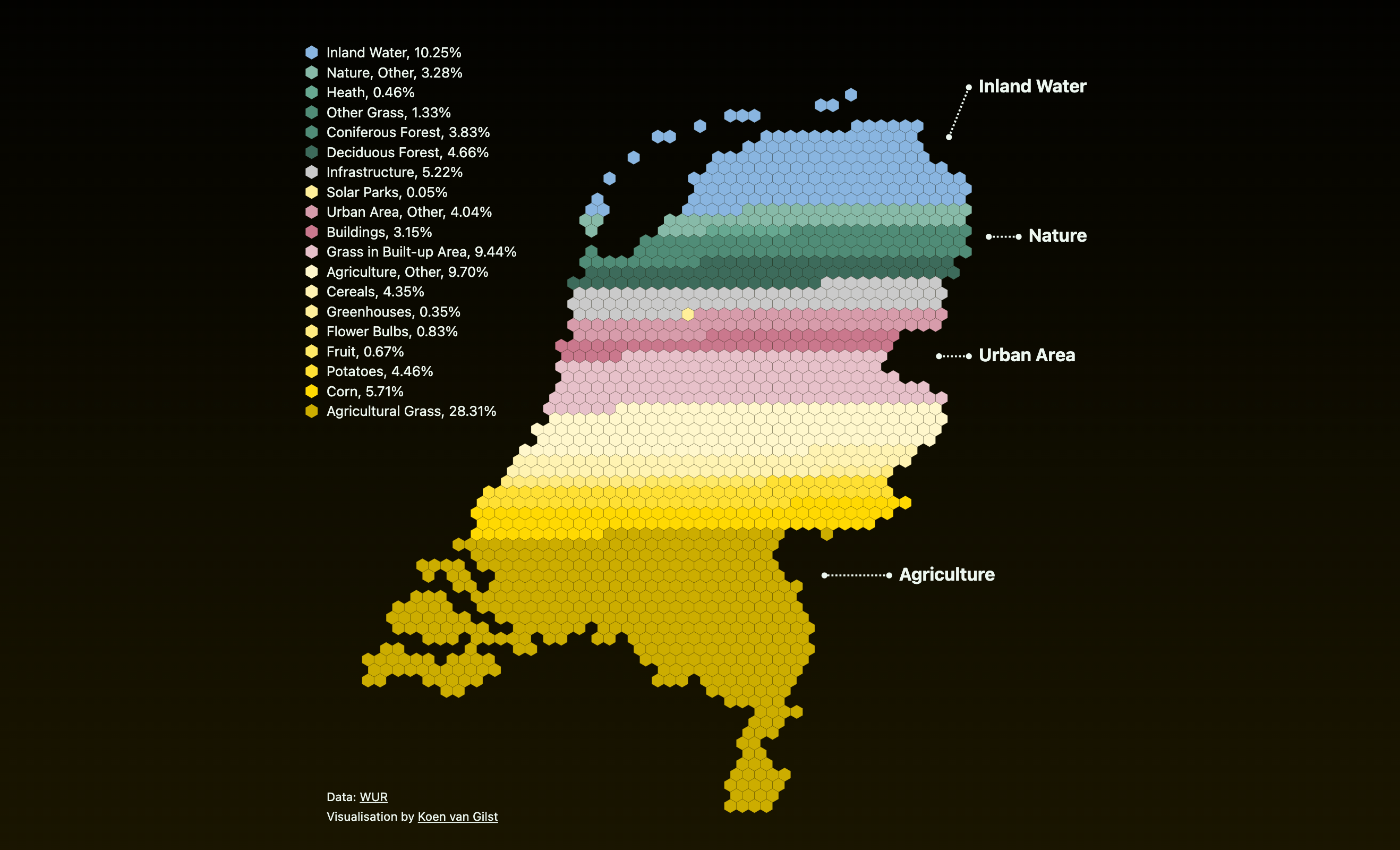
The map below created by Reddit user vngls, provides a quantitative illustration of land use in the Netherlands, highlighting the distribution of agricultural land, urban areas, natural landscapes, and inland water bodies.
Agricultural Land: Approximately 54% of the Netherlands is dedicated to agriculture. The fertile soil and moderate climate make it ideal for a variety of crops, including potatoes, vegetables, and of course, the iconic Dutch tulips. Despite its relatively small size, the Netherlands is one of the world’s largest exporters of agricultural products. This is made possible by highly efficient farming practices and advanced technology.
Urban Areas: Urbanization has been significant, with around 13% of the land covered by cities and towns. The Randstad, comprising Amsterdam, Rotterdam, The Hague, and Utrecht, is one of the most densely populated metropolitan areas in Europe.
Nature (Forests, Grasslands, and Nature Reserves): Nature reserves and forested areas cover about 15% of the land. These areas are crucial for biodiversity, providing habitats for various plant and animal species.
Inland Water: The Netherlands has a substantial amount of inland water, including rivers, lakes, and canals, covering around 9% of the country’s surface area. Water management is a critical aspect of Dutch land use, given the country’s low-lying topography.
Land Reclamation: Expanding Horizons
Land reclamation has significantly increased the area of the Netherlands, turning water into productive land. The most famous example is the Zuiderzee Works, which transformed a large inland sea into usable land, creating the province of Flevoland. The process of land reclamation involves constructing dikes and draining waterlogged areas, converting them into fertile polders.
The rate of land reclamation has varied over the years. Historically, large-scale projects like the Zuiderzee Works and the Delta Works have added substantial areas to the country. The area of the Netherlands has increased by approximately 7,000 square kilometers through reclamation projects.
The rate of land area increase has slowed in recent decades due to the complexity and cost of new projects. However, historically, the country’s area grew by about 0.2% per year during peak reclamation periods.
In contrast, the population has been steadily increasing. As of 2024, the Netherlands has a population of approximately 17.5 million, with a density of around 508 people per square kilometer, making it one of the most densely populated countries in the world.
Threats from Rising Sea Levels
Climate change poses a significant threat to the Netherlands, particularly through rising sea levels. With a substantial portion of the country below sea level, the risk of flooding is a constant concern. The Intergovernmental Panel on Climate Change (IPCC) predicts that sea levels could rise by up to one meter by the end of the century, which would have profound implications for the Netherlands.
The Netherlands is at the forefront of climate adaptation and mitigation strategies. The Delta Programme is a comprehensive initiative designed to protect the country from flooding, ensure freshwater supply, and adapt to climate change. Key components of the programme include reinforcing existing dikes, constructing new flood barriers, and creating flexible water management systems.
Innovative solutions like the Room for the River project aim to give rivers more space to manage higher water levels naturally. This project involves relocating dikes, deepening riverbeds, and creating floodplains, enhancing the capacity to cope with extreme weather events.
Additionally, the Dutch government and private sector are investing in sustainable urban planning, promoting green infrastructure, and reducing greenhouse gas emissions to mitigate the impacts of climate change.
Curious about the Netherlands? You’ll love these books.
?")


