Roughly 200 thousand years ago humans migrated from the East Africa Rift area into different parts of Africa.
At around 60 thousand ago humans migrated out of Africa to the rest of the world, making it to the tip of South America about 10 thousand years ago.
For the map below the Fuller projection was used to “straighten” this near circum-global route to better emphasize the sheer length of the 21 thousand mile walk.
Numbers on the map represent thousands of years before the present. Time bands were produced using interpolation from fossil sites with cartographic smoothing applied. Many theories exist regarding the precise dates of human migration. Map by Jeff Blossom.
Human migrations and fossils evidence
Two ways jump out as prime candidates for the human exodus out of Africa. A northern way would have taken our ancestors from their base in eastern sub-Saharan Africa across the Sahara desert, then through Sinai and into the Levant. An alternative southern route may have charted a path from Djibouti or Eritrea in the Horn of Africa across the Bab el-Mandeb strait and into Yemen and around the Arabian peninsula. The plausibility of these two ways as gateways out of Africa has been studied as part of the UK’s Natural Environment Research Council’s program “Environmental Factors in the Chronology of Human Evolution 8 Dispersal” (EFCHED).
During the last ice age, from about 80,000 to 11,000 years ago, sea levels dropped as the ice sheets grew, exposing vast swathes of land now submerged underwater and connecting regions now separated by the sea. By reconstructing ancient shorelines, the EFCHED team found that the Bab el-Mandeb strait, currently around 30 kilometers wide and one of the world’s busiest shipping lanes, was then a narrow, shallow channel.
Early humans may have taken this southern route out of Africa.
The northern route appears more straightforward, especially given the team’s finding that the Suez basin was dry during the last ice age. But crossing the Sahara desert is no small matter. EFCHED scientist Simon Armitage of the Royal Holloway University of London has found some clues as to how this might have been possible. During the past 150,000 years, North Africa has experienced abrupt switches between dry, arid conditions and a humid climate. During the more extended wetter periods, vast lakes existed in both Chad and Libya, which would have provided a “humid corridor” across the Sahara.
Armitage had discovered that these lakes were present around 10,000 years ago when there is abundant evidence for human occupation of the Sahara, as well as around 115,000 years ago when our ancestors first made forays into Israel. It is unknown whether another humid corridor appeared between about 65,000 and 50,000 years ago, the most likely time frame for the human exodus. Moreover, accumulating evidence is pointing to the southern route as the most likely jumping-off point.
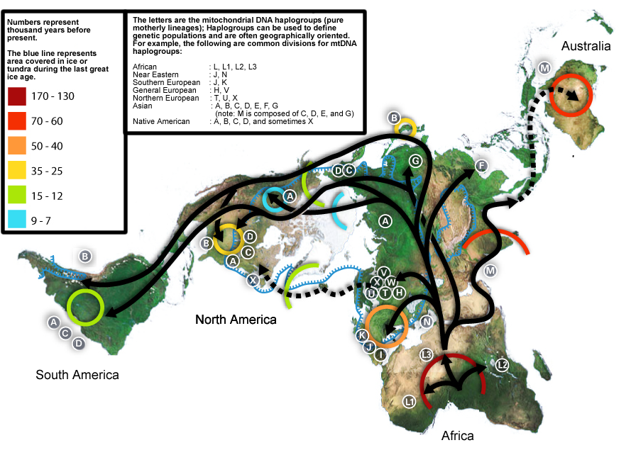
Human migrations and DNA haplogroups
The blue line represents the area covered in ice or tundra during the last great ice age.
The letters are mitochondrial DNA haplogroups (pure motherly lineages); Haplogroups can be used to define genetic populations and are often geographically oriented. For example, the following are common divisions for mtDNA haplogroups: African: L, L1, L2, L3 Near Eastern: J, N Southern European: J, K General European: H, V Northern European: T, U, X Asian: A, B, C, D, E, F, G (note: M is composed of C, D, E, and G) Native American: A, B, C, D, and sometimes X