Skip to content
Vivid Maps Logo

  • Atlases
  • Map Posters
  • Scratch Maps
  • Globes
  • Videos
Economic mapsJob
June 15, 2015 Alex

Largest % of Jobs by Industry Type by [Census Tract] 2013 ACS 5 Year

Top 20 the industries with the United States with the largest employment. Elementary and secondary schools Local government (excluding education

Read More
Resources
June 15, 2015 Alex

Trade oil flows worldwide (million tonnes)

Due to invention of the internal combustion engine, Petroleum or Crude Oil has become the largest source of energy consumption

Read More
Economic mapsHistorical Maps
June 13, 2015 Alex

Trade Routes of the Roman Empire

The roads and routes constructed and developed by the Roman bound all manner of peoples together, made possible the intermingling

Read More
Map of per capita income in the provinces of the Roman Empire in 1440
Economic mapsHistorical Maps
June 13, 2015 Alex

Per capita income in the provinces of the Roman Empire

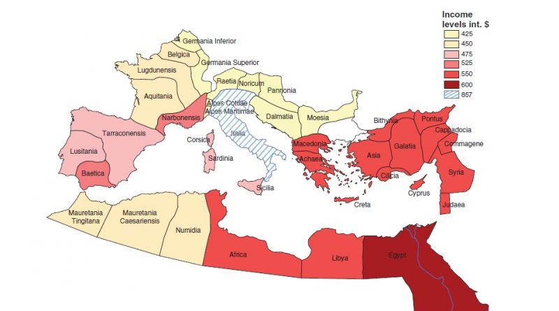
Economic historians differ in their estimates of the gross domestic product of the Roman economy. Per capita income in the provinces of the Roman Empire range from $425 to $867 (2000 US dollar). The GDP per capita of Italy is valued at approximately 50 percent higher than in the rest of the Roman Empire.

Read More
Europe's population changes mapped
Population
June 13, 2015 Alex

Population growth in Europe mapped

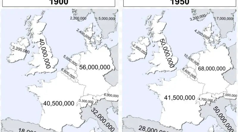
This blog post explores the population growth trends in Europe from 1900 to 2020, emphasizing both historical and current demographic shifts.

Read More
Wealth
June 13, 2015 Alex

100 richest (red) & 100 poorest (blue) counties in the US by per capita personal income

The U.S. counties with the highest per capita income is New York County, New York ($62,498), Arlington ($62,018), and Falls

Read More
Economic mapsTransport
June 13, 2015 Alex

Top 10 Most Job Accessible Cities in the US

Map showing the U.S. cities with the most jobs accessible within 30 minutes of walking or public transit.

Read More
Education
June 13, 2015 Alex

How long is the summer break?

In Europe, the school year usually ends at the end of May and the 2nd half of July. Mid-June is

Read More
Cars
June 13, 2015 Alex

Map of planned Tesla supercharger stations by end of 2016

Map of planned Tesla supercharger stations in USA by end of 2016 Map of planned Tesla supercharger stations in Europe

Read More
Historical MapsWars
June 13, 2015 Alex

World War II casualties as a percentage of the population

World War II was the deadliest military conflict in the history of humankind (85 million people were killed). The USSR

Read More
Page 644 of 682« First«...102030...642643644645646...650660670...»Last »

Trending now

  • The Price of Sex around the World Mapped
  • Map of the Central Pangean Mountains
    The Scottish Highlands, the Appalachians, and the Atlas are the same mountain range, once connected as the Central Pangean Mountains

Related Products

Push pin maps · Globe drinks cabinets · Maps of the United States · Board games · Monopoly · Map-based strategy board games · History Board Games · Coloring Books · Handheld GPS · GPS Watches · GPS Trackers

Vivid Maps Tools

· Convert Latitude/Longitude
· Elevation Finder
· Distance Calculator
· Kilometers to Miles Distance & Length Converter
· Weight Converter
· Volume Converter
· Temperature Converter
· Antipodes Map
· Find cities with a similar climate
· Find cities with a similar climate (2050)
· How hot cities could be in 2050
· The U.S. Population Lines

About
Privacy Policy

Copyright © 2026 Vivid Maps. All rights reserved.