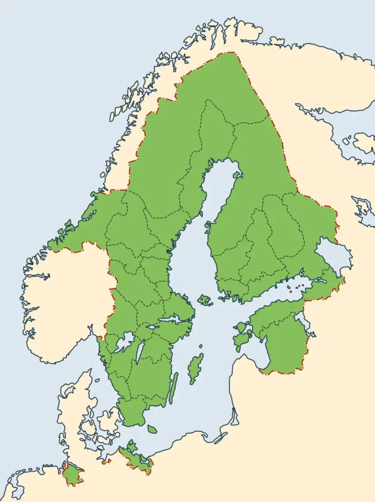
The Swedish Empire reached its largest size in 1658, when the Treaty of Roskilde forced Denmark-Norway to give up roughly a third of its territory. It then covered about 1.1 million km² (425,000 sq mi) but held only about 2.5 million people. The widest version of the map did not last, because Bornholm rebelled in December 1658 and Sweden returned it, along with Trøndelag, in 1660.
The peak came under Charles X Gustav, 26 years after Gustavus Adolphus died.
Only Russia and Spain controlled more land in Europe.
Population density was about 2.3 people per km² (6 per sq mi).
The Treaty of Nystad in 1721 stripped away most of the Baltic provinces.
Maps of the Swedish Empire show a confident arc around the Baltic Sea, as if Stockholm had grown into all that space naturally. It had not. About 2.5 million people held an area more than twice the size of modern Sweden, and the widest version of the empire was already coming apart within a year.
How big was the Swedish Empire in 1658?
According to Wikipedia, the Swedish Empire was around 1.1 million km² (425,000 sq mi) in 1658. Only Russia and Spain controlled more land in Europe. Stockholm stood near the center, with Riga, the second city, across the sea. Swedish territory took in the mouths of the Oder, Elbe and Weser, two-thirds of Lake Ladoga and half of Lake Peipus.
People were scarce. About 2.5 million lived there, roughly 2.3 per km² (6 per sq mi), or a quarter of today’s Swedish population. Far from the Baltic, New Sweden had also taken root on the Delaware River in 1638.
The map below shows the Swedish Empire and its various conquests.
Main Swedish holdings in 1658 and what became of them
Territory today
Joined Sweden
What happened later
Finland
Part of the realm before the empire era
Ceded to Russia in 1809
Northern Estonia
1561, when it asked Sweden for protection
Ceded to Russia in 1721
Ingria and Kexholm (northwest Russia)
1617, Treaty of Stolbovo
Ceded to Russia in 1721
Livonia (southern Estonia, northern Latvia)
1629, Truce of Altmark, confirmed at Oliva in 1660
Ceded to Russia in 1721
Gotland, Ösel, Jämtland, Härjedalen
1645, Treaty of Brömsebro
Swedish today, except Ösel (Saaremaa), ceded in 1721
Swedish Pomerania, Wismar, Bremen-Verden (northern Germany, northwest Poland)
1648, Peace of Westphalia
Lost over time, with Swedish Pomerania the last to go in 1814
Scania, Blekinge, Bohuslän, Halland
1658, Treaty of Roskilde (Halland held since 1645)
Swedish today
Bornholm, Trøndelag
1658, Treaty of Roskilde
Returned to Denmark and Norway in May 1660
Why did the widest map last such a short time?
Gustavus Adolphus built the army behind the empire, but he died in 1632. The widest borders came 26 years later under Charles X Gustav.
Charles wanted more. In August 1658 he invaded Denmark again, and by 11 August his troops overlooked Copenhagen. Dutch and English naval pressure helped end the siege. On 8 and 9 December the people of Bornholm rose against their new Swedish rulers. Charles died in February 1660. Three months later the Treaty of Copenhagen returned Bornholm to Denmark and Trøndelag to Norway.
How did the Swedish Empire end?
Defeat at Poltava in 1709 stopped Swedish expansion. The Treaty of Nystad in 1721 then handed Livonia, Estonia, Ingria and part of Karelia to Russia. Finland followed in 1809, and Swedish Pomerania, the last continental holding, went to Denmark in 1814 in exchange for Norway. About 110,000 soldiers from Finland died in Swedish service between 1617 and 1721.
Books on the Swedish Empire
Swedish Empire: A History from Beginning to End [AMAZON AFFILIATE LINK]