The age of borders: when were the world’s current borders first defined
A state border is a demarcation line that separates the territory of one country from another. It defines the political and legal boundaries between two or more sovereign states. State borders are typically established through treaties, agreements, or historical conventions, and the international community recognizes them.
State borders can take different forms depending on geographical features, historical factors, and political considerations. They can be natural, such as rivers, mountains, or coastlines, which serve as physical barriers between countries. In some cases, borders are artificial lines drawn on a map, often referred to as straight-line or geometric borders, which may not correspond to any natural features.
State borders have various purposes, including regulating the movement of people, goods, and services, as well as delineating the jurisdiction of each country. They help determine which government has authority over a particular territory and establish the framework for diplomatic relations, trade agreements, and the enforcement of laws.
State boundaries have changed countless times in the history of humanity. Powerful empires emerged, conquered neighboring states, reached their peak, and dissolved into oblivion.
Table of Contents
Imperial Density
The map below shows Imperial Density (number of Years Spent in an Empire Larger than 500,000km2) created by Reddit user Creative_Strawberry.
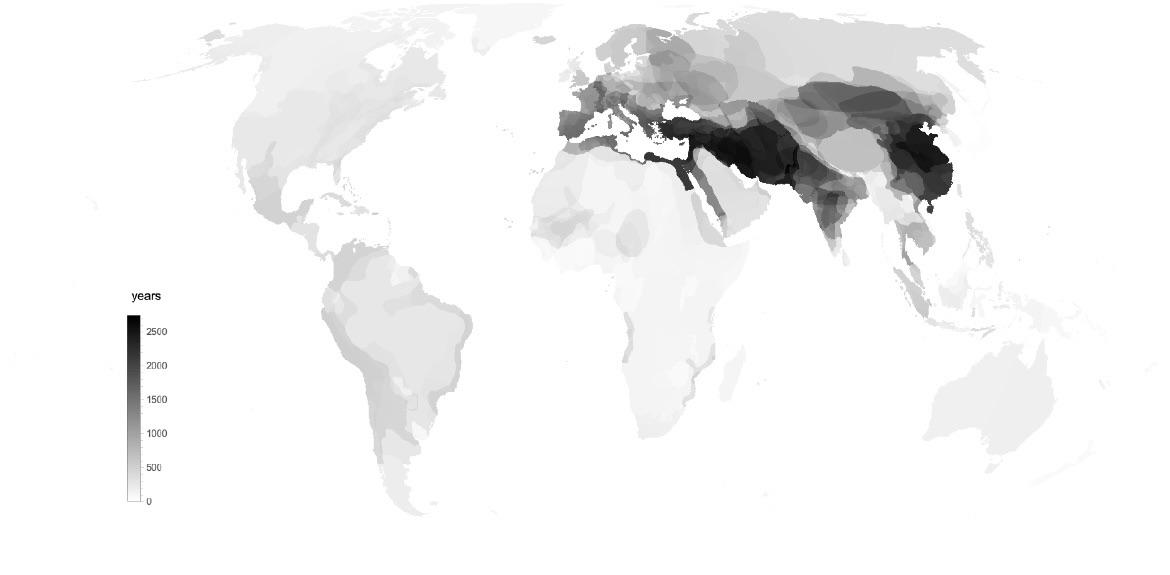
This map reveals that the borders of states changed most frequently in the Middle East and Eastern Asia, India, and the Mediterranean, where ancient civilizations originated and prospered.
Borders in our Era
Most of the modern world’s political borders were formed after World War I. World War II led to further shifts in political boundaries. As a result, 52.2 percent of the world’s borders were set during the 20th century.
The map below created by Reddit user PisseGui82 shows the age of the world’s borders existing nowadays.
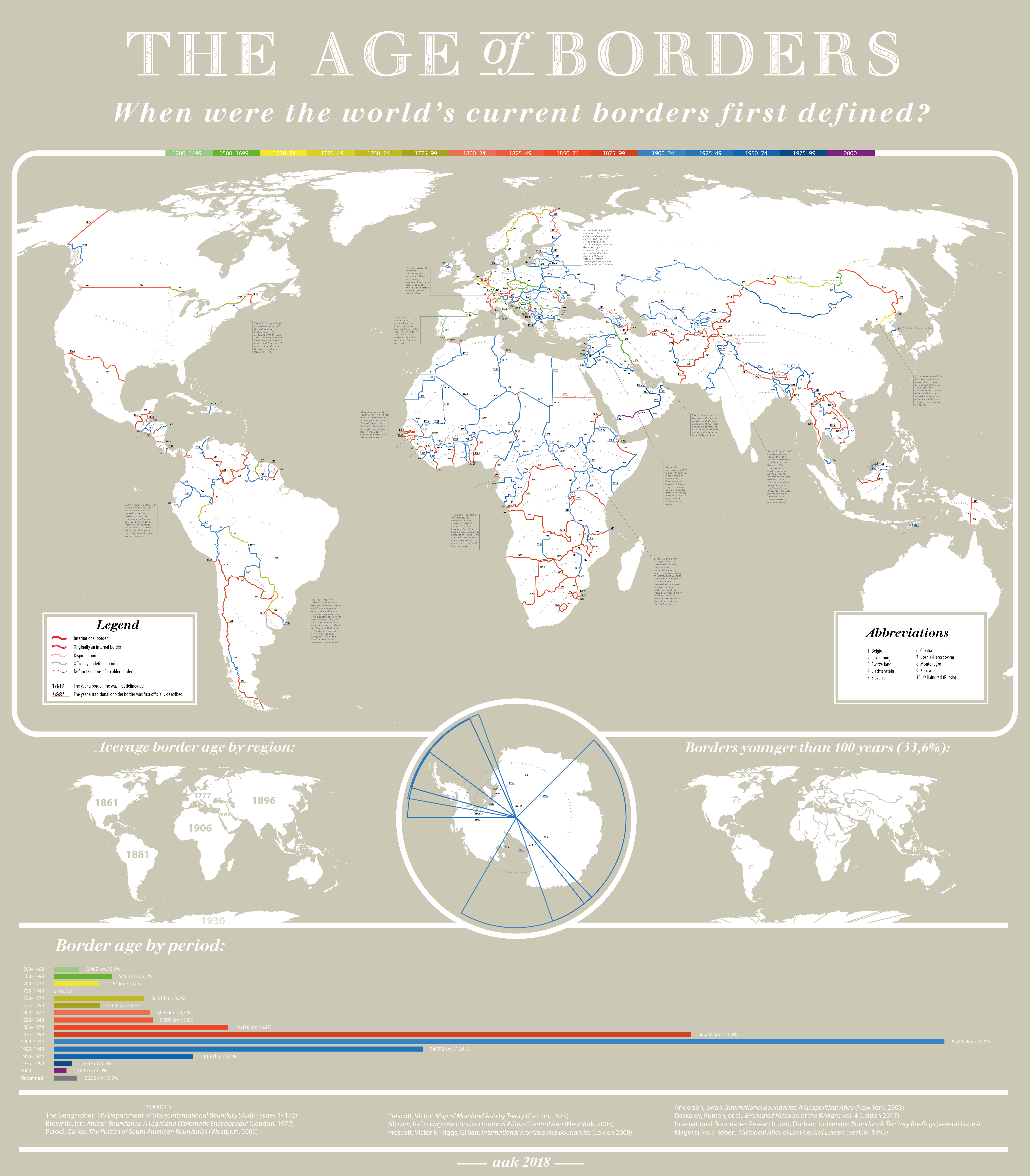
According to this map, the political boundaries changed the most from 1900 to 1924 (32.9 percent of the political boundaries changed). The total length of the political boundaries altered during this period was 83,897 kilometers (52,131 miles), more than twice the length of the equator. The next period of political instability was from 1875 to 1899. During this period, 60,046 kilometers (37,311 miles) of political boundaries (23.6%) changed.
The world’s borders by the time period when they were formed:
1200-1499: 2,405km (0.9%)
1500-1699: 5,463km (2.1%)
1700-1724: 4,264km (1.6%)
1725-1749: 0km (0%)
1750-1774: 8,491km (3.3%)
1775-1799: 4,350km (1.7%)
1800-1824: 9,025km (3.5%)
1825-1849: 9,309km (3.6%)
1850-1874: 16,416km (6.4%)
1875-1899: 60,046km (23.6%)
1900-1924: 83,897km (32.9%)
1925-1949: 34,752km (13.6%)
1950-1974: 13,130km (5.1%)
1975-1999: 1,674km (0.6%)
2000-today: 1,189km (0.4%)
Undefined: 2,202km (0.8%)
From the beginning of the eleventh century to the middle of the twentieth century, Europe was the center of the political life of the world, which decided not only the fate of the peoples inhabiting Europe but also the peoples of the Americas, Africa, Asia, and Australia. During this period, the political boundaries in Europe changed most frequently.
1000 years of state borders in Europe overlaid on one map
On the map below are presented all the borders of sovereign states in Europe in 100-year increments from 1000 to 2000. The entire European continent is covered by the lines of extinct and existing political borders on this map. The least changed the boundaries of political entities in what is now France, England, and Sweden.

Quick facts
Andorra’s mountainous 120km (74.6 mi) border with France and Spain was fixed in a feudal charter signed on 8 September 1278, making it the oldest remaining border in the world.
The 1783 Treaty of Paris defined the borders of the fledgling United States. In part, it coincided with the New York – Quebec (Later New York / Vermont – Quebec) border which was set 20 years prior and is today the oldest border in North America.
The 1815 Congress of Vienna, concluding the Napoleonic Wars, ‘reset’ many European borders to before the conflict and thus formalized many of them for the first time.
A stretch of roughly 200 kilometers (124 mi), first established as a border by the 1422 Treaty of Melno between the Teutonic Knights and the Grand Duchy of Lithuania, became an international border again in 1990, now between Russia’s Kaliningrad exclave and the Republic of Lithuania.
Internal borders of the French colonies were set at the discretion of the various governors and changed frequently, along with fluctuating administrative needs. Many were vaguely defined, and remain so after independence.
The Ottoman-Safavid War was ended by the Treaty of Zugab, signed on 17 May 1639, which defined what remains Asia’s oldest border. It currently divides Iran from Turkey and Iraq.
Originally conceived in 1916, the so-called Sykes-Picot Agreement divided the Ottoman lands between the UK and France. The plan was implemented after WWI, and its designs survive in many Middle Easter borders today.
During Britain’s 1947 partition of India, chairman of the Border Commissions Sir Cyril Radcliffe devised a line separating the Muslim from the Hindu areas to become the borders between India, Pakistan and what is today Bangladesh. The ‘Radcliffe line’ displaced 14 million people and led to three wars and several currently ongoing disputes.
Established in the 15 century, the Chinese-Korean border was formalized after a joint 1712 surveying expedition by Qin and Choson officials. A sacred mountain top between the Yalu and Tumen rivers remains disputed.
At the 1884-85 Berlin Conference, the European colonial powers divided Africa among them. These loosely defined lines became more specific as the exploration of the ‘Dark Continent’ continued, and largely remain in place as international borders today.
During the South American Revolutionary Wars, the various new republics agreed to the ‘uti possidetis’ principle, respecting the Spanish colonial borders as they were in 1810. Through various conflicts, these borders gradually eroded and today, only two small sections remain.
South Sudan’s borders are a patchwork of ill-defined colonial remnants. As preparations for the country’s independence, the Permanent Court of Arbitration in Hague decided on the disputed, oil-rich area of Abeyi on 22 July 2009, making it the world’s youngest border segment. The area remains disputed, but both claims adhere to the 2009 border.
Related post:
– Ten of the world’s shortest borders


Many lines but what about Aquitanie? I think that Duchy did belong to the English King for no less than 300 years….
I like the projection used for this map. Many others don’t show areas properly – see Where the world wants to go on holiday.
It is somewhat unfortunate that this map only has land borders. Surely some of the world’s naval borders have their own interesting history.
Also, I don’t see the Saint Martin/Sint Maarten border, and I suspect it’s not the only missing border either (if perhaps probably the most important one).
I was surprised not to see one of my favorite borders – the 15-kilometer border between Saint Martin (France) and Sint Maarten (Netherlands) on an island in the Caribbean Sea.
For what it’s worth, Wikipedia dates its formalization to 1817.
The France-Italy border was redrawn in 1947, though!
I feel like this should be the first module in high school geography that students are taught. As a Canadian (HS 1999-2003 – no, I didn’t fail; we had grade 13), I know we were never educated on border formation – certainly not in the way it’s presented here. I really find the time period and share of border formation interesting.
One formating suggestion on the map (which is also a great resource!), maybe make the middle two reds and blues more distinct. It’s difficult to tell them apart when looking at the map as opposed to viewing the legend with the lines side-by-side.
Glad I found this site! And hope that I can find this map for sale somewhere…