When you stand at the beach, it looks like the land ends where the water begins. But that’s not really the case. The land keeps going underwater, and in some places, the seafloor stretches out for more than 100 miles before it drops into the deep ocean. That underwater extension? That’s what geologists call the continental shelf.
The Continental Shelf Boundary (CSB) defines where U.S. drilling and mining rights end offshore.
Individual states manage waters close to their shores – typically three nautical miles (5.6 km). Texas, Gulf Coast Florida, and Puerto Rico are exceptions – historical claims give them nine nautical miles (17 km). Past state waters, you hit the Outer Continental Shelf (OCS). Federal land underwater. About 5 million square miles (13 million sq km) of it.
The Exclusive Economic Zone (EEZ)extends 200 nautical miles (370 km) from the coast and covers around 4 million square miles (10.4 million sq km. The U.S. controls commercial fishing and seabed mining within this zone. Closer to shore, the territorial sea extends 12 nautical miles (22 km), where the U.S. has complete authority.
Most places, the CSB stops at 200 nautical miles. But sometimes the shelf keeps going past that. Geologists did surveys and found places where it extends way further. They call those Extended Continental Shelf zones (ECS). The CSB goes out to 350 nautical miles (648 km) in ECS areas.
Last December, the State Department made the ECS boundaries official. They designated seven regions: the Arctic, Atlantic, Bering Sea, Pacific, areas around the Mariana Islands, and the Gulf of Mexico divided into eastern and western sections. These regions total about 381,000 square miles (987,700 sq km). The Arctic accounts for most of it – roughly 201,000 square miles (521,000 sq km).
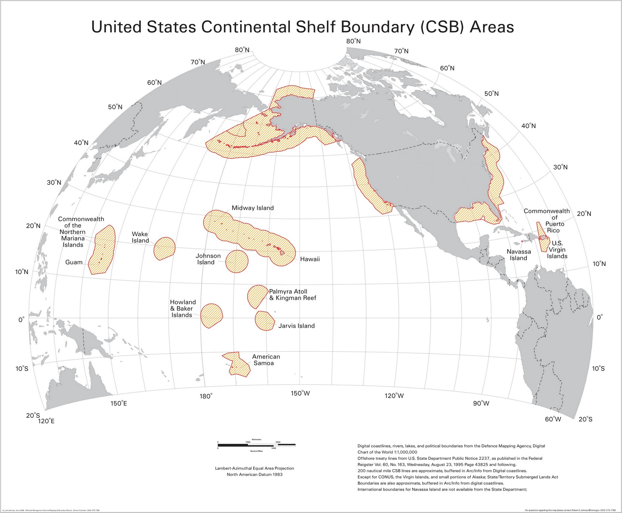
The map displays CSB areas surrounding U.S. territories that came under American control between 1776 and 1986.
Territory
Year
How Acquired
Continental U.S.
1776-1845
Original states & expansion
Alaska
1867
Purchased from Russia
Navassa Island
1857
Guano Islands Act
Howland & Baker Islands
1856-1857
Guano Islands Act
Jarvis Island
1856
Guano Islands Act
Johnston Atoll
1858
Guano Islands Act
Palmyra Atoll & Kingman Reef
1859-1862/1922
Various claims
Hawaii & Midway Island
1898/1959
Annexed/Statehood
Puerto Rico
1898
Treaty of Paris
Guam
1898
Treaty of Paris
Wake Island
1899
U.S. claim
American Samoa
1900
Deed of Cession
U.S. Virgin Islands
1917
Purchased from Denmark
Northern Mariana Islands
1947/1986
UN Trust/Commonwealth
Seven of those Pacific islands (Navassa, Howland, Baker, Jarvis, Johnston, Palmyra, Kingman) were claimed under the Guano Islands Act in the same way. In the 1850s, bird droppings were valuable because synthetic fertilizer did not exist yet. Seabirds had been nesting on remote islands for thousands of years, leaving behind large guano deposits. Any American could claim an uninhabited island if it had guano.
Alaska has the largest CSB zone. When the U.S. bought it from Russia in 1867, that included massive Arctic and Bering Sea areas. Hawaii controls a big zone in the central Pacific. Tiny islands create surprisingly large CSB zones – hundreds of miles out from specks of land. Puerto Rico and the Virgin Islands extend U.S. jurisdiction into the Caribbean. Guam and the Northern Marianas are located in the western Pacific, geographically closer to Manila and Tokyo than to California.


?")


