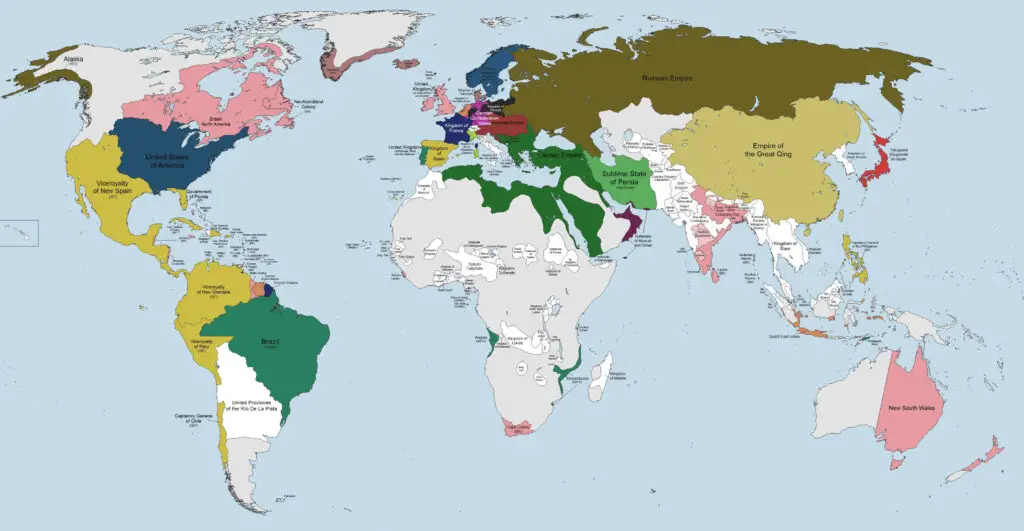
World map from the time humanity reached its first billion people
Nowadays is estimated that the human population of the world reached one billion for the first time in 1804-1815. It would be over 100 years before it reached two billion in 1927, but it took only 33 years to touch three billion in 1960. This is because of considerable decreases in the death rates starting in Western Europe and then extending throughout the rest of the world, most lately, to poor, undeveloped nations.
| 1 Billion | 1804 |
| 2 Billion | 1927 (123 years later) |
| 3 Billion | 1960 (33 years later) |
| 4 Billion | 1974 (14 years later) |
| 5 Billion | 1987 (13 years later) |
| 6 Billion | 1999 (12 years later) |
| 7 Billion | 2011 (12 years later) |
| 8 billion | 2023 (12 years later) |
But let’s go back to the beginning of the 19th century. Although the world’s population has only just reached 1 billion, on the world’s political map, one can find many countries whose borders differ little from those of modern nations.
The first French empire, which was ruled by Napoleon Bonaparte and dominated much of continental Europe, ceased to exist in 1815. After that, the world was left with five great powers: France, Britain, Russia, Austria, and Prussia. Italy became a great power only in 1860 because of the Italian unification. By 1905, two fast-growing non-European states, the United States and Japan, had joined the Great Powers.
The 19th century was Europe’s colonial century. At the start of the period, the only colonial empire that existed was the British Empire. By the end of the century, the situation was utterly distinct, and Europe’s colonial possessions had become a considerable part of the world.
This directed imperialist and colonialist contests for influence and power worldwide. British Empire created an informal economic system that, associated with its colonies and Royal Navy, made it the hegemonic nation until united Germany contested its power. U.S. relations with Great Britain became progressively rocky during this period.
Romania, Bulgaria, Serbia, and Montenegro originally operated as sovereign vassals, for until about 1908-1912 they were lawfully still part of the weakening Ottoman Empire, before obtaining their autonomy.

The decisions taken at the Congress of Vienna redraw the political map of Europe.
Prussia grows to include a piece of the Grand Duchy of Warsaw, Swedish Pomerania, over half of Saxony, and the more significant part of the Rhineland. Russia takes Finland, part of Poland, and excludes Bessarabia from the Ottoman Empire. Austria regains the Tyrol and takes Dalmatia and the kingdom of Venetian Lombardy, while Sweden annexes Norway from Denmark. Switzerland got Basel and several territories around Geneva.
Defeated France regains the borders that the country had in 1792. To restrain its potential territorial ambitions in the future, two buffer states are strengthened at its borders:
- The kingdom of the Netherlands, which comprises Belgium (in the north)
- The kingdom of Piedmont-Sardinia regains Savoy, the county of Nice, and extends to include the region of Genoa (in the south).
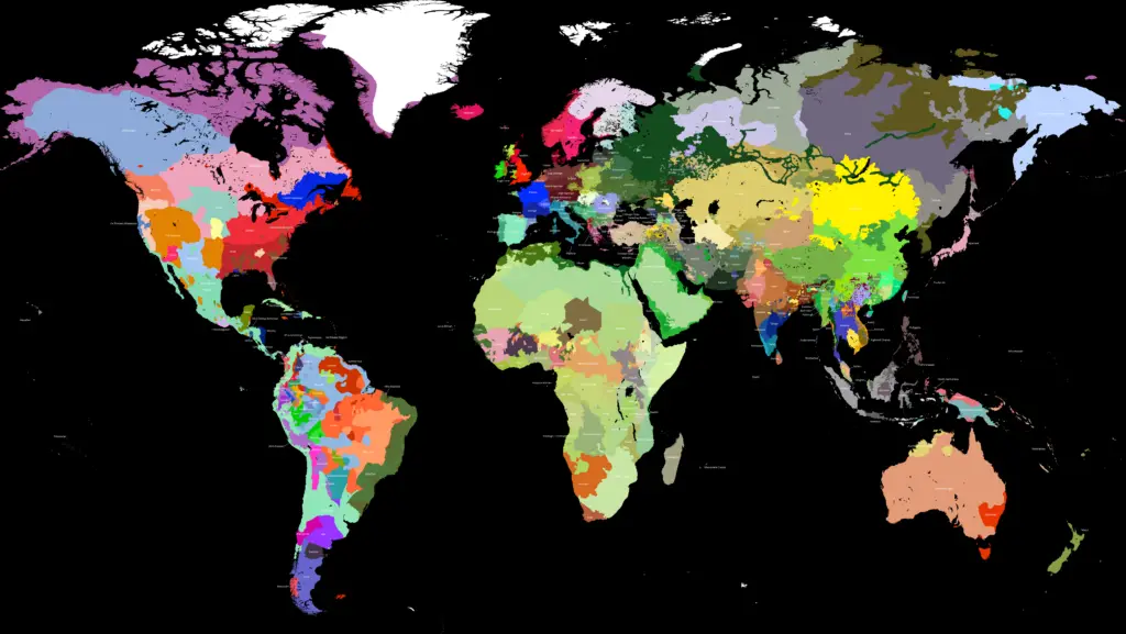
These political boundaries strongly influenced the ethnic composition of 19th century countries. Below is the 19th Century ethnic world map created by Reddit user Hammonia.

If you want to know more about 19th-century history, check out the following books.


“At the start of the period, the only colonial empire that existed was the British Empire.”
What about the Spanish, Portuguese and Russian empires? All were colonial and all existed at the time of the Congress of Vienna.