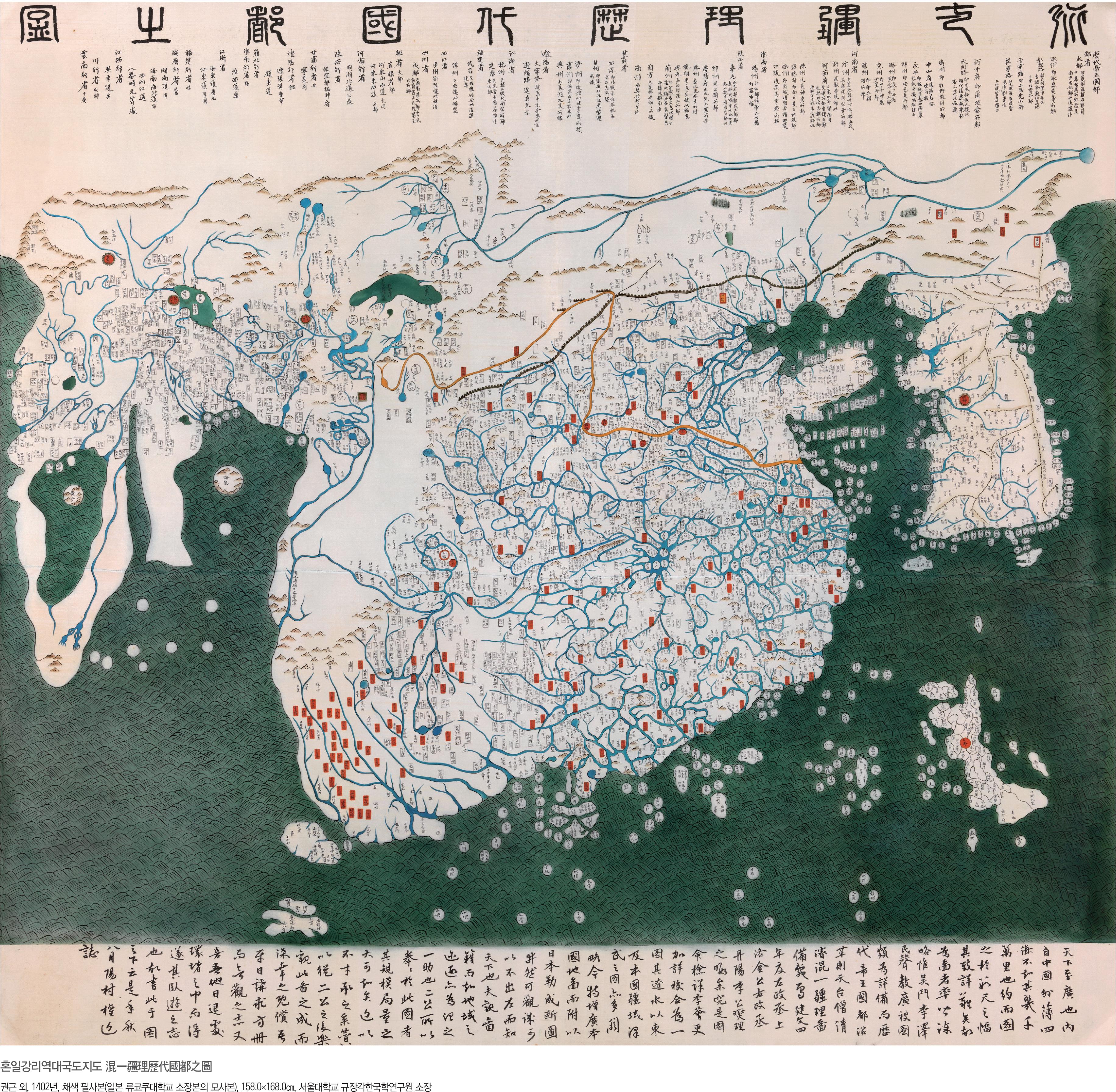
In 1402, scholars at the court of the newly founded Joseon dynasty in Korea finished a world map that showed Europe, Africa, the Middle East, and East Asia on a single sheet. That may not seem unusual until you take the date into account. It would be 1498 before Vasco da Gama would circumnavigate the southern tip of Africa. Yet this map already shows it, clearly and roughly correctly, with about 35 African place names including Cairo and Mogadishu.
The full title is 混一疆理歷代國都之圖, usually transliterated as Honil Gangni Yeokdae Gukdo Ji Do, translated as “Map of Integrated Lands and Regions of Historical Countries and Capitals.” Most people just call it the Kangnido. It was completed by the Korean scholars Kwon Kun and Yi Hoe, working from two older Chinese maps that Korean ambassador Kim Sa-hyong had brought back from a diplomatic mission to China in 1399 – Li Zemin’s Shengjiao Guangbei Tu (ca. 1330) and Qingjun’s Hunyi Jiangli Tu (ca. 1370). Those Chinese maps had in turn absorbed geographical knowledge from Islamic cartographers who circulated through the Mongol Empire‘s trade networks.
Kwon Kun and Yi Hoe found those Chinese sources lacking, particularly on Korea and the regions east of Liaodong. So they enlarged Korea substantially, added a map of Japan, and filled in what the Chinese sources had missed. The result is a map that places China at the center – enormous, as was conventional – with a noticeably oversized Korea to its east. Europe and Africa appear small in the west, compressed but present. Over 100 European place names are on the map, including “Alumangia” for the Latin word Alemania (Germany) and a transcription of the Arabic name for Paris. The Mediterranean is there. The Iberian Peninsula is there. The Nile flows from the “Mountains of the Moon” into a large central African lake before reaching the sea at Cairo, marked with a small pagoda symbol for the Lighthouse of Alexandria.
There’s one detail about this map that historians find genuinely puzzling. It uses the Ming Chinese era name “Jianwen” – but the Jianwen Emperor lost a civil war in 1402 and the new emperor immediately banned that era name. The Kangnido keeps it anyway, even on the later copies. The most plausible explanation: this map was never shown to the Chinese. It was a Joseon state secret, a document of national prestige kept behind closed doors.
No original survives in Korea. Two known copies are currently in Japan. The most notable is housed at Ryūkoku University in Kyoto, acknowledged to be the earliest and in the best condition – it likely arrived in Japan during Toyotomi Hideyoshi’s invasions of Korea in the late 16th century. The Ryūkoku copy is 158.5 by 168 cm, painted on silk. A second copy was found in 1988 at Honkōji temple in Shimabara, Nagasaki – larger at 220 by 280 cm, painted on paper.
Even the oldest Ryūkoku copy reflects Korea’s administrative situation as late as around the 1470s, meaning it was partially updated from the 1402 original – so what you’re looking at in any reproduction is not exactly what Kwon Kun and Yi Hoe finished in 1402, but a revised version made perhaps 70 years later. Still, it’s the best record we have of what the original contained.


