Argentina Turned Upside Down: A Bicontinental View from the South
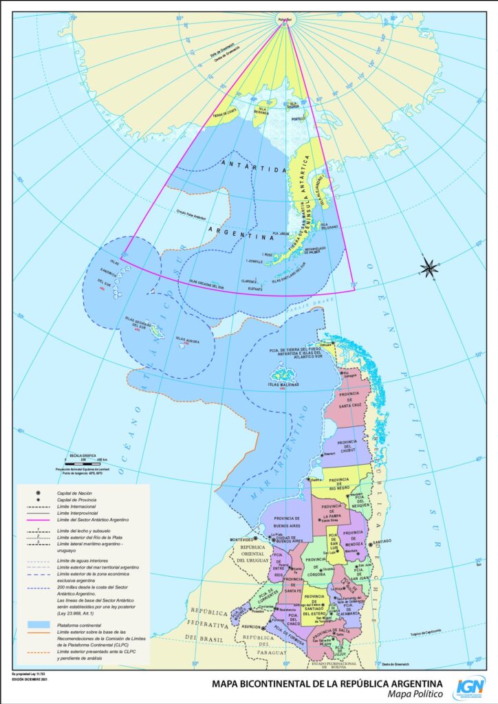
Argentina’s National Geographic Institute (Instituto Geográfico Nacional, or IGN) publishes many maps, but one in particular caught my eye recently. It’s not just because it’s well-drawn or official—it’s because it turns the world upside down, quite literally. This south-up version of the Mapa Bicontinental de la República Argentina shows the entire national territory, including Antarctica, rotated so that the South Pole is at the top. For those of us living in the Northern Hemisphere, this orientation can feel a bit disorienting at first. But honestly, I find it refreshing. It helps me see things from a different angle—one that, in some ways, makes more sense.

This map is not a novelty. It’s official policy. Since 2010, Argentina has legally required public institutions and schools to use the bicontinental map, which includes the Argentine Antarctic Sector along with the rest of the country. The law—Ley 26.651—was passed to reflect Argentina’s geopolitical stance and to make its presence in Antarctica and the South Atlantic visible to all citizens.
Looking at this map, it becomes clear that it does more than flip directions. It visually connects southern Patagonia, Tierra del Fuego, the Islas Malvinas (Falkland Islands), Islas Georgias del Sur, and Islas Sandwich del Sur, as well as Argentina’s claim to a slice of Antarctica. This triangular Antarctic sector stretches from meridians 25°W to 74°W all the way down to the South Pole. Though Argentina’s Antarctic claim is regulated by the Antarctic Treaty System, which freezes new claims and limits enforcement, Argentina maintains scientific and logistical bases on the continent and considers it a core part of its national territory.
Also visible on the map is the maritime space around the claimed islands and Antarctica. Argentina’s exclusive economic zone and extended continental shelf are shown in dotted lines. These boundaries are based on Argentina’s submission to the Commission on the Limits of the Continental Shelf (CLCS), recognized in part by the UN in 2016.
What I especially enjoy about maps like this is how they challenge our habits of perception. Growing up with north at the top of every map conditions us to see the world from a single perspective. Flipping it doesn’t just turn Argentina upside down—it also tilts our assumptions. It makes geographic connections clearer, especially in the Southern Hemisphere, and reorients the viewer to Argentina’s sense of space and national presence.
I recently posted a south-up map of Brazil as well, and the experience was similar. These kinds of maps are more than cartographic experiments—they help me better understand spatial relationships and national outlooks that often get overlooked in standard projections.


