Remember pulling on ropes at the beach as a kid, convinced you’d found the ocean’s drain plug? Ryan Brideau (Reddit user Vinnytsia) turned that into something real.
Brideau made an animation showing 158,180 years of ocean drainage through a 10-meter plug in the Mariana Trench. He used the ETOPO1 Global Relief Model—basically bathymetric data at 1.8-kilometer resolution covering Earth’s entire surface, land and sea.
The idea? Straight from Randall Munroe’s “What If?” book (Amazon link). Munroe takes ridiculous questions and answers them with actual science.
The Mariana Trench is in the western Pacific, around 200 kilometers (124 miles) east of the Mariana Islands. Length: 2,550 kilometers (1,580 miles). Width: about 69 kilometers (43 miles). The Challenger Deep, its lowest point, reaches 10,994 meters (36,070 feet) down.
Drop Mount Everest in there? Its peak would still be 1.6 kilometers underwater.
Pressure at the bottom reaches 1,086 bars. That’s a thousand times surface pressure. Water gets 5 percent denser down there. Temperature stays between 1 and 4°C, but life exists around hydrothermal vents anyway.
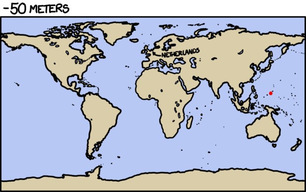
On the animated map above, each frame lowers the water level by 10 meters (33 feet).
During those first 200,000 years, the coastlines transform completely. Land bridges appear. Islands turn into mountain peaks. Seabeds become new landmasses.
At the end, the Pacific drains almost completely. The Atlantic and Indian Oceans are cut off early when seafloor ridges emerge, blocking their connection to the Pacific.
Interesting fact: even though the Mariana Trench is the deepest, it’s not the closest to Earth’s core. The planet bulges at the equator, so parts of the Arctic Ocean floor are 13 kilometers (8 miles) closer to the center.
Want to see water changes on Earth? I’ve created maps showing ice melt flooding and water loss—the first shows what happens when all ice melts, the second shows oceans disappearing like they did on Mars.


I wonder what would happen if it were to close? Could it cause a world encompassing flood? Hey Noah!