Currently, Iran is home to about 89 million people (2024), making it the 18th most populous country in the world. It covers around 1.65 million square kilometers (about 636,000 square miles), ranking 17th in area globally. The population density is relatively low—about 54 people per square kilometer (roughly 140 per square mile)—though some provinces are far more crowded than others.
Iran’s economy is resource-rich, particularly in oil and natural gas. It’s a founding member of OPEC. As of 2025, the country’s nominal GDP is around $341 billion, which places it behind nations like Saudi Arabia and Turkey. GDP per capita is about $3,897—below the global average but higher than many countries in the region.
Despite economic sanctions and inflation, Iran has strong industries in manufacturing, petrochemicals, agriculture, and technology. Its literacy rate is high (over 90%), and the country maintains a large and youthful workforce.
Iran’s present isn’t something that happened overnight. Its current shape, culture, and politics are all the result of thousands of years of change—some gradual, others sudden. To understand how Iran got here, maps are a good place to start.
Here are five maps that offer different lenses into Iran—its history, climate, people, and languages.
1. The Entire History of Iran, Animated (600 BCE to 2020)
This animation compresses over 2,600 years of Iranian history into just 8 minutes. It tracks the shifting borders and dynasties of the region, from the Achaemenid Empire through the Parthians and Sassanians, to Islamic Caliphates, Mongols, Safavids, and the modern nation-state.
What you see is more than just war and conquest. It’s also the story of how a civilization holds on to an identity across time—Persian culture, language, and political ideas have a long memory.
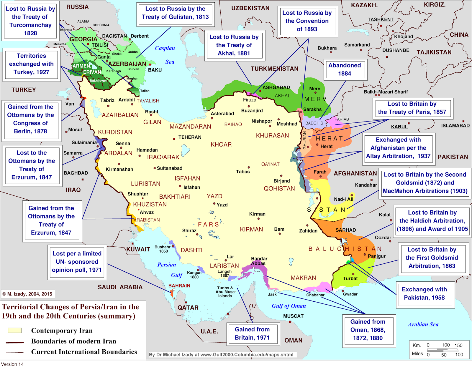
2. Territorial Changes of Iran Since the 1800s
In the 19th and early 20th centuries, Iran lost large parts of its territory to imperial powers. This map summarizes treaties and arbitrations with Russia, Britain, and the Ottomans—showing how Iran’s borders were carved, contested, and redrawn.
Seeing these shifts on a map helps explain Iranian skepticism of outside interference. These territorial losses are still remembered and discussed today, especially in conversations about national pride, sovereignty, and security.
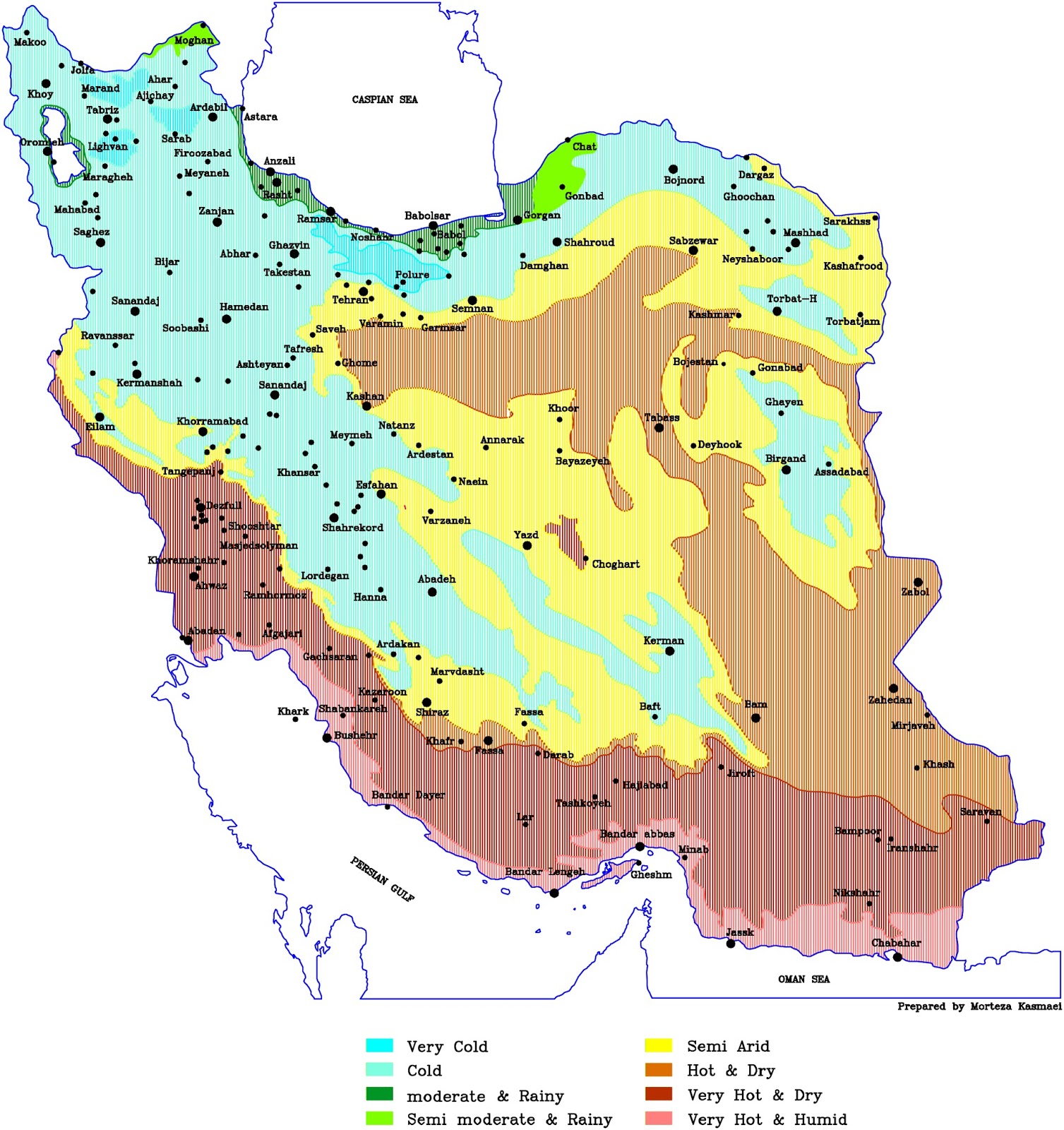
3. Iran’s Climate Zones
Iran’s landscapes vary dramatically—from cool, wet forests along the Caspian Sea to harsh deserts in the center and hot, humid air near the Gulf.
This map shows nine different climate zones, which helps explain why you’ll find rice paddies in the north and palm groves in the south. Climate also influences architecture, farming methods, and even how cities are built.
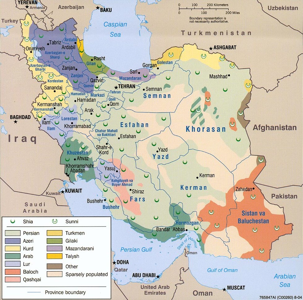
4. Ethnicity and Religion Across Iran
Iran isn’t just Persian. It’s home to Azeris, Kurds, Arabs, Baloch, Lurs, Turkmen, and others. This map shows where various ethnic and religious groups live.
While the majority of Iranians are Shia Muslims, there are significant Sunni populations—especially among Kurds, Baloch, and some Arabs. Understanding these divides helps explain regional differences and some political tensions inside the country.
5. Iran’s Languages
Iran is multilingual. Persian (Farsi) is the official language, but Azerbaijani Turkish, Kurdish, Arabic, Balochi, Luri, and others are widely spoken. This map makes it easy to see where different languages are rooted.
In some regions, you might find bilingual communities or people who speak three languages: Persian for school and government, their native tongue at home, and Arabic in religious contexts.
Bonus: Iranic Languages Beyond Iran
If you zoom out, the language story gets even more interesting. This map shows how Iranic languages—like Persian, Kurdish, Balochi, and Pashto—extend beyond Iran’s borders. They’re spoken across Central Asia, Afghanistan, Iraq, and into the Caucasus.
Iran’s influence doesn’t end at its borders. Linguistically, the region shares a common heritage that stretches across modern nations.
These maps offer a more layered view of Iran—its roots, diversity, geography, and ongoing connections. They don’t explain everything, but they’re a great way to start seeing Iran not just as a country on the news, but as a place shaped by many forces over time.