(Is there) Life on Mars?
Is there life on Mars? It depends how you interpret the question.
The chances of anything coming from Mars are a million to one according to Jeff Wayne. To date, the human species has yet to find evidence of biological life on Mars but we persist in our efforts to try and establish whether we are alone in the universe. The Curiosity lander has found evidence of flowing water which has certainly whetted our appetite further.
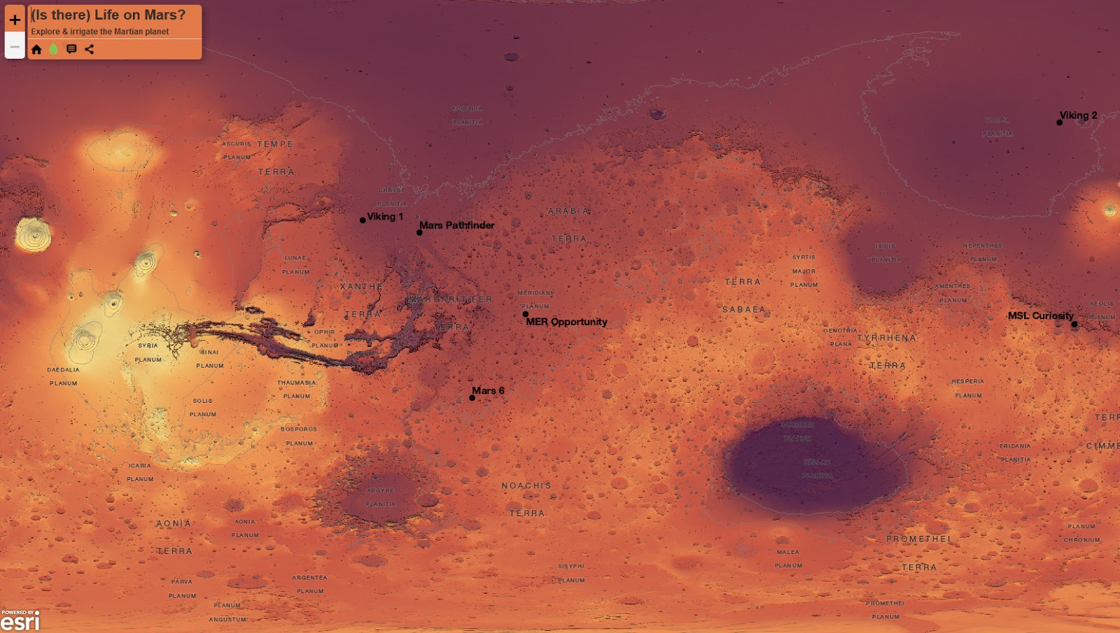
This map paints a picture of Mars and all that we, as a species, have done to explore that far away fiery red planet. We’ve certainly been enthralled about our distant neighbour and taken life TO Mars through various space missions and astronomical observations. So yes, there is life on Mars…life that we’ve applied through landing man-made craft and through naming features.
The map can be explored simply through pan and zoom but every crater that is marked by an abstract symbol (at large scales) can also be clicked to find out more about the feature.
Spacecraft landings and their details are also shown through the surface plaque screwed to the Martian surface. CLick to reveal details of the landings (or crashes).
And what about water? Evidence has recently been found that suggests water once flowed on the planet so it might be fun to see what it would look like with oceans.
Mars has a much greater range of elevation than Earth. The deepest point on Earth is in the Mariana Trench at 10,994m below sea level and the highest peak is Mt Everest at 8,848m above sea level. While we use sea level as Earth’s vertical reference datum, no sea level exists on Mars. However, elevation is measured against a proxy reference datum called the Mars areoid. The lowest point on Mars is found in the Hellas Impact Crater at 8,200m below the areoid. The highest peak is Olympus Mons volcano at 21,229m above the areoid.
You can irrigate the planet below the areoid on this map using the water layers. You’ll notice the water layers aren’t blue. On Earth, water appears blue due to red, orange, yellow and green wavelengths of light being absorbed more strongly than blue and also the reflectence of the blue sky. Since Mars has relatively little atmosphere and it’s farther from the sun it’s likely water will appear differently. We’re imagining wavelengths will be absorbed differently, perhaps returning an alien green?
Of course, Mars has been mapped many times before. Giovanni Schiaparelli’s map from 1880 maps classical albedo features based on his own astronomical observations. His initial naming conventions names ‘seas’ and ‘channels’. Of course, USGS has it’s own official topographic maps of mars. More recently, Chris Wesson’s map in the style of an Ordnance Survey sheet presented the Martian landscape in an alternative way. Eleanor Lutz map is also of a small extract of part of the planet, hand-drawn in a medieval styled effort. On these, and many other, maps of Mars, landscape features are named using the following conventions.
Catena (catenae): chain of craters
Cavus (cavi): hollows, irregular depressions
Chaos (chaoses): distinctive area of broken terrain
Chasma (chasmata): steep-sided depression
Collis (colles): collection of small hills or knobs
Crater (craters): circular depression (impact event)
Davida (bowiae): hidden map element
Dorsum (dorsa): ridge (wrinkle ridge)
Fluctus (fluctūs): terrain covered by outflow of liquid
Fossa (fossae): long, narrow, shallow depression
Labes (labēs): landslide debris
labyrinthus (labyrinthi): intersecting valleys or ridges
Lingula (lingulae): tongue of land
Mensa (mensae): flat-topped with cliff-like edges
Mons (montes): mountain or mountain range
Palus (paludes): small plain
Patera (paterae): irregular crater with scalloped edges
Planitia (planitiae): low plain
Planum (plana): plateau or high plain
Rupes (rupēs): scarp
Scopulus (scopuli): irregular Slope
Serpens (serpentes): sinuous feature with relief
Sulcus (sulci): subparallel furrows and ridges
Terra (terrae): extensive land mass
tholus (tholi): small domical mountain or hill
Unda (undae): Field of dunes
Vallis (valles): Valley
Vastitas (vastitates): Extensive plain
Large craters are named after deceased scientists who have contributed to the study of Mars; writers and others who have contributed to the lore of Mars.
Small craters are named after villages of the world with a population of less than 100,000.
Multiscale map from 1:73million to 1: 4million. Contour interval is 1000m at maps largest scale.
Projection: Mars 2000 Equidistant Cylindrical (based on Plate Carrée)
Elevation data from the Mars Orbitor Laser Altimeter (MOLA) instrument on the MGS (NASA/JPL/GSF) at approximately 463m/px.
Official IAU/USGS approved nomenclature from the MRCTR GIS lab (USGS).
Landing site data from NASA.
Map made by Kenneth Field using ArcGIS Pro and ArcGIS Online, 2016.
Via arcgis.com


