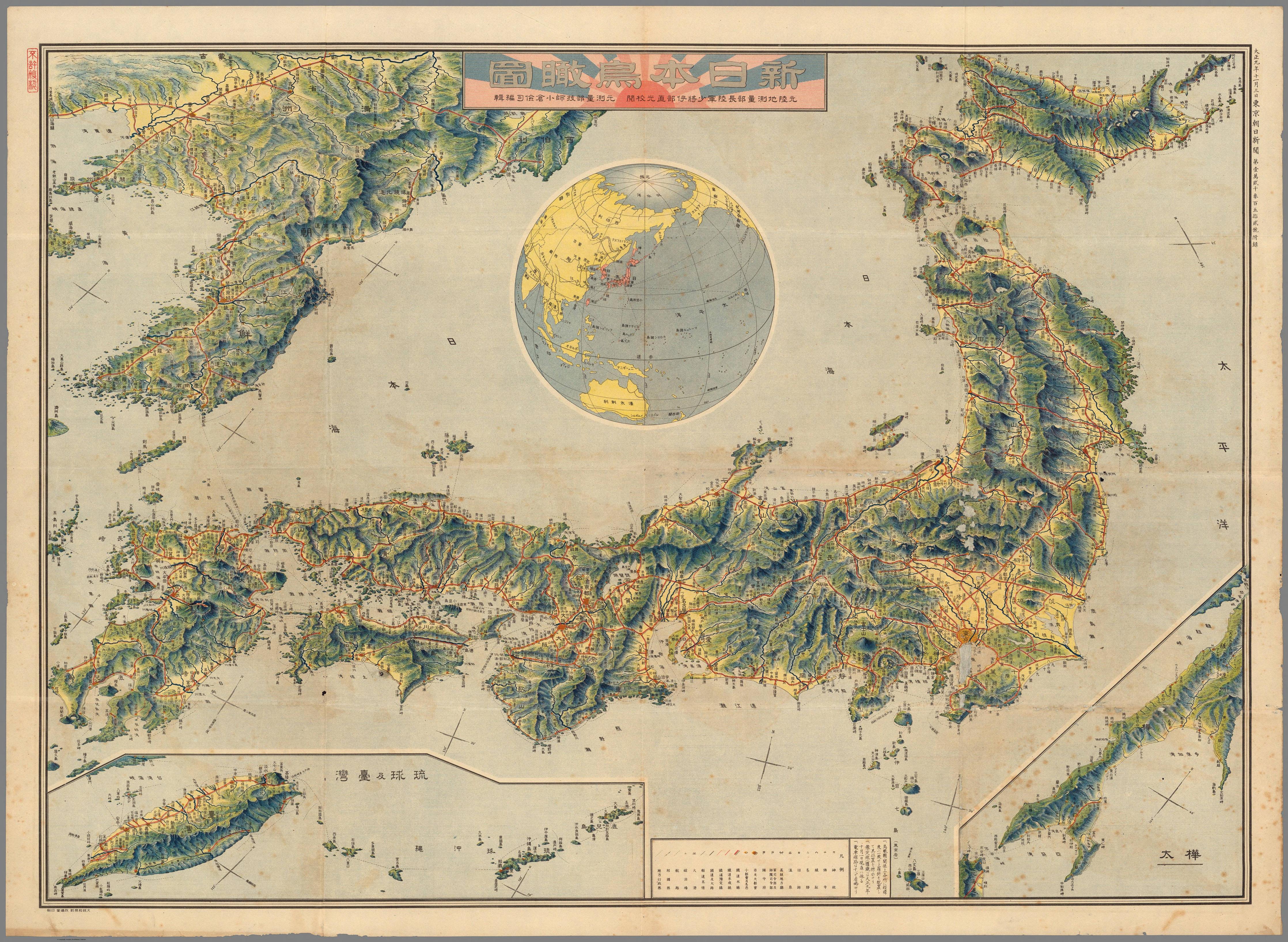
One morning in early November 1921, readers of the Tokyo Asahi Shimbun opened their paper to find a large, illustrated bird’s-eye view of Japan and its empire tucked inside – titled 新日本鳥瞰図 (Shin Nihon Chōkanzu), “Bird’s Eye View of the New Japan.”
It was compiled by Ogura Kenji, a former Army surveying engineer, and authorized by Lieutenant General Ibe Naomitsu, former chief of the same bureau – real military cartographers, not illustrators.
The first thing you notice looking at the map is the relief (mountains layered in deep green). Japan’s four main islands are there, but the map pushes out past them – to the Korean Peninsula, Taiwan, and Karafuto, the southern half of Sakhalin that Japan took from Russia after the 1905 war. The lower-left corner has a second inset, zooming in on the Ryukyus and Taiwan.
Red lines thread through the landscape – bold for existing railways, thinner for routes still being built. By 1921, that network connected ports, garrison towns, and industrial centers across the home islands and into the colonial territories. The cartographers also marked Shinto shrines, Buddhist temples, hot springs, fortifications, roads, and shipping lanes.
This short film was shot on Japan’s streets that same year – craftspeople making parasols in workshops, women weaving artificial flowers, children queuing at a street vendor’s lollipop stall:
Category
Japanese Empire (1921)
Japan (2025)
Total controlled territory
~681,000 km² (incl. Korea, Taiwan, Karafuto, Ryukyus)
377,975 km²
Japan proper land area
~382,000 km²
377,975 km²
Population (Japan proper)
~55.96 million (1920 census)
~123.4 million
Capital
Tokyo
Tokyo
Tokyo (prefecture)
~3.7 million (1920 census)
~14.2 million
Osaka (city)
~1.25 million (1920 census)
~2.83 million
Nagoya (city)
~430,000 (1920 census)
~2.26 million
Army active personnel
~300,000 (18 permanent divisions)
~247,000 (Japan Self-Defense Forces)
Naval/defense spending
~32% of national budget (navy alone, 1921)
~2% of GDP (JSDF total, 2025)
Emperor
Emperor Taisho; Hirohito as Regent from Nov 25, 1921
The Asahi Shimbun published this on November 3, 1921, and nine days later Japan’s delegation was in Washington D.C. for the Washington Naval Conference – the first arms control conference in history. Japan came away as one of five recognized world powers, the first Asian nation to be treated as an equal in that kind of setting. By then, the navy alone consumed nearly 32% of the national budget.
The political backdrop in Japan that November was complicated. Historians tend to call the Taisho era “Taisho Democracy” – more open than what came before, more internationally minded. The military, though, still reported directly to the Emperor rather than the civilian government, and that never changed. Emperor Taisho himself had been in serious mental decline for years. His son Crown Prince Hirohito had just returned from the first European trip any Japanese crown prince had ever made and was formally appointed regent on November 25 – three weeks after this map was in people’s hands. He married Princess Nagako in 1924 and became Emperor only in December 1926, after his father’s death.
Under the Five-Power Treaty signed in Washington, Japan accepted a ceiling of 315,000 tons of capital ships against 525,000 each for the United States and Britain. Nobody in Tokyo celebrated the limits. The Japanese naval chief who had pushed hardest for expansion reportedly called it the opening of a war.