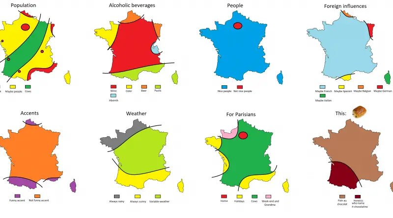
Map of the Ancient Roman World from Their Perspective
Discover how ancient Romans saw the world through maps like Orbis Terrarum and Pomponius Mela’s Orbis Habitabilis. Learn how these maps reflected the Roman Empire’s power and worldview.
Read MoreDiscover how ancient Romans saw the world through maps like Orbis Terrarum and Pomponius Mela’s Orbis Habitabilis. Learn how these maps reflected the Roman Empire’s power and worldview.
Read MoreMatt Wuerker’s 2018 cartoon “The Great Wall of America” cleverly blends politics, gun culture, and isolationism. Explore the deeper message behind this witty map.
Read MoreStep into the mind of Ancient Rome with two humorous maps that show how Romans might have seen the world in 125 AD — from “stinky people” to “crazy religions.”
Read MoreWhy are countries like Sweden, Finland, and Denmark so confident about their children’s future? Explore the social policies and factors driving this optimism — and how it’s linked to overall happiness.
Read MoreThe US political borders can be classified into international and internal. An international boundary delineates the space between sovereign nations (Canada-USA-Mexico). Internal boundaries are more bureaucratic and used to break up space into manageable parts of administration.
Read MoreAnimals make some of the most incredible journeys on Earth. A falcon flying 10,000 km in 42 days? An Arctic fox walking across sea ice to another continent? Explore these epic migrations through detailed maps and fascinating facts.
Read MoreHow safe do people feel walking alone at night? Gallup’s Global Safety Report reveals that global safety perceptions have improved over the past decade — but not everywhere. Find out which countries feel the safest and least safe today.
Read MoreDid you know that Canada literally means “The Village” and Ethiopia translates to “Land of Burnt Faces”? Explore these surprising and insightful translations of country names from around the world.
Read MoreAbout 95% of Egypt’s 107 million people live along the Nile and in the delta. Explore maps showing how Egypt’s population density is shaped by the river’s life-giving waters.
Read MoreFrom the Viking-named Shetlands to the Celtic roots of Cornwall, Britain’s county names tell stories of ancient kingdoms and forgotten peoples. This detailed map of the United Kingdom reveals the surprising meanings behind familiar place names and the historical forces that shaped them.
Read More