Soil Map
Alfisols form in semiarid to humid areas, typically under a hardwood forest cover. They have a clay-enriched subsoil and relatively
Read MoreA map of the US, redrawn so each state is proportional to its population.
Read More
“Each year, (hiring October, pharmacists in Anglo-Saxon countries make a special effort to bring to the attention of the public
Read More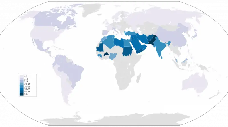
Roughly one in ten marriages globally involves first or second cousins. Pakistan has the highest rate at over 61%, followed by Kuwait and Qatar at around 54%. The practice clusters heavily across the Middle East, North Africa, and South Asia. National averages can be misleading though — in Turkey, rates vary dramatically from province to province, ranging from very high to very low depending on the region. We’ll explore why cousin marriage persists in certain areas, look at the economic and cultural factors behind it, and examine what genetics tells us about consanguinity and inherited conditions.
Read More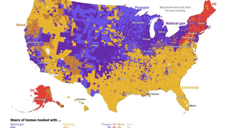
A surprising journey through the hidden world of how Americans stay warm, revealing unexpected connections between energy, landscape, and lifestyle.
Read MorePeople who spent their childhoods in liberal urban and coastal areas are about 10% less likely to get married before
Read MoreAmong the most important factors determining which plants can survive where is how cold the winter is. If you’re planting
Read MoreWhen we examine a United States map showing ethnic majorities at the county level, we uncover fascinating patterns that reflect centuries of migration, settlement, and cultural evolution. From the strong presence of African American majorities in the Southeast to the Hispanic-majority counties in the Southwest, each region tells a unique story of America’s diverse heritage.
Read MoreHere’s Japan, Korea, Russia and China Alaska Western United States and Mexico South America Eastern Europe Northern Europe Western Europe
Read MoreMost Distinctive Causes of Death A. Tuberculosis B. Meningococcal infection C. Septicemia D. Syphilis E. Human immunodeficiency virus F. Other
Read More