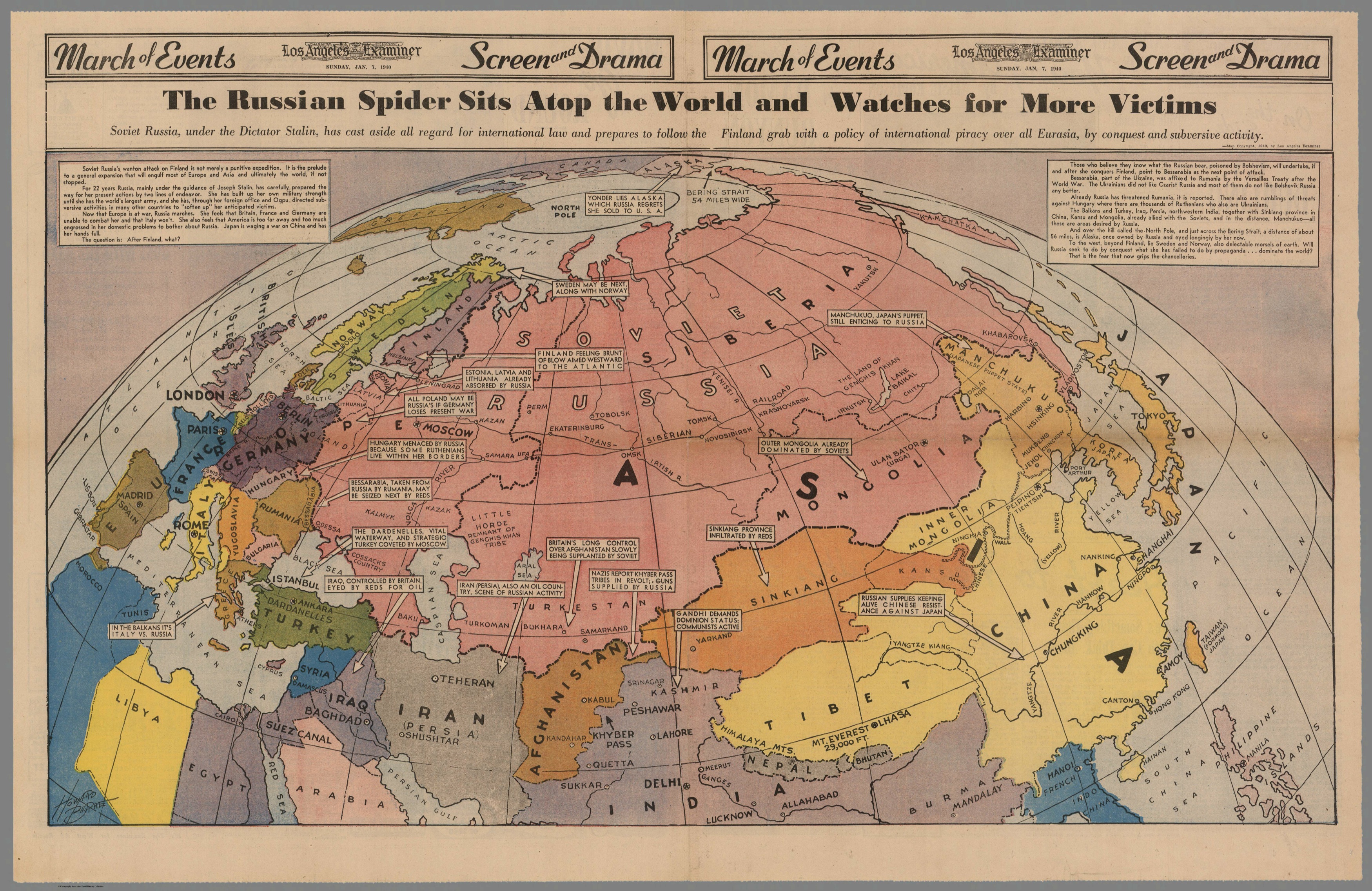
In January 1940, as World War II raged in Europe, the Los Angeles Examiner published a provocative map titled The Russian Spider Sits Atop the World and Watches for More Victims. It depicted the Soviet Union as a sprawling force, ominously positioned to expand its influence across Eurasia. With Stalin’s USSR already engaged in the Winter War against Finland and eyeing Bessarabia, the map amplified fears of communist expansion—a theme that would dominate global politics for decades.
Context: Why Was This Map Created?
At the time of publication, the Soviet Union had just invaded Finland in the Winter War (1939–1940), shocking the world with its aggression. The map’s subtitle warned that Soviet Russia had “cast aside all regard for international law,” suggesting that Finland was just the beginning of Stalin’s territorial ambitions. Western nations, particularly the United States and Britain, were deeply suspicious of Soviet motives, and this map played into those anxieties.
Designed to stir public opinion, the map wasn’t just a geographical representation—it was a statement. The Soviet Union was illustrated in a web-like fashion, with arrows and notes predicting future conquests: Bessarabia, the Balkans, Turkey, Persia (Iran), and even parts of China and India. Over the North Pole, an ominous note pointed toward Alaska, reminding readers that Russia once owned the territory and “eyed it longingly now.”
The Propaganda Factor
Newspapers at the time were powerful tools of influence, and the Los Angeles Examiner—owned by media mogul William Randolph Hearst—was known for its sensationalism. Hearst was a staunch anti-communist. He had long warned of the “Red Menace” and used his papers to shape American public opinion. This map fit neatly into that narrative, portraying the USSR as an insatiable aggressor, even as Nazi Germany posed a far more immediate threat in Europe.
How Accurate Were These Predictions?
Some of the fears outlined in the map were overblown, but others came true:
The USSR did annex Bessarabia (modern-day Moldova) in June 1940.
The Baltic States (Estonia, Latvia, and Lithuania) were occupied and later annexed by the Soviet Union.
After World War II, the Soviet sphere expanded dramatically, bringing much of Eastern Europeunder communist control.
However, other predictions—such as the USSR invading India or Scandinavia—never materialized. While Soviet influence reached deep into Asia, Stalin never launched a direct military campaign for global conquest.
The Map’s Lasting Impact
This map is a fascinating artifact of its time, foreshadowing the Cold War rhetoric that would dominate U.S.-Soviet relations for the next half-century. It serves as an example of how maps can be used not just for navigation, but as political weapons—tools to shape perception and influence public opinion.
Today, it remains a reminder of how geopolitical fears can be amplified through visual storytelling. It also raises questions: How much of our understanding of international conflicts is shaped by media narratives? What maps today might be serving a similar purpose?