The Divided States of Brazil: Exploring Regional Stereotypes Through Humorous Maps
Brazil spans 8.5 million square kilometers and is home to over 212 million people (as of 2024), making it the fifth-largest country in the world both by area and population. With such immense size comes incredible diversity – in climate, culture, cuisine, and socioeconomic conditions. These differences have naturally led to regional stereotypes and playful competitions between different parts of the country.
In recent years, Reddit users have created “stereotype maps” that divide countries according to humorous (and often exaggerated) regional characteristics. These maps, inspired by works like Yanko Tsvetkov’s “Atlas of Prejudice,” (Amazon link) offer a window into how Brazilians see themselves and each other – though they should definitely be taken with a grain of salt!
Twelve ways to divide Brazil
This extensive collection from Reddit user SoldadoTrifaldon provides a comprehensive look at Brazil through various lenses:
- Seasons: From “Wet and Dry” to “Fall, Winter, Spring and Hell”
- Foreign Perception: Contrasting “What people associate with Brazil” versus “What people don’t know about Brazil”
- Ethnicity: Showing “Majoritarily pardo” and “Majoritarily white” regions
- Population Distribution: Half of Brazil’s population lives on the Atlantic coast.
- Wealth: From “Very rich” to “Very poor”
- Existence: “Confirmed” versus “Presumed” regions
- Voting Patterns: From the 2018 election showing Bolsonaro/Haddad support
- Nazism: With the peculiar categories “Not Nazis” and “Deny being Nazis”
- Meat Consumption: From “Rather have fish” to “Churrasco is a way of life”
- 2018 Election Results: Showing Bolsonaro/Haddad support more specifically
- Concerns: Including “River pirates” and “Powerful landowners”
- Favorite Sport: All about soccer (or football, as Brazilians would say)
This collection mixes actual demographic data with satirical observations, providing both humor and insight into Brazilian cultural divides.
Six Ways to Divide Brazil

Taking a more absurdist approach, this collection by Reddit user Mervynhaspeaked divides Brazil into increasingly whimsical categories:
- Existence: Simply “Exist” versus “Still a matter of speculation”
- Population Density: Including a “Dystopian Cyberpunk Mega-City” region
- Cultural Identity: With “100% Brazil” contrasted with “Basically Germany with lots of Italians and Ukrainians” and the truly outlandish “A Martian riding a T-Rex”
- Language Accents: Ranging from “Normal Portuguese” to “Even funnier I kid you not”
- Political Divisions: With regions that “Usually vote for the Left/Right” and the ominous “Don’t ask your grandpa about the 1940s”
- Tourism: The entire country simply labeled as “Wants you to come to Brazil”
These maps blend genuine regional stereotypes with internet humor, creating a uniquely Brazilian take on the country’s diversity.
Six more ways to divide Brazil

Taking satire to another level, this collection explicitly labels itself as an “Atlas of Brazilizn Prejudice.” Created by Reddit user eukubernetes, these maps showcase regional rivalries, food debates (the eternal “rice on top of beans” versus “beans on top of rice” controversy), political divisions, and the universal love of soccer.
The creator acknowledges the provocative nature of these maps with the note: “Yes, I know this isn’t great, but nobody had made this for my country, so here it is.”
Four ways to divide Brazil

Moving from satire to more factual representations, these maps appear to be based on actual demographic and economic data:
- GDP Per Capita: Dividing regions above and below the average of $14,070
- 2018 Presidential Election Results: Showing detailed voting patterns for Bolsonaro and Haddad
- Racial Demographics: Depicting areas with White majority/plurality and Pardo majority/plurality
- Köppen-Geiger Climate Classifications: Showing Tropical, Arid, and Temperate regions
These visualizations highlight real socioeconomic and demographic divisions within Brazil, offering context for some of the stereotypes depicted in the more satirical maps.
South Brazilian Regional Stereotypes
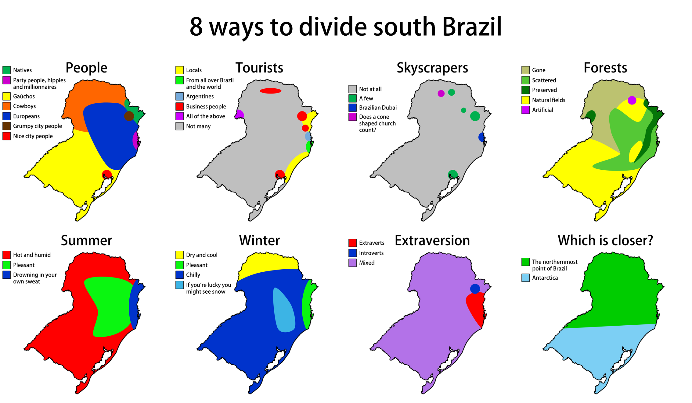
Zooming in on a specific region, this final collection focuses on southern Brazil, which has distinctive cultural and climatic characteristics compared to the rest of the country. These maps divide South Brazil according to:
- People: From “gauchos” and “cowboys” to “party people, hippies and millionaires”
- Tourists: Showing where you might find “business people” versus “Argentines”
- Skyscrapers: Including the amusing category “Does a cone-shaped church count?”
- Forests: From “preserved” areas to “natural fields”
- Summer Climate: With the memorably named “drowning in your own sweat” region
- Winter Climate: Where you might, if lucky, “see snow”
- Extraversion: Simple divisions between “extraverts,” “introverts,” and “mixed”
- Proximity: Comparing distances to the “northernmost point of Brazil” and “Antarctica”
The inclusion of these South Brazil-specific maps highlights how Brazil’s diversity extends beyond the national level to create distinct regional identities even within smaller geographical areas.
Brazil’s True Diversity
While these maps playfully exaggerate regional differences, they reflect a deeper truth about Brazil’s remarkable diversity. The country encompasses everything from dense Amazon rainforest to arid scrubland, from megacities to isolated rural communities, and from some of South America’s wealthiest neighborhoods to areas of significant poverty.
What’s your favorite way to divide Brazil? Have you experienced these regional differences firsthand? Share your thoughts in the comments below!


?")


