The 1920 Plan of The Central European Union
In the early 20th century, particularly during and after World War I, there were discussions and proposals for various forms of European cooperation and unity.
Read More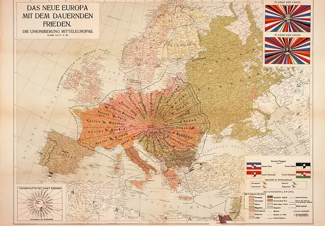
In the early 20th century, particularly during and after World War I, there were discussions and proposals for various forms of European cooperation and unity.
Read More
Today about 7.8 billion people live on our planet. But the population is extremely unevenly distributed. These maps clearly describe the uneven distribution of humans.
Read More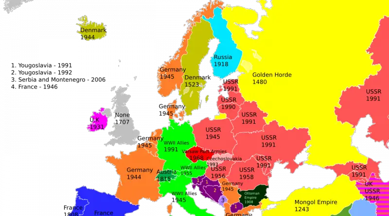
The history of the European continent is mind-blowing complicated. That’s why the borders of many European countries have changed many times.
Read More
The Mediterranean Sea at all times played a significant role in the communication of the peoples around it. The world map shows what a unique position the Mediterranean Sea has in the world. It looks like a closed sea, but it offers the main transit routes linking east and west. All this, along with a beautiful climate and abundant nature, has made the Mediterranean region the cradle of world civilization. The maps below show the uniqueness of the Mediterranean region.
Read More
Atlantropa was a gigantic engineering and colonization idea designed by the German architect Herman Sörgel to unite the continents of Europe and Africa through the partial evaporation of the Mediterranean Sea.
Read More
The breakdown of Russia formed Poland, Finland, Estonia, Latvia Lithuania. The Austro-Hungaria separated into Austria, Czechoslovakia, Hungary, and Yugoslavia. The Ottoman Empire lost much of its territory in the Middle East and southwest Asia. Germany lost considerable territories outside Europe.
Read More
Now that 2019 is almost done, we think it would be interesting to look backward at our most favored maps of the year.
Read More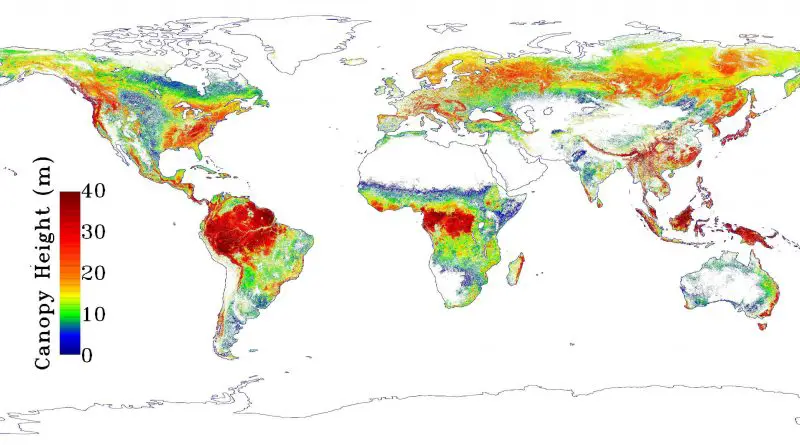
According to the map, forest heights decrease at a higher elevation and are highest at low latitudes, decreasing in height the farther they are from the tropics (except 40° south latitude in southern temperate rainforests in Australia and New Zealand). Moreover, the highest forests are concentrated in mountain areas.
Read More
The maps are based on distance from cities, roads, railways, and airports. The green areas represent places where travel to the city, road and other transportation facilities can be measured in hundreds of kilometers.
Read More
Europe has seen a drop in the intentional homicide rate by 63% since 2002 and by 38% since 1990. Russia and Ukraine reported the highest number of intentional homicide victims per 100 000 inhabitants. The lowest number of intentional homicide victims was recorded in Norway, Italy, and Spain.
Read More