Canada is up north in North America. It’s huge, covering 10 provinces and 3 territories from the Atlantic to the Pacific—the world’s second biggest country! Its southern border with the U.S., extending 5.5 thousand miles or 8.9 thousand kilometers, is the longest international land border in the world.
In the 16th century, British and French explorers settled along the Atlantic coast. Following a series of armed conflicts, France ceded most of its North American territories to Britain in 1763. A hundred years later, in 1867, Canada became a self-governing federation of four provinces, and it gradually evolved toward full independence.
Presently, Canada’s capital city is Ottawa, while Toronto, Montreal, and Vancouver function as significant, dynamic metropolitan centers. It’s the world’s 10th biggest economy, ranking 17th in income per person and 13th in human development.
But how do you really make sense of Canada’s vastness and diversity?
Sometimes, a regular political map doesn’t cut it. That’s where these creative maps come in—funny, exaggerated, but strikingly insightful visualizations that slice and dice the country in ways that reflect culture, climate, language, attitudes, and even regional rivalries. Let’s explore them!
8 ways to divide Canada
This map, created by Reddit user Samwell, isn’t afraid to poke fun. It splits the country in eight totally different ways—from temperature zones (“Pluto” cold?) to language groups, from who actually wants to be part of Canada (ouch) to political alignment. Then come the truly subjective divisions, like personality types and stereotypes ranging from “enlightened freethinker” to “primitive fat-eater.”
It’s tongue-in-cheek, but beneath the humor lies something real: the tension between east and west, north and south, English and French, rural and urban. These divisions reflect not just how Canada is, but how it feels depending on who you ask.
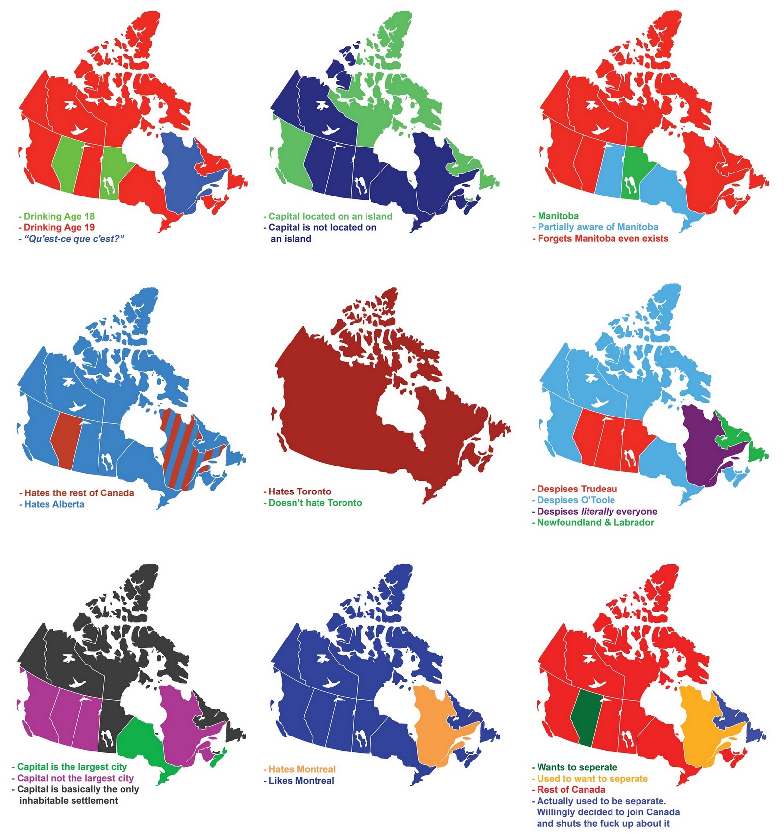
9 Ways To Divide Canada
From time zones to alcohol consumption, religion, sports fandom, and even vegetarianism, this map explores nine unique lenses through which Canada can be split. Each of these divisions highlights a different facet of Canadian identity.
Reddit user: Diogenedarvida
9 Ways To Divide British Columbia
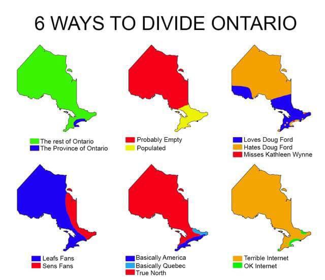
Ontario often gets framed as “Toronto vs. everyone else.” But this map gives it more nuance, dividing the province along lines of economy, politics, sports, and even regional resentment.
Whether you’re from the urban south, the mining-heavy north, or the Ottawa Valley, there’s something to relate to. It’s a fun way to see just how complex a single province can be—and how geography and culture intersect in surprising ways.
6 ways to divide Ontario
B.C. is as geographically diverse as it is culturally layered. The map below shows everything from mountain people and wine lovers to Vancouver’s hipsters and Victoria’s retirees. It’s a province with rainforest coasts, desert-like valleys, and alpine peaks—and a population just as varied.
Whether it’s the free spirits of Nelson or the oil workers of Fort St. John, this map captures the distinct vibes that make British Columbia both fascinating and famously hard to govern from a single central mindset.
If you were to divide Canada your own way, how would you draw the lines? Based on food? Weather? TikTok trends? Political rants? Drop your thoughts below.