United States Elevation
The United States is a vast and geographically diverse country with a wide range of elevations, topographical features, and landscapes. It spans from the Atlantic Ocean in the east to the Pacific Ocean in the west and from the Gulf of Mexico in the south to the Canadian border in the north. This extensive territory encompasses a variety of elevation levels, from low-lying coastal areas to towering mountain ranges.
In the eastern part of the United States, the elevation tends to be relatively lower, with much of the land at or near sea level. The Atlantic coastal plains, for example, are characterized by flat or gently rolling terrain. As you move inland, there are modest elevations in the Appalachian Mountains, which run along the eastern edge of the country. These mountains are not as towering as the western ranges, but still offer some rugged terrain.
The western United States, on the other hand, features a much more dramatic variation in elevation. The Rocky Mountains and the Sierra Nevada Mountains are prominent features in the western half of the country, with numerous peaks rising well over 10,000 feet (3,048 meters) above sea level. The highest point in the contiguous United States is Mount Whitney in California, which stands at 14,505 feet (4,421 meters). The Rockies extend from the northern border of New Mexico all the way up into Canada, forming a significant portion of the country’s western elevation.
In addition to mountainous regions, the western United States also contains high plateaus and deserts. The Colorado Plateau, for instance, includes areas with an elevation of several thousand feet, marked by deep canyons and unique geological formations like the Grand Canyon. Meanwhile, the deserts, such as the Sonoran and Mojave Deserts, feature low-lying basins with elevations varying from below sea level to several thousand feet above it.
The United States also boasts a variety of other geographical features, including the Great Plains, which stretch across the central part of the country and have a relatively low, rolling elevation compared to the mountains on either side. Moreover, Alaska, the largest state in the country, is home to some of the most towering peaks in North America, including Denali (formerly known as Mount McKinley), which reaches 20,310 feet (6,194 meters) above sea level.
The atlas of maps below clearly represents the main landforms of the United States of America.
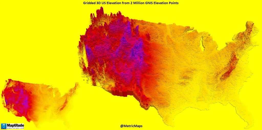
3D United States Elevation
Gridded 3D US elevation from 2 million GNIS elevation points.
The highest point in each U.S. state
There are 73,318 named mounts in the United States. The three primary mountain chains of the United States are the Appalachian Mountains, the Rocky Mountains, and the Sierra Nevada.
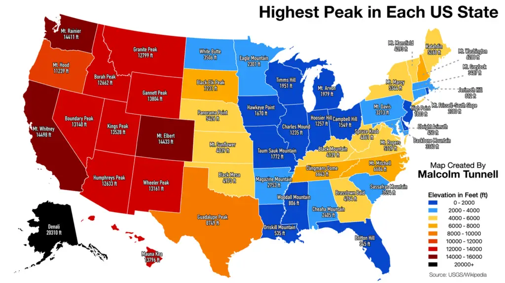
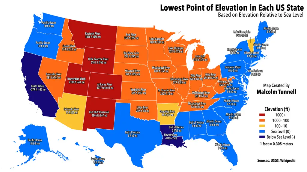
While, the highest point in the U.S. is Denali (Alaska) at 20 320 feet (6 194 m) above sea level, the lowest point on land in the U.S. is Badwater in Death Valley (California) at 282 feet (86 m) below sea level.
The map of the United States below depicts the lowest point in every state.
Lowest Point of Elevation in Each U.S. States
Below is the map of the Highest and lowest natural elevation in every US county created by Reddit user DarkerThanAzure.
Map of the Highest and Lowest natural elevation in every US county

Key facts
- The highest point in the United States is Denali (Alaska) at 20 320 feet (6 194 m) above sea level. The lowest point on land in the United States is Badwater in Death Valley (California) at 282 feet (86 m) below sea level.
- Colorado, with the highest mean elevation of any state as well as the highest low point, is the “highest state”.
- Florida has the lowest high point, and Delaware has the lowest mean elevation. Florida is also the flattest state, with the smallest difference between its highest and lowest points.
- The map below shows the highest point in every U.S. state.



Nice breakdown, I’m always fascinated by the vast variance in topography throughout the U.S.
cool