The Largest Community in Each Time Zone on New Year’s Day
New Year’s begins on Kiritimati with just 3,547 in that zone, then moves west to reach everyone
Read More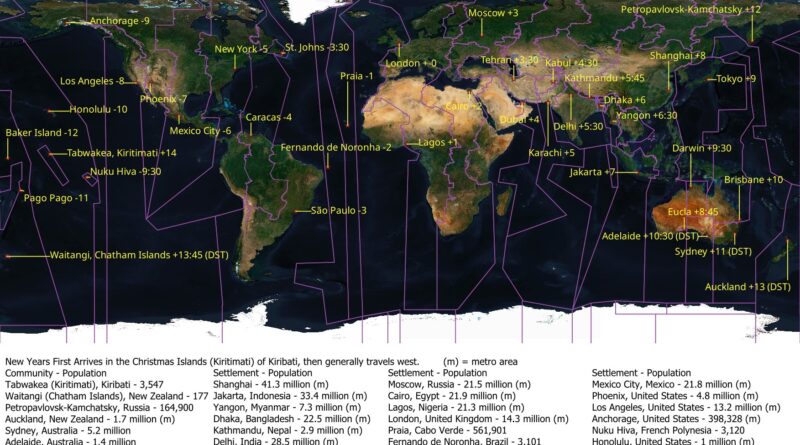
New Year’s begins on Kiritimati with just 3,547 in that zone, then moves west to reach everyone
Read More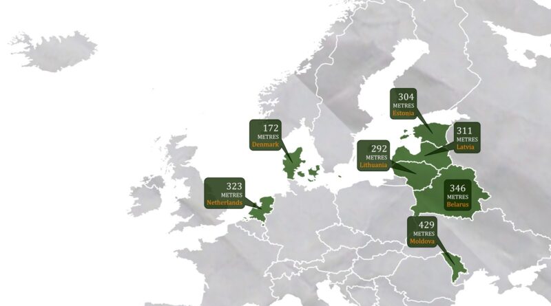
Mountains cover about 35% of Europe, but seven countries remain remarkably flat. Denmark’s highest point barely exceeds 170 meters, while Moldova tops out at 429 meters. These nations share a geological heritage of tectonic stability and glacial smoothing, resulting in landscapes of gentle plains rather than dramatic peaks.
Read More
From the Himalayas to the Andes, some countries live life in the clouds—literally. This post maps the highest countries on Earth and their tallest points, revealing how altitude impacts agriculture, tourism, and even health.
Read More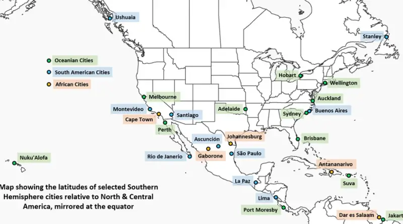
A fascinating look at how cities in North & Central America line up with their Southern Hemisphere counterparts, revealing surprising geographic parallels and climate patterns.
Read More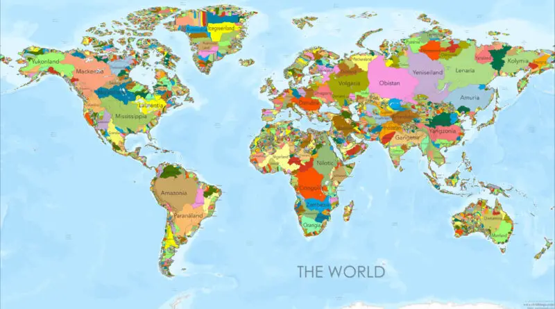
I’ve spent years drawing maps and staring at political boundaries, always wondering: what if we threw out those arbitrary lines and started over? What if, instead of following the legacy of colonial empires and ancient wars, our borders traced something more fundamental—the flow of water itself? That question led me to create a series of world maps that reimagine our planet as a collection of river basins, each “country” following the natural watershed of a major river system.
Read More
The equator and the prime meridian are two significant lines of latitude and longitude that intersect the Earth, dividing it into the Northern and Southern Hemispheres, and the Eastern and Western Hemispheres, respectively. Countries that lie on the equator experience a tropical climate and have unique flora and fauna. These countries often face challenges such as high temperatures, humidity, and rainfall, but they also boast rich biodiversity and natural resources.
Read More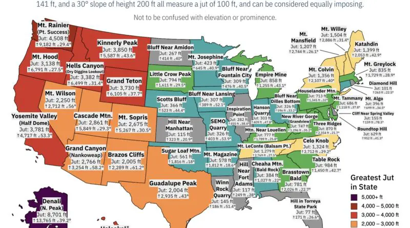
The impressiveness of mountains and other landforms is inherently subjective. Regardless, two factors that universally contribute to the perceived impressiveness of a landform are its height and steepness. Height is a significant factor in defining impressiveness, but it’s not the only factor. For example, even though Mt. Elbert in Colorado (elevation: 4,399 meters or 14,432 ft) has a higher elevation than Grand Teton in Wyoming (elevation: 4199 meters or 13,776 ft), mountaineers can attest to Grand Teton looking considerably more impressive, as it rises much more steeply over the local landscape.
Read More
A mountain range is a series of mountains arranged in a line and connected by high ground. Mountain ranges are formed by a variety of geological processes, but most of the substantial ones on our planet are the result of plate tectonics. Mountain ranges that have arisen from the same cause and are similar in form, structure, and alignment make up a mountain system.
Read MoreComparing the land masses of European countries to approximate North American state equivalents provides insights into the size and geographical scale of these regions.
Read More
The border between Europe and Asia is exceptional among continental boundaries because there is no significant physical distinction between the two continents except rivers and mountains east and north of the Black Sea. This boundary has been altered many times throughout history.
Read More