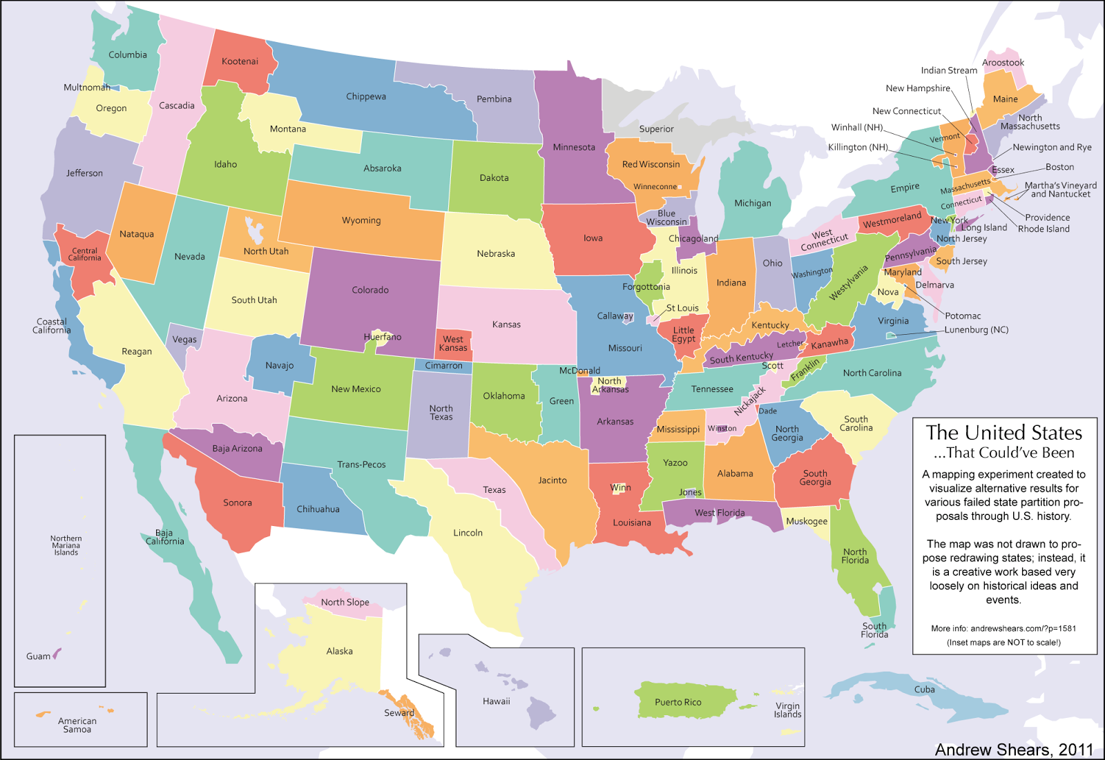
Have you ever wondered what the United States map might look like if history had taken a different turn? A fascinating creation by Reddit user sbfromsf offers a captivating glimpse into an alternate reality where various breakaway plans and state partition proposals throughout U.S. history actually succeeded.
The map above shows what the US could have looked like if all the various breakaway plans had worked out. The original blog post by Andrew is no longer up, but the concept continues to spark imagination and debate.
Exploring the Alternate United States
This reimagined map of the United States is a testament to the power of “what if” scenarios in history. It visualizes a country where state boundaries have been redrawn based on various historical proposals for new states, secessions, and territorial reorganizations.
Some notable features of this alternative United States map include:
New England Reconfigured: The map shows a dramatically altered New England, with states like Vermont and New Hampshire taking on different shapes and sizes.
The Great Lakes Region: This area sees significant changes, with new states carved out of what we know today, such as Michigan, Wisconsin, and Minnesota.
The South Reimagined: The Southern states underwent substantial reorganization, reflecting various partition proposals from the Civil War era and beyond.
Western Frontiers: The map depicts numerous new states in the West, showcasing how the frontier might have been settled and divided differently.
Cascadia Controversy: One of the most debated aspects of this map is the location and naming of “Cascadia.” Many observers have pointed out that the area labeled as Cascadia doesn’t align with the common conception of the Cascadian identity, both culturally and geographically. The region depicted doesn’t include much of the Cascade mountain range, which is central to the Cascadia concept.
The Fascination with Alternative History
This map taps into a long-standing fascination with alternative history. From literature to pop culture, the idea of “what might have been” has captivated imaginations for generations. Books like Philip K. Dick’s “The Man in the High Castle” or Harry Turtledove‘s extensive works on alternative Civil War outcomes have shown how a single change in history can lead to drastically different worlds.
For those interested in exploring this topic further, here are some recommended reads:
Maps like this alternative United States version do more than just redraw boundaries; they tell stories. They invite us to question the nature of our national identity, the arbitrariness of borders, and the complex interplay of geography, politics, and culture that shapes our world.
While this map is a work of fiction, it serves as a powerful tool for understanding the real United States. By examining what could have been, we gain a deeper appreciation for the historical processes and decisions that led to the country we know today.
Whether you’re a history buff, a geography enthusiast, or simply someone who enjoys pondering “what if” scenarios, this alternative United States map offers a fascinating journey through a country that never was, but easily could have been.
Remember, the next time you look at a standard United States map, that the familiar shapes and lines we take for granted are the result of countless historical twists and turns. In an alternate timeline, you might be living in a state with a very different name and shape!
What alternate state would you have found yourself in? Share your thoughts in the comments below!