Have you ever wondered what the world looked like during the last ice age?
The Last Glacial Maximum, commonly known as the last ice age, took place approximately 26,000 to 19,000 years ago.
During that time period, the climate was characterized by cold and dry conditions, with temperatures that were, on average, 6°C (11°F) lower than today.
The sea level worldwide was over 400 feet (122 meters) below the current level, and glaciers extended over about 8% of the planet’s surface, which is equivalent to 25% of the total land area.
During the peak of this recent glaciation, sheets of ice spread across Canada, Scandinavia, Russia, and South America, reaching thicknesses of over 12,000 feet (3.7 kilometers).
It happened because, in an ice age, ocean water that evaporates gets stored on land as large ice sheets, ice caps, and glaciers. This causes a significant drop in sea levels, as the water does not return to the ocean.
| Our Planet’s Ice Cover | 20,000 Years Ago | Present |
|---|---|---|
| Surface | 8% | 8% |
| Land | 25% | 11% |
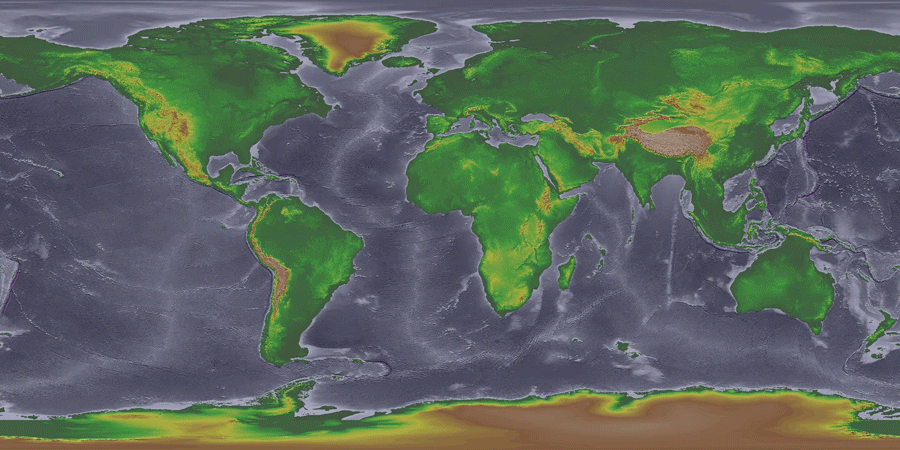
Mapmaker Perrin Remonté created the map to give us a look into the Earth from that time, compiling sea levels and glaciers from modern research with new topographical data.

Because the sea level was much lower during the glacial sea than it is now, large areas of the continental shelf were exposed.
These areas are marked in gray on the map. The largest areas of dry land can be found in Europe, Southeast Asia, as well as between Russia and Alaska:
- Beringia: This land bridge connected present-day Siberia (Russia) with Alaska (United States). It was a vast expanse of land that emerged as a result of the lower sea levels caused by the extensive glaciation. Beringia provided a route for human migration from Asia to the Americas.
- Doggerland: Located in the North Sea, Doggerland was a massive landmass that connected the British Isles with mainland Europe. It was gradually submerged by rising sea levels around 6,500 BCE, and its existence was only confirmed in recent times through geological and archaeological studies.
- Sundaland: Sundaland was a large landmass that included the present-day islands of Borneo, Java, Sumatra, and their surrounding areas. During the Ice Age, when sea levels were significantly lower, these islands were connected by land, creating a vast region for flora, fauna, and human populations.
- Sahul: Sahul was a supercontinent that included present-day Australia, New Guinea, and the Aru Islands. During the Ice Age, when sea levels were much lower, Australia and New Guinea were connected by land, allowing humans and animals to migrate between them.
A simplified map of sea level during the ice age is as follows.
During the Ice Age, the Earth’s climate zones were shifted compared to the present-day distribution. The colder temperatures and the presence of massive ice sheets and glaciers influenced the formation and distribution of various climatic zones.
The polar regions, including the Arctic and Antarctic, experienced an expansion of ice sheets and glaciers during the Ice Age. These regions were characterized by extremely cold temperatures and vast ice-covered landscapes.
The subpolar regions were located just south of the polar zones. These areas also experienced cold climates but were generally milder compared to the polar regions. Subpolar zones supported tundra and boreal forest ecosystems.
The temperate zones were situated at lower latitudes than the subpolar regions. These areas had relatively milder climates and experienced greater seasonal variations. The temperate zones supported a mix of deciduous and evergreen forests, woodlands, and grasslands.
The Mediterranean zones, located in southern Europe and parts of North Africa, experienced mild winters and hot, dry summers. These regions were characterized by vegetation such as scrublands, shrubs, and drought-resistant plants.
Steppes, or grassy plains, existed in drier regions of Europe and Asia. These areas had less precipitation compared to the temperate zones and were characterized by grasslands with scattered shrubs and herbaceous vegetation.
Mountainous regions had their own unique climatic zones, influenced by elevation and topography. Higher elevations experienced cooler temperatures, and the presence of mountains allowed for the development of unique microclimates and ecosystems.

