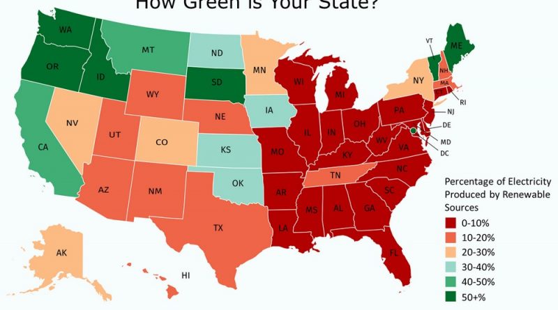
Where palm trees are found in the United States
Uncover the hidden diversity of palm trees native to the United States, from Florida’s lush landscapes to the unique ecosystems that support these remarkable plants.
Read MoreMaps depicting environmental degradation across planet.
Uncover the hidden diversity of palm trees native to the United States, from Florida’s lush landscapes to the unique ecosystems that support these remarkable plants.
Read MoreWhat do maps reveal about fatal bear attacks in North America? Dive into patterns, bear species’ behavior, and practical safety advice for outdoor enthusiasts.
Read MoreClimate change is projected to have vastly different economic impacts across U.S. states and counties, with coastal regions facing the heaviest financial burden. Florida and Texas each face potential GDP losses exceeding $100 billion, while states like Vermont and New Hampshire show minimal projected impacts. The analysis reveals that lower-income counties often bear a disproportionate burden of climate-related economic damage, highlighting the need for equitable adaptation policies.
Read MoreAnimals make some of the most incredible journeys on Earth. A falcon flying 10,000 km in 42 days? An Arctic fox walking across sea ice to another continent? Explore these epic migrations through detailed maps and fascinating facts.
Read MoreThe world’s truly wild landscapes are vanishing. But some places still remain largely untouched. Where are they? What wildlife do they shelter? And how fast are they disappearing? Explore the Last of the Wild map and find out.
Read MoreHow do forests and human settlements coexist? This article explores tree cover distribution, deforestation trends, and the patterns revealed by global maps.
Read MoreRivers across the western U.S. are vanishing—140,000 miles of them have been rerouted, dammed, or dried up. This post looks at what’s behind the loss, which states are hardest hit, and how maps can help us understand what’s at stake.
Read MoreDiscover how the Dutch protect one‑third of their country below sea level. This post covers Rijkswaterstaat’s role, key movable barriers, dunes, dikes, and climate‑future plans—with a detailed map we made using Rijkswaterstaat open data and elevation models.
Read MoreCO2 is the most significant long-lived greenhouse gas in the Earth’s atmosphere. Since the Industrial Revolution, anthropogenic emissions – primarily
Read MoreOnly 5% of global landmass remains untouched by human activity. These maps show uninhabited areas across nine countries, plus global wilderness zones with minimal human footprint. Even in densely populated Netherlands, green spaces persist where no one lives.
Read More