South Korean presidential election results (2017)
Reddit user: mmaronn
Read MorePolitical Maps show governmental and administrative borders of countries, provinces, states, and counties, the location of major cities, and other political units.

Reddit user: mmaronn
Read MoreA time lapse animation mapping the 200-year evolution of governmental systems around the world, & the overall shift toward democracy.
Read MoreDreams of radical nationalists in Eastern and Central Europe. Source: magazyn.wp.pl Related posts: – Active separatist movements in Europe – Hypothetical map
Read MoreReddit user: DoctorWinstonOBoogie Source: nytimes.com French Election: Final Results by Department (Both Rounds), 2017 Related posts: – French Presidential Election
Read More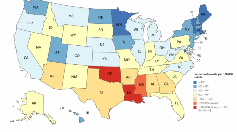
Most prisoners are in Louisiana, Oklahoma and Mississippi. Reddit user: whiplashoo21 Louisiana is the world’s prison capital. Louisiana’s incarceration rate is nearly
Read More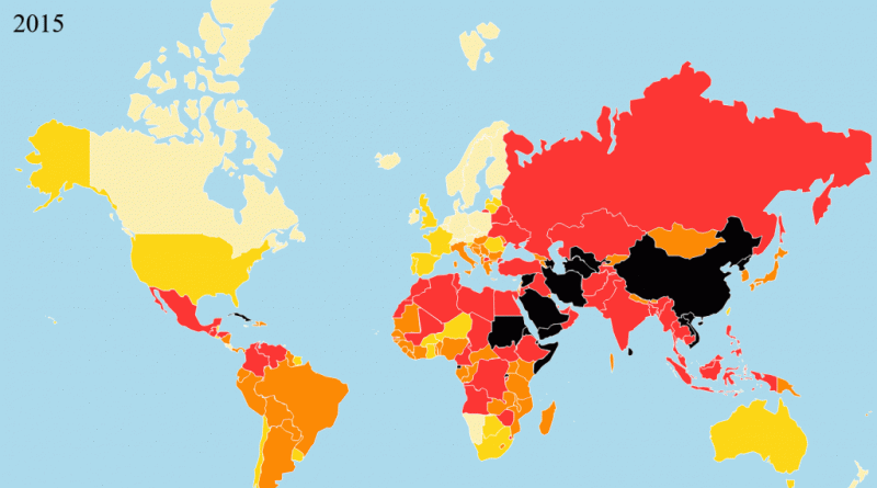
Indicators:1.Pluralism (Measures the degree to which opinions are represented in the media).2. Media independence (Measures the degree to which the
Read MoreEmmanuel Macron (24.01%) Marine LePen (21.3%) François Fillon (20.01%) Reddit user: hypersite Jean-Luc Melenchon (19.58%) Related posts: – French Presidential Election
Read MorePercent of respondents who considering the countries listed below to be an enemy of the United States. Source: forbes.com Source:
Read MoreElection results for the first round of the 2017 French presidential election, shown by commune (town). Colors were chosen based
Read MoreSource: slate.fr Related post: – French Presidential Election (2017)
Read More