Central Europe is a bit of a moving target – it shifts with each perspective. As a Prague think tank notes, the region is “a transition zone” with “no fixed boundaries or definitions”. In other words, unlike a country or continent, no treaty or organization has ever chalked a single outline around it. Every historian, geographer or policymaker seems to have their own pen. The notion of “Central Europe” is more like a patchwork of histories and cultures than a rigid shape. Try pinpointing it on a map, and you’ll discover just how many lines people can draw.
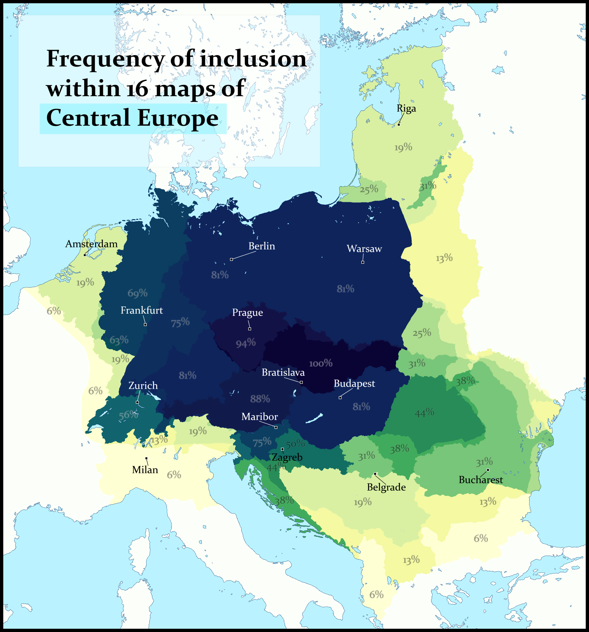
Reddit user u/Timely-Macaron268 overlaid the outlines from 16 different sources into one heatmap. Instead of choosing a single answer, the map simply counts how often each area was marked as “Central Europe.”
Darker shades on the map below mean that region shows up in nearly all definitions, while paler shades mean only a few. This approach doesn’t preach one authority – it lets the data speak in color.
The darkest spot (100%) is Moravia in eastern Czechia – literally every map included it. Slovakia comes in at 94% (one map accidentally forgot to color it) and the rest of Czechia isn’t far behind. Austria, Hungary and Poland also light up almost every time. In fact, experts often identify the Visegrád Four (Czechia, Slovakia, Hungary, Poland) as the traditional core, and our heatmap agrees.
Region/Country
Inclusion Frequency
Czechia
94-100%
Slovakia
94%
Austria (most areas)
81-88%
Poland (most areas)
81%
Hungary (most areas)
81%
Germany (central and eastern parts)
69-81%
Slovenia
75%
Switzerland
56%
Croatia
44-50%
Romania
31-44%
Baltic States
19-31%
France (eastern edge)
6-19%
Italy (northern regions)
6-19%
Why all this disagreement? Some definitions of “Central Europe” follow the borders of old empires (think of Habsburgs and Austro-Hungary). Others follow culture, language or religion lines. Still others use modern administrative groupings. For example, the EU’s Interreg CENTRAL EUROPE programme explicitly defines Central Europe as nine specific countries – Austria, Croatia, Czechia, Germany, Hungary, Italy, Poland, Slovakia and Slovenia.
In short, there’s no single rulebook. One atlas might highlight heritage, another modern alliances, yet another language families. Each choice shifts the outline.