The Art of Mockery: Satirical Map Posters of Europe Through Time
The tradition of turning maps into political cartoons dates back centuries, but it reached its golden age during Europe’s most turbulent periods. These satirical map posters of Europe did more than just entertain – they captured the essence of international relations and territorial tensions in ways that words alone never could.
In the 19th century, map makers weren’t just marking territories – they were telling stories. The British Museum’s collection showcases how cartographers merged geography with political commentary, creating pieces that spoke volumes about international tensions.

A striking example comes from 1856 – a British satirical map poster that emerged in the aftermath of the Crimean War. The artist cleverly transformed Russia into an imposing crowned bear, with its teeth firmly gripping Crimean territory. The bear sits constrained by a heavy chain, symbolizing the limitations imposed on Russian expansion following their defeat – a detail that The British Library notes was a common motif in post-war political cartography.
What makes this map particularly fascinating is its portrayal of Austria-Hungary as a two-headed unicorn – an ingenious visual metaphor for the empire’s dual monarchy system. Each head represents one half of the empire: the Austrian Empire and the Kingdom of Hungary. According to the Journal of Historical Geography‘s analysis of 19th-century political cartoons, this may be one of the earliest instances of using mythological creatures to represent European powers in map art.

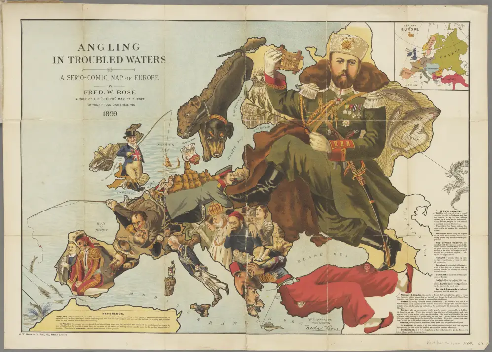
Fast forward to 1914, and we see another masterpiece of cartographic satire. This map poster of Europe captures the powder keg of pre-WWI tensions, with each nation represented by distinctive characters that reflected their perceived roles in the coming conflict.
Contemporary artist David Cartoons (@DaveyCartoons on Twitter) has brilliantly revived this tradition for our modern era. His work proves that while centuries pass, the power of satirical maps endures.

In his 2016 interpretation, Cartoons depicts a Europe grappling with familiar challenges. The Russian bear, now sporting an ushanka hat, reaches toward Crimea – a stark parallel to the 1856 version. The addition of Trump’s wind-blowing visage represents America’s growing influence on European affairs.

The 2018 “Serio-comic map of Europe” takes inspiration from Renaissance cartographic elements while addressing contemporary issues. The Putin-esque visage looming over Eastern Europe, with bombs disguised as drool falling on Syria, demonstrates how modern artists can adapt classical satirical techniques to current events.
For those interested in decorating their spaces with historical or contemporary map posters of Europe, here are some carefully curated options available on Amazon:
- Vintage European Map Poster
- Modern Political Map of Europe
- Historical Map Collection – Europe Through Ages
These map posters serve as both stunning wall art and conversation starters, offering glimpses into how different generations viewed European politics and power dynamics.
Have you noticed how these satirical maps reflect the recurring themes in European politics? Share your thoughts in the comments below.


Fix your effing links. Satirical map collection leads me to ‘how many hours of sunlight’ a subject i am know about and am profoundly uninterested in.
Thanks. Fixed.