Skip to content
VividMaps

  • Atlases
  • Map Posters
  • Scratch Maps
  • Globes
  • Videos
Political maps
June 24, 2015 Alex

Favorability of U.S. and China by country

U.S. seen more positively than China in Africa, Europe, Latin America, but not in Middle East.

Read more: Favorability of U.S. and China by country →

Migration mapsPolitical mapsWorld
June 24, 2015 Alex

The flight of refugees around the globe

Nearly 60 million people are displaced around the world because of conflict and persecution, the largest number ever recorded by

Read more: The flight of refugees around the globe →
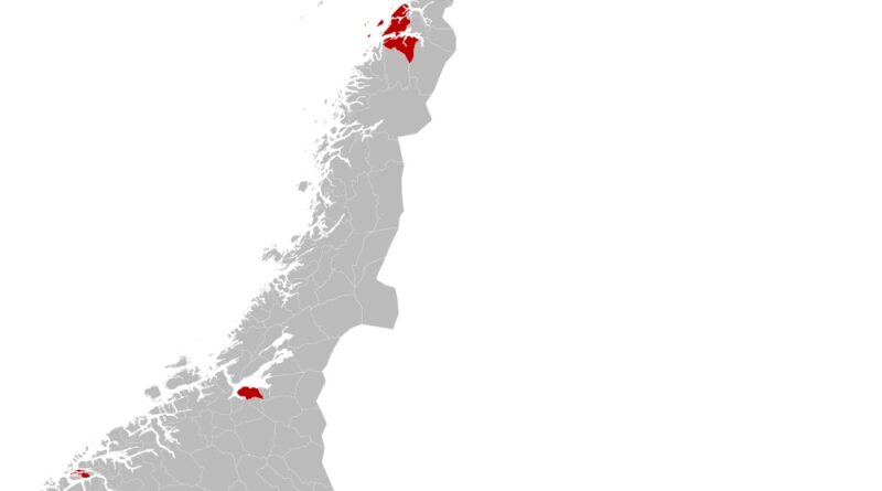
50% of Norway lives in the red area
Population
June 24, 2015 Alex

50% of Norway lives in the red area

Although Norway covers a huge stretch of northern Europe, more than 50% of its people live in a small red-shaded area. Cities like Oslo, Bergen, and Trondheim are growing, while rural municipalities are holding steady or shrinking.

Read more: 50% of Norway lives in the red area →
Demography
June 24, 2015 Alex

Child mortality is decreasing throughout Africa

Via www.ourworldindata.org

Read more: Child mortality is decreasing throughout Africa →
June 24, 2015 Alex

Media Markets Area Racism

Via plos.org

Read more: Media Markets Area Racism →
LanguagesWorld
June 23, 2015 Alex

Where English is an Official Language

Read more: Where English is an Official Language →
Historical Maps
June 23, 2015 Alex

Areas of Finland

Read more: Areas of Finland →
World
June 23, 2015 Alex

What’s on the other side of the Earth?

Read more: What’s on the other side of the Earth? →
Population
June 23, 2015 Alex

Population change from 2001 to 2011

Red – increase. Blue – decrease.

Read more: Population change from 2001 to 2011 →
Economic mapsWorld
June 23, 2015 Alex

Population Employment Ratio by Country

Read more: Population Employment Ratio by Country →
Economic mapsGISSociologyWorld
June 23, 2015 Alex

Socio-economic tectonics

Borders are scaled to show a ratio of dissimilarity. The line thickness is a ratio calculated between adjacent countries. Countries

Read more: Socio-economic tectonics →
Population
June 23, 2015 Alex

50% of Colombians live in these municipalities

Read more: 50% of Colombians live in these municipalities →
MapsTransportWorld
June 23, 2015 Alex

How long it takes to travel to the nearest city (> 50,000 people)

Read more: How long it takes to travel to the nearest city (> 50,000 people) →
Page 486 of 521« First«...482483484485486487488489490...»Last »

Trending now

  • Human races of the 19th century
    How Has Our View of Human Diversity Changed Since the 19th Century?Oct 22, 2017
  • Most popular social network
    Most Popular Social App by U.S. StateAug 9, 2019
  • Shifting position of the North magnetic pole mapped
    Tracing the Dance of Earth’s Magnetic North: A Journey Through TimeMar 3, 2025

Related Products

  • Push pin maps
  • Globe drinks cabinets
  • Maps of the United States
  • Board games
  • Monopoly
  • Map-based strategy board games
  • History Board Games
  • Coloring Books
  • Handheld GPS
  • GPS Watches
  • GPS Trackers

Vivid Maps Tools

  • Convert Latitude/Longitude
  • Elevation Finder
  • Distance Calculator
  • Kilometers to Miles Distance & Length Converter
  • Weight Converter
  • Volume Converter
  • Daylight Comparison
  • Time Zone Converter
  • Antipodes Map
  • Find cities with a similar climate
  • Find cities with a similar climate (2050)
  • How hot cities could be in 2050
  • The U.S. Population Lines

Stay connected

Get the latest maps, insights and updates delivered to your inbox.

Unsubscribe anytime.

VividMaps

Maps that explain the world.

Beautiful, data-rich maps to help you understand our world — its people, places and connections.

Explore

World map World atlas Map posters Globes

Company

About Privacy Contact

Stay connected

Follow us for the latest maps, insights and updates.

Independent WebsiteVirusScanner trust report for vividmaps.com
© 2026 Vivid Maps. All rights reserved.
A more connected world