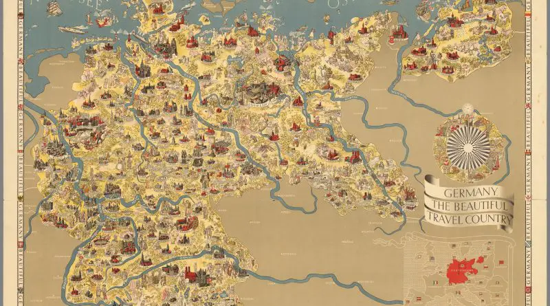
Skip to content
Vivid Maps Logo

  • Atlases
  • Map Posters
  • Scratch Maps
  • Globes
  • Videos
World map: All Ice on Earth Melted
Climate ChangeEnvironment mapsNewsVivid maps

When All the Ice Melts — and When the Oceans Disappear

September 9, 2025 Alex
Global Coffee Arabica Cultivation Mapped
AgricultureNewsVivid maps

From Highland Peaks to Lowland Valleys: Mapping the World’s Coffee and Tea Territories

August 19, 2025 Alex
Mapped Wheat Maize and Rice production
AgricultureNewsVivid maps

Wheat, Maize, and Rice: Mapping the Crops That Feed the World

August 15, 2025 Alex
World map: All Ice on Earth Melted
Climate ChangeEnvironment mapsNewsVivid maps

When All the Ice Melts — and When the Oceans Disappear

September 9, 2025 Alex
Mapped: Where the folk belief of the "Evil Eye" is common
Cultural cartography

Why So Many Cultures Still Fear the “Evil Eye”

August 25, 2025 Alex
Global Coffee Arabica Cultivation Mapped
AgricultureNewsVivid maps

From Highland Peaks to Lowland Valleys: Mapping the World’s Coffee and Tea Territories

August 19, 2025 Alex
Mapped Wheat Maize and Rice production
AgricultureNewsVivid maps

Wheat, Maize, and Rice: Mapping the Crops That Feed the World

August 15, 2025 Alex
ClimateNewsVivid maps
May 22, 2018 Alex

What is the largest country in the world based on the most suitable land area for human habitation?

By analyzing climate conditions and settlement patterns worldwide, this study shows which countries offer the most land area suitable for comfortable human habitation, with Brazil leading the list.

Read More
Number of offences per 10,000 drivers
Laws
May 21, 2018 Alex

The worst drivers in the United Kingdom

From police force areas to regional statistics, this analysis shows how driving offenses have evolved across the UK, with striking differences between urban and rural areas.

Read More
The Progress of the Union Armies
Old maps
May 20, 2018 Alex

A Powerful Message in Black and White: The 1863 “Progress of the Union Armies” Broadside

Analysis of a remarkable 1863 Civil War propaganda broadside featuring an influential persuasive map that demonstrated Union territorial gains to boost Northern morale during a pivotal moment in the conflict.

Read More
Sociology
May 20, 2018 Alex

Gun ownership in the United States

An in-depth look at America’s unique relationship with firearms, analyzing ownership patterns across states and comparing them to global statistics. With over 393 million civilian-owned firearms, the US leads the world in gun ownership – but the rates vary dramatically by state.

Read More
Medeival trade routes
Historical Maps
May 19, 2018 Alex

Medieval Trade Networks

Medieval trade networks were a crucial aspect of the global economy during the Middle Ages, connecting different regions of the

Read More
Old maps
May 19, 2018 Alex

“Chart of part of the South Sea” (1770): A Landmark in Pacific Ocean Mapping

Step into the world of 18th-century exploration with this revolutionary 1770 chart of the South Sea – the first published map to show Australia’s eastern coastline and New Zealand’s complete outline. Created during Captain Cook’s first voyage, this remarkable document changed our understanding of the Pacific Ocean forever.

Read More
A map made in 1500s Jerusalem
Old maps
May 18, 2018 Alex

The Bünting Cloverleaf Map: When Jerusalem Was the Center of the World

In the late 16th century, German theologian Heinrich Bünting created an extraordinary map that reimagined the world as a three-leaf clover with Jerusalem at its heart. This unusual map tells us much about how people viewed the world through a religious lens during the Renaissance period.

Read More
Farms in Europe
Agriculture
May 16, 2018 Alex

The Geography of Pig Farming: Mapping Europe’s Major Production Regions

From Brittany to Catalonia, pig farming remains a crucial part of Europe’s agricultural economy. See which regions lead this important industry.

Read More
Size of Texas
Economic mapsSize comparison maps
May 15, 2018 Alex

How Big Is Texas?

The story of Texas’s size is as fascinating as its history. Journey with us through time to understand how this massive territory transformed from a colonial possession to one of America’s largest and most powerful states.

Read More
Cities with a population of 100k by U.S. state
Cities
May 15, 2018 Alex

How Many Cities with a Population of 100k+ does Each U.S. State Have?

Have you ever wondered how many large cities are in each U.S. state? From the bustling metropolises of California to the smaller yet significant urban centers scattered across the country, the distribution of cities with a population of over 100,000 can reveal interesting insights into the demographic landscape of the United States.

Read More
Page 98 of 674« First«...102030...96979899100...110120130...»Last »

Trending now

  • The Price of Sex around the World Mapped
  • World map: All Ice on Earth Melted
    When All the Ice Melts — and When the Oceans Disappear

Related Products

Push pin maps · Globe drinks cabinets · Maps of the United States · Board games · Monopoly · Map-based strategy board games · History Board Games · Coloring Books · Handheld GPS · GPS Watches · GPS Trackers

Vivid Maps Tools

· Convert Latitude/Longitude
· Elevation Finder
· Distance Calculator
· Kilometers to Miles Converter
· Kilograms to Pounds Converter
· Liters to Gallons Converter
· Temperature Converter
· Find cities with a similar climate
· Find cities with a similar climate (2050)
· How hot cities could be in 2050
· The U.S. Population Lines

About
Privacy Policy

Copyright © 2025 Vivid Maps. All rights reserved.