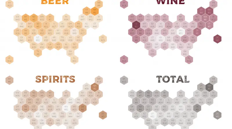
United States

Maps of the US

Climate

The ‘White Christmas Map’ Reveals Every Country’s Chance of Snow on Christmas Day – and Every State too…

New research based on the last 9 years of December snowfall Russia (63.1%), Belarus (55.6%), Estonia (50.9%), and Lithuania (50.2%) officially lead the way when it comes to the odds of seeing a White Christmas. Back in the US, Alaska (62.8%), Vermont (52.3%), and Minnesota (36.9%) top the list, leaving the others in the dust (Arizona, California, Florida, Hawaii, Texas).

Read More
Real estate

How Housing Prices Have Changed Ten Years After The Real Estate Bubble Burst

The median house prices now surpass 2007 levels in 41 states and Washington, DC. However, a closer look at the map reveals underwhelming growth, with 22 states seeing values increase by 20% or less over 10 years. Some areas experienced significant surges, such as North Dakota (+82.3%), Colorado (+49.2%), and Texas (+42.4%), driven by factors like shale fracking and population influx.

Read More
Animated mapsEthnic mapsNewsVivid maps

Leading group by U.S. county

The U.S. Census continues to recognize six racial categories: White American, Black or African American, American Indian and Alaska Native, Asian American, Native Hawaiian, and Other Pacific Islander. Additionally, the U.S. Census Bureau classifies Americans as “Hispanic” and “Not Hispanic,” identifying Hispanic Americans as an ethnicity distinct from others and constituting the largest minority group in the nation.

Read More
Maps of World Religions

The Amish in America: A Unique Cultural Landscape on the United States Map

What will the map of the United States look like in 2100? An intriguing new projection suggests significant growth in Amish and Mormon populations, potentially reshaping America’s cultural landscape. From Amish communities spreading across the Midwest to Mormon expansion in the Mountain West, this glimpse into the future challenges our perceptions of America’s religious geography.

Read More