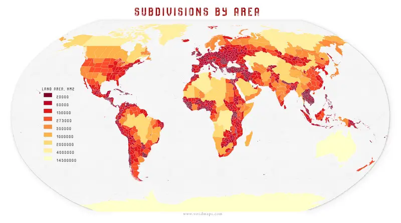
Political maps

Political Maps show governmental and administrative borders of countries, provinces, states, and counties, the location of major cities, and other political units.

Political maps

Governments in Exile Mapped

Governments in exile operate from foreign lands due to conflict or occupation, maintaining their legitimacy and continuing to represent their nations. This post explores their historical roots, key characteristics, and modern examples like the Tibetan and Syrian governments in exile. Learn about their resilience, diplomatic efforts, and the challenges they face in their quest to reclaim their homeland and uphold justice.

Read More
Political maps

U.S. Presidential election 2016: dasymetric dot density

Most election maps mislead by shading entire counties red or blue, but what if we mapped every single vote exactly where people live? This dasymetric dot density map does just that—placing 130+ million dots based on urban, suburban, and rural population densities. The result? A clearer, more accurate picture of the 2016 election. See the real voting patterns emerge! 🔴🔵 Explore the map now.

Read More
Political maps

Current military alliances in the world

A military alliance is an agreement between countries with interesting national security. Nations in a military alliance consent to active participation and assistance to protect others in the alliance in the circumstance of a crisis. If a country is attacked, associates of the alliance are often obligated to come to their defense nonetheless of whether they are attacked presently. There have been approximately 538 military alliance treaties from 1815 to 2003. There have been approximately 538 military alliance treaties from 1815 to 2003.

Read More