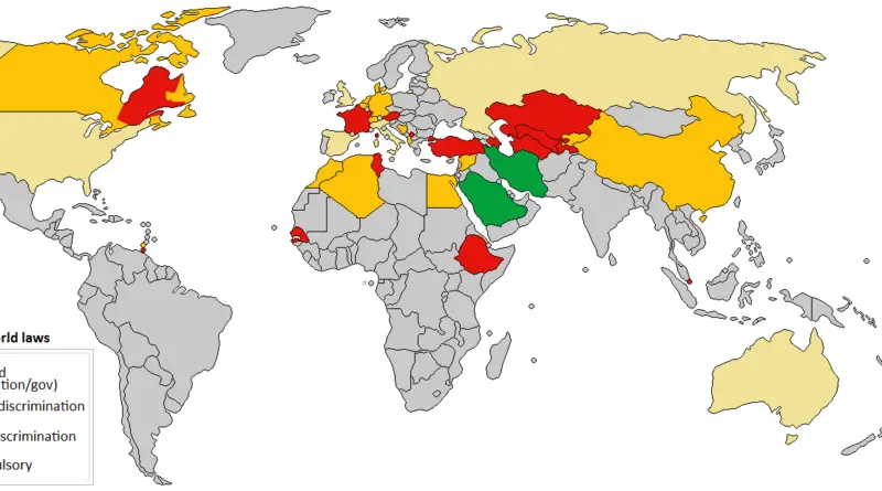
Faithland – Mapping Religion Across America
Explore the religious landscape of the U.S. from 1890 to 2010 through maps I created using ARDA data. See how religion has shaped different areas over time.
Read MoreReligion maps displaying different religions predominating in the world.
Explore the religious landscape of the U.S. from 1890 to 2010 through maps I created using ARDA data. See how religion has shaped different areas over time.
Read MoreA look at the historic divide in Christianity that shaped Europe and beyond. Here’s what happened in 1054—and what often gets left out.
Read MorePopulation density of adherents of religions, 1890 – 2010 Population density of adherents, 2010 Alex Egoshin, www.vividmaps.com Related posts:– Faithland
Read MoreThe group with the second largest number of adherents by U.S. county (1906 – 1910). Youtube Group with the Second
Read MoreCountries that have an official state religion: Christianity – Norway, England, Denmark, Iceland, Greece, Georgia, Vatican, Monaco, Malta, Liechtenstein, Costa Rica, Zambia,
Read MoreGroup with the largest number of adherents by U.S. county (1906 – 1910) The “Other” category includes religious groups with
Read MoreMost Black Protestant counties in America (2010): 1. Bullock County, Alabama – 31.6% 2. Ouachita County, Arkansas – 31.3% 3.
Read MoreEvangelical protestant population
Read MoreMainline protestant population, 1936 – 2010 Mainline Protestant population, 2010 Most Mainline Protestant counties in America (2010): 1. Burke County,
Read MoreOrthodox Christians as a Percentage of all Residents, 1952 – 2010 Orthodox Christians as a Percentage of all Residents, 2010
Read More