The territory of each country is changing through time. Each state in the world has reached its territorial peak, which then ends.
The British Empire had 35.5 million square kilometers under her rule and is the biggest empire ever built. Today Great Britain has a little 0.21 million square kilometers, which brings the ratio between the largest extent and current territory to 0.59 percent. That means that the British lost 99.41 percent of their holdings. Mongols lost 93.6% of their territory, and Spaniards – 96.7%. Also, large territories have lost Turkey (Ottoman Empire), Armenia, and Brunei.
The maps below illustrate how the borders of some countries have changed over the course of history.
In Europe, the Danes controlled Norway, Sweden, Filnaln, Estonia, Iceland, Wessex in southern England.
Reddit user: Ner0x_122
Nowadays, the only lingering remains of the Danish empire and its just substantial land is that of Greenland, whose colonial status stopped in 1953 and is today an autonomous region of the Danish state. The Faroe Islands have had autonomy in Denmark after 1948. Denmark’s overseas territories were obtained in the main peacefully through deals, acquisitions, and trade permissions. Denmark didn’t become entangled in the broader imperial competition among European powers or the Scramble for Africa.
Czechia
The Czechs controlled territories of modern Austria, Slovakia, Poland, and Hungary.
Reddit user: Radiant_Concentrate
The Czech Kingdom or the Kingdom of Bohemia preserved its confirmed status as the separate Kingdom of Bohemia till 1918, recognized as a crown land in the Austro-Hungarian Empire. Following the fall of the Central Powers in WWI, both the Kingdom of Bohemia and Austro-Hungaria were partitioned. The Czech Kingdom became the nucleus part of the lately established Czechoslovak Republic.
Hungary
The Hungarians ruled the territories of Slovakia, Romania, Serbia, Austria, Slovenia, Croatia, Poland, Macedonia, Montenegro, Moldova, Ukraine, Bosnia, and Herzegovina.
The Kingdom of Hungary was a multiethnic state from its inception until the Treaty of Trianon, under which three-quarters of the country were given to the neighboring nations.
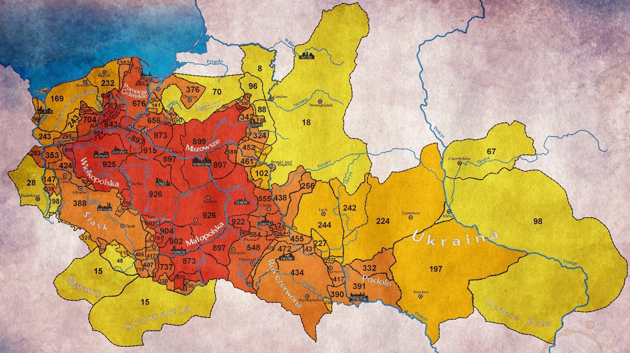
Poland
Poles controlled the Czech Republic, Slovakia, Ukraine, and Belarus.
The Commonwealth of Poland or the Polish–Lithuanian Commonwealth was one of the largest (over one million km2 or 400 thousand mi2 in the area) and most populated countries of Europe in the 16th and 17th centuries.
The First Partition of the Commonwealth of Poland by Prussia, Austria, and Russia took place in 1772. The Second Partition of the Commonwealth of Poland was executed in 1793, which left the nation seized of so much area that it was almost incapable of a sovereign being. In 1795 Poland had split by three of its more powerful neighbors again and discontinued to exist.
The United Kingdom
The British Empire was the largest empire in the history of humankind by total size (35.5 million km2 or 13.71 million mi2. It is about 26.4% of the world area. Since 1708, 166 countries of the world have been part of the British Empire.
Reddit user: LeFedoraKing69
By the beginning of the twentieth century, Germany and the U.S. had started to compete with Great Britain’s financial leadership. Economic and military tautness within Great Britain and Germany were the main reasons for WWI. The war required many military, economic, and human resources. Although the British Empire reached its most significant territorial range directly after WWI, the Empire was no more the global’s leading military and industrial power. During WWII, Great Britain’s colonies in Asia were controlled by the Empire of Japan. Despite the final victory of Britain and its allies, the damage to British prestige helped accelerate the decline of the Empire. India, Empire’s most precious and populous ownership, gained freedom as part of a more significant decolonization process, in which the British Empire gave freedom to most colonies of the Empire. The Suez Crisis proved Great Britain’s weakening as a global power. The transference of Hong Kong to China in 1997 distinguished for many the end of the British Empire, but 14 overseas possessions remain under British control.
Geographical borders throughout a time
Geographic boundaries have changed in the past and continue to change now. The inconstancy of state boundaries between sites is clearly depicted by the map below created by Andres Sundell that shows 1000 years of state borders in Europe overlaid on one map.
A shame about the projection in the U. K. map. Baffin Island looks to be at least the size of India, when India is really about 6 1/2 times bigger.
Chaplin
6 years ago
Seeing the years different places ruled by different nations puts a different perspective on boundaries and border disputes. Check out the link to the years Greece was under Ottoman rule. People who fight over borders lost sight of the big picture. The goal is a peaceful future.


A shame about the projection in the U. K. map. Baffin Island looks to be at least the size of India, when India is really about 6 1/2 times bigger.
Seeing the years different places ruled by different nations puts a different perspective on boundaries and border disputes. Check out the link to the years Greece was under Ottoman rule. People who fight over borders lost sight of the big picture. The goal is a peaceful future.