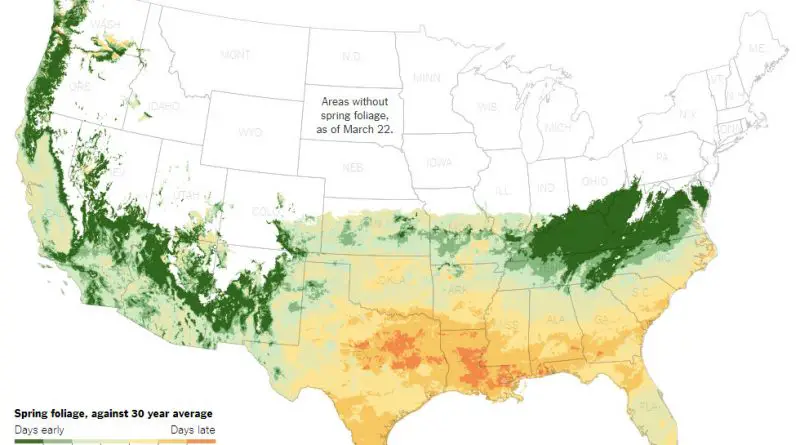
Skip to content
Vivid Maps Logo

  • Atlases
  • Map Posters
  • Scratch Maps
  • Globes
  • Videos
US - Canada border
Size comparison maps
March 2, 2018 Alex

Borders of the United States

The US political borders can be classified into international and internal. An international boundary delineates the space between sovereign nations (Canada-USA-Mexico). Internal boundaries are more bureaucratic and used to break up space into manageable parts of administration.

Read More
Bird Migration
Environment maps
March 1, 2018 Alex

Epic Animal Migrations: How Far Can They Go?

Animals make some of the most incredible journeys on Earth. A falcon flying 10,000 km in 42 days? An Arctic fox walking across sea ice to another continent? Explore these epic migrations through detailed maps and fascinating facts.

Read More
World Map: How Safe Does the World Feel
Crime maps
February 28, 2018 Alex

Who Feels Safe at Night? A Global Look at Safety Perceptions

How safe do people feel walking alone at night? Gallup’s Global Safety Report reveals that global safety perceptions have improved over the past decade — but not everywhere. Find out which countries feel the safest and least safe today.

Read More
The Literal Translation of Country Names
Languages
February 28, 2018 Alex

The Literal Translation of Country Names

Did you know that Canada literally means “The Village” and Ethiopia translates to “Land of Burnt Faces”? Explore these surprising and insightful translations of country names from around the world.

Read More
Population density of Egypt
Population
February 23, 2018 Alex

Why Most Egyptians Live Along the Nile: Egypt’s Uneven Population Density

About 95% of Egypt’s 107 million people live along the Nile and in the delta. Explore maps showing how Egypt’s population density is shaped by the river’s life-giving waters.

Read More
A literal map of the UK
Cultural cartographyHistorical Maps
February 22, 2018 Alex

A “Literal” Map of the United Kingdom

From the Viking-named Shetlands to the Celtic roots of Cornwall, Britain’s county names tell stories of ancient kingdoms and forgotten peoples. This detailed map of the United Kingdom reveals the surprising meanings behind familiar place names and the historical forces that shaped them.

Read More
Education
February 22, 2018 Alex

Where did each country’s head of government obtain their highest educational qualification?

Did you know that most world leaders studied in the U.S., UK, or France? Find out where the world’s current heads of government earned their highest degrees and how it reflects global political influence.

Read More
Mapping Health
February 21, 2018 Alex

Influenza Death Rate by U.S. State

This map shows the influenza death rate across U.S. states from 1999 to 2016. Learn why some states have higher rates and how to protect yourself from the flu.

Read More
U.S. Gerrymandering
Political maps
February 21, 2018 Alex

Gerrymandering: How Political Maps Shape American Elections

Gerrymandering allows politicians to manipulate district boundaries to secure an electoral advantage. Learn how tactics like cracking and packing distort representation and see real examples from Texas, Maryland, and Pennsylvania.

Read More
Climate
February 21, 2018 Alex

Spain’s Latitude Twins: Comparing Climates Across the World

Did you know that Madrid shares a latitude with Cleveland, and Seville aligns with Kuwait? This fascinating map of Spain compares its climate with cities worldwide that share the same latitude.

Read More
Page 115 of 679« First«...102030...113114115116117...120130140...»Last »

Trending now

  • Human phenotypes in Europe
    Human Phenotypes Mapped
  • Decolonisation of Africa mapped
    Atlas of the colonization and decolonization of Africa

Related Products

Push pin maps · Globe drinks cabinets · Maps of the United States · Board games · Monopoly · Map-based strategy board games · History Board Games · Coloring Books · Handheld GPS · GPS Watches · GPS Trackers

Vivid Maps Tools

· Convert Latitude/Longitude
· Elevation Finder
· Distance Calculator
· Kilometers to Miles Converter
· Kilograms to Pounds Converter
· Liters to Gallons Converter
· Temperature Converter
· Antipodes Map
· Find cities with a similar climate
· Find cities with a similar climate (2050)
· How hot cities could be in 2050
· The U.S. Population Lines

About
Privacy Policy

Copyright © 2026 Vivid Maps. All rights reserved.