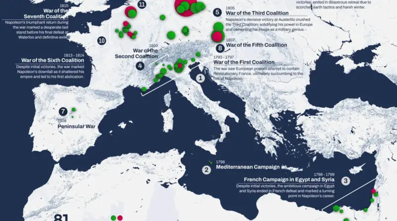
Skip to content
Vivid Maps Logo

  • Atlases
  • Map Posters
  • Scratch Maps
  • Globes
  • Videos
Map of the British Empire colonies
Historical Maps
October 5, 2017 Alex

British Empire at its territorial peak

The British Empire began with England’s overseas settlements and trading posts between the late 16th and early 18th centuries. At its height, it was the largest Empire in history. By 1913 the British Empire covered 35.5 million sq km or 13.7 million sq mi (24% of the planets’ total land area)

Read More
InfographicsMapping StereotypesOld mapsWage
October 5, 2017 Alex

The Reaches of New York City (1939)

“Done in the studios of The National Geographic Magazine The map shows: – Places of interest such as Historic Monuments,

Read More
Animated mapsEthnic mapsSliderVivid maps
October 4, 2017 Alex

The percentage of Jews in the U.S. (1980 – 2010)

Jews as a percentage of all residents, 1980 – 2010 Youtube Jews as a percentage of all residents, 2010 Most

Read More
Economic maps
October 4, 2017 Alex

European countries with economy smaller than Catalonia

Reddit user: eivarXlithuania Catalonia’s nominal GDP: – Total: $255.204 billion – Per capita: $33,580 Catalonia’s GDP (PPP): – Total: $336.162 billion

Read More
Old maps
October 3, 2017 Alex

Plan of the New York City (1776)

Related posts: – New Netherland settlements & areas of influence (1614 – 1674) – Urban Scratchoff – Interactive map of

Read More
Crime maps
October 3, 2017 Alex

The Map of Mass Shootings

729 have been killed since 1982. The two most deadly shootings, Las Vegas (59) and Orlando (49), happened just 16

Read More
Interactive mapsPopulationVivid maps
October 3, 2017 Alex

Population density of United States with United Kingdom equivalents

U.S. states and UK regions, which has a similar population density. Reddit user: trampolinebears Population density of the countries of

Read More
World
October 2, 2017 Alex

A Geographic Perspective of Regions between Decentralisation and Independence

Source: www.viewsoftheworld.net Proportional to population:1. Catalonia (Spain) – 7,504,881 (16%)2. Liverpool/Manchester (UK) – 5,263,555 (8%)3. Scotland (UK) – 5,295,000 (8%)4.

Read More
Political maps
October 2, 2017 Alex

Independence support by region of Catalonia

In blue, Catalan areas where pro-independence parties got more than 50 percent of the vote in the 2015 regional election.

Read More
Animated mapsHistorical MapsSlider
October 2, 2017 Alex

The History of Western Europe from the fall of Rome to modern times.

Read More
Page 142 of 679« First«...102030...140141142143144...150160170...»Last »

Trending now

  • Human phenotypes in Europe
    Human Phenotypes Mapped
  • Decolonisation of Africa mapped
    Atlas of the colonization and decolonization of Africa

Related Products

Push pin maps · Globe drinks cabinets · Maps of the United States · Board games · Monopoly · Map-based strategy board games · History Board Games · Coloring Books · Handheld GPS · GPS Watches · GPS Trackers

Vivid Maps Tools

· Convert Latitude/Longitude
· Elevation Finder
· Distance Calculator
· Kilometers to Miles Converter
· Kilograms to Pounds Converter
· Liters to Gallons Converter
· Temperature Converter
· Antipodes Map
· Find cities with a similar climate
· Find cities with a similar climate (2050)
· How hot cities could be in 2050
· The U.S. Population Lines

About
Privacy Policy

Copyright © 2026 Vivid Maps. All rights reserved.