Skip to content
Vivid Maps Logo

  • Atlases
  • Map Posters
  • Scratch Maps
  • Globes
  • Videos
Political maps
November 9, 2016 Alex

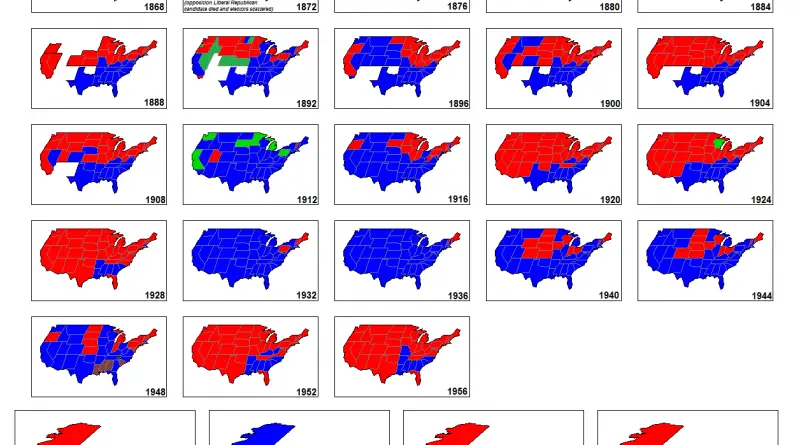
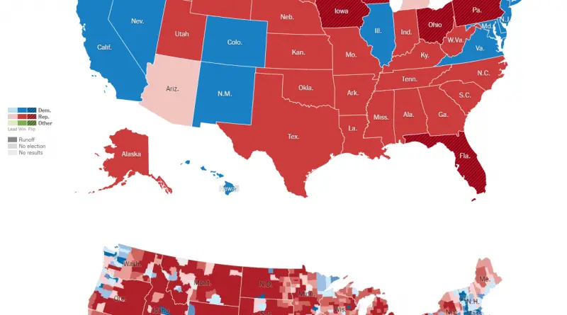
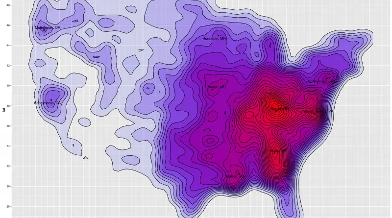
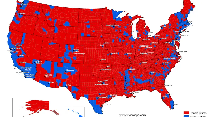
U.S. Presidential Election results and voting populations (2016)

Regular election result map shows who won in which U.S county but didn’t reveal the relative voting populations among each county. It can make people think that every county has an equal population. Moreover, such maps it’s not created to display the margin of victory within each county. It shows who won in a county, even if they won by just one vote.

Read More
Political maps
November 9, 2016 Alex

How the presidential election of 2016 would look like if only millennials voted

STATE DEM % REP % DIFF EV CUSTOM DC 86 4 D+82 3 DC CA 61 18 D+43 55 CA

Read More
Hex mapsMapping StereotypesPolitical maps
November 9, 2016 Alex

Hex map of U.S. electoral votes

Results: Clinton – 218 Trump – 276 Votes: Clinton: 59,163,539 Trump: 59,027,749 Via aljazeera.com Related post: – Electoral Map Upon Trump’s

Read More
Interactive mapsPolitical maps
November 9, 2016 Alex

Searching for issues around voting on Nov 9th

This map shows Google search interest in voting-related issues across the United States at city level. Cities only show up

Read More
Political maps
November 9, 2016 Alex

Every United States presidential elections (1788 – 2016)

Source: unknoun. Paler shade = electors chosen entirely or in part by the state legislature and not, or not wholly,

Read More
Political mapsWars
November 9, 2016 Alex

Electoral Map Upon Trump’s Victory

www.nytimes.com 2016 Presidential Election Results InsideGov | Graphiq Election results where states that neither candidate got the majority of votes

Read More
Ethnic mapsMapping Health
November 8, 2016 Alex

Density map of white mortality rates within the United States

Related posts: – Percentage of white people in the U.S. from 1970 to 2010 – Prevalence of self-reported obesity among

Read More
Mapping StereotypesPopulationTransport
November 8, 2016 Alex

London Corrected

Here’s how central London would look if the Tube map was geographically correct. Via Mapfolder

Read More
Political maps
November 8, 2016 Alex

U.S. Political Donations

www.mapd.com/demos/political-donations/#/dashboard?_k=3d5zxp

Read More
Historical MapsVideoVivid maps
November 8, 2016 Alex

The History of Europe

The History of Europe: Every Year This video maps the entire history of Europe. Some ancient events involve estimated years

Read More
Page 280 of 679« First«...102030...278279280281282...290300310...»Last »

Trending now

  • Human phenotypes in Europe
    Human Phenotypes Mapped
  • Decolonisation of Africa mapped
    Atlas of the colonization and decolonization of Africa

Related Products

Push pin maps · Globe drinks cabinets · Maps of the United States · Board games · Monopoly · Map-based strategy board games · History Board Games · Coloring Books · Handheld GPS · GPS Watches · GPS Trackers

Vivid Maps Tools

· Convert Latitude/Longitude
· Elevation Finder
· Distance Calculator
· Kilometers to Miles Converter
· Kilograms to Pounds Converter
· Liters to Gallons Converter
· Temperature Converter
· Antipodes Map
· Find cities with a similar climate
· Find cities with a similar climate (2050)
· How hot cities could be in 2050
· The U.S. Population Lines

About
Privacy Policy

Copyright © 2026 Vivid Maps. All rights reserved.