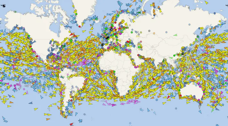
Skip to content
Vivid Maps Logo

  • Atlases
  • Map Posters
  • Scratch Maps
  • Globes
  • Videos
Interactive mapsPolitical maps
March 5, 2016 Alex

Risk Map

Risk Map is a free to use security and risk mapping system; providing a new and unique way of viewing

Read More
Climate ChangeInteractive mapsMediaWorld
March 5, 2016 Alex

World Radio Map

Radioooo – new fun global music map that allows you to listen to music from anywhere in the World and

Read More
ClimateInteractive mapsNOAAWorld
March 5, 2016 Alex

Atmospheric moisture

The atmosphere contains an enormous amount of moisture that circulates around the globe, shown here in this imagery. However, not

Read More
Energy
March 5, 2016 Alex

Electricity to Heat Home

www.metricmaps.org/2016/03/03/electricity-to-heat-home/

Read More
HumanityInteractive mapsWorld
March 4, 2016 Alex

The Intelligence of the Indigenous Peoples

An intelligence quotient (IQ) is a total score derived from one of several standardized tests designed to assess human intelligence.

Read More
ImmigrationInteractive mapsMapping Stereotypes
March 4, 2016 Alex

Where 25,000 Syrians have settled in Canada

Explore the adopted hometowns of 25,000 Syrian refugees who’ve settled in more than 250 communities across Canada. This map visualizes

Read More
Ethnic maps
March 4, 2016 Alex

Neighborhood Racial and Ethnic Change Trajectories (1970 – 2010)

This study sets out to answer the question: how have neighborhoods changed since the Civil Rights Movement outlawed discriminatory housing?

Read More
BusinessMapping StereotypesMaps and AtlasesTravel maps
March 4, 2016 Alex

Iceland (National Geographic Adventure Map)

Let National Geographic’s Iceland Adventure Map guide you as you discover the pristine nature and unique scenery on this Nordic

Read More
DemographyEthnic mapsPopulation
March 4, 2016 Alex

U.S. Population under 5 years of age percent change by county

U.S. Population under 5 years of age percent change by county from 2010 to 2014 U.S. White Non-Hispanic Population under 5

Read More
BusinessDemographyEthnic mapsMapping StereotypesPopulation
March 4, 2016 Alex

U.S. population, percent increase by county

U.S. Population percent change by county from 2010 to 2014 U.S. White Non-Hispanic population, percent increase by county U.S. Hispanic

Read More
Page 430 of 679« First«...102030...428429430431432...440450460...»Last »

Trending now

  • Map of the Roman Empire in the Augustan age
    How Long Did It Take Western Civilization to Map the World?
  • Europea population in 2025 mapped
    When Demographers Tried to Predict 2025… Back in 1990

Related Products

Push pin maps · Globe drinks cabinets · Maps of the United States · Board games · Monopoly · Map-based strategy board games · History Board Games · Coloring Books · Handheld GPS · GPS Watches · GPS Trackers

Vivid Maps Tools

· Convert Latitude/Longitude
· Elevation Finder
· Distance Calculator
· Kilometers to Miles Converter
· Kilograms to Pounds Converter
· Liters to Gallons Converter
· Temperature Converter
· Antipodes Map
· Find cities with a similar climate
· Find cities with a similar climate (2050)
· How hot cities could be in 2050
· The U.S. Population Lines

About
Privacy Policy

Copyright © 2026 Vivid Maps. All rights reserved.