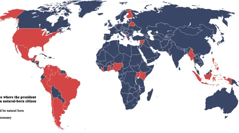
21 maps that explain Russia
What do you know about the largest country in the world? Here is a comprehensive atlas of various maps explaining Russia’s geography, history, politics, and economics.
Read MoreWhat do you know about the largest country in the world? Here is a comprehensive atlas of various maps explaining Russia’s geography, history, politics, and economics.
Read MoreThe most attractive maps of the last year ranked by views. From the largest predator in each U.S. state to tipping etiquette around the world, these marvelous maps show cartography at its best.
Read MoreThe 2020 U.S. presidential election revealed stark contrasts in how Americans vote based on where they live. These original maps show Biden’s urban archipelagos – centers of economic power generating 70% of U.S. GDP – scattered across Trump’s expansive heartland. From county-level analysis to population-weighted visualizations, these maps tell the story of two Americas: one concentrated in high-density cities, another spread across the rural landscape. Building on my viral 2016 electoral maps, this new series offers fresh insights into our nation’s deepening political geography.
Read MoreThe Great Lakes are the most extensive freshwater system globally (94,600 sq mi / 244,000 sq km). The Lakes contain 5,400 cu mi (22,500 cu km) of surface freshwater on earth or 6 quadrillion gallons of freshwater (22.7 quadrillion liters), accounting for about 21% of the world’s surface freshwater or 84% of North America’s surface freshwater.
Using Digital Elevation Model data, I made the map of the Great Lakes in watercolor style.
Read MoreData analyst Alasdair Rae created unique 3D maps of the global population density. This idea inspired me to make three-dimensional maps depicting different climatic parameters. To create these maps, I used Worldclim data: average temperature (°C), precipitation (mm), solar radiation (kJ m-2 day-1), and wind speed (m s-1).
Read MoreEurope’s generational diversity tells a compelling story of cultural transformation. From the post-war Boomers to the digital-native Millennials, each generation brings its unique perspective to the continent’s social and economic fabric.
Read MoreJapan is split into 47 prefectures, making the nation’s first level of administrative and jurisdiction division. They include 43 usual prefectures, two urban prefectures (Osaka and Kyoto), one “territory” (Hokkaido), and one “metropolis” (Tokyo).
Read MoreThe global drone industry is projected to double over the next five years, from $22.5 billion in 2020 to $42.8 billion in 2025. Lawmakers are struggling to keep up with the advancing technology. And while at least 143 nations have enacted some form of drone-related regulation, many experts contend that current drone regulation is lacking to deal with the threat of widespread surveillance.
Read MoreThe first European settlements in America were founded at the beginning of the 17th century. These early settlers created some of the oldest buildings in what would later become the United States of America. However, Homo sapiens first appeared in America about 13,000 years ago.
Read MoreThere is more information about the surface of Mars than there is about the Earth’s seafloor. Only 20% of the ocean floor has so far been mapped in detail.
Read More