CulinaryFoodWorld

The Most Photographed Food in the U.S.

Trover made an in-depth analysis of photos using Google’s Vision A.I. technology. This pre-trained machine learning model identifies various things in pictures, including emotions, writing, and different things, including many types of food and drink. The technology is capable of classifying these objects with a vast range of labels, such as ‘fried food,’ ‘Buffalo wings,’ ‘cocktail,’ and ‘mojito.’

Read more: The Most Photographed Food in the U.S.
Demography

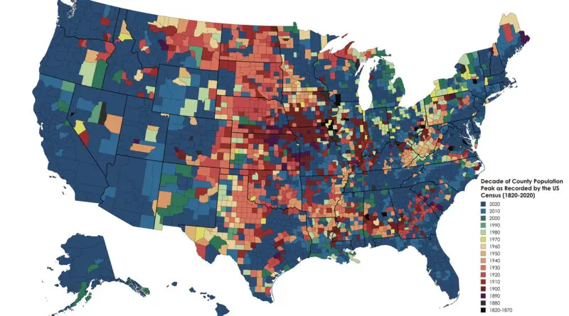
The Decade Every U.S. State and County Peaked in Population

The demographic history of the United States is a rich tapestry woven with diverse threads of immigration, migration, settlement patterns, and socio-economic changes. Since its inception, the U.S. population has experienced dynamic shifts, shaped by various factors such as colonization, westward expansion, industrialization, and globalization.

Read more: The Decade Every U.S. State and County Peaked in Population
Historical MapsOld maps

American victory map of Europe made after the end of WW 1 showing roughly what should be borders of new states

The breakdown of Russia formed Poland, Finland, Estonia, Latvia Lithuania. The Austro-Hungaria separated into Austria, Czechoslovakia, Hungary, and Yugoslavia. The Ottoman Empire lost much of its territory in the Middle East and southwest Asia. Germany lost considerable territories outside Europe.

Read more: American victory map of Europe made after the end of WW 1 showing roughly what should be borders of new states
Historical Maps

Borders proposed by the Count of Aranda in 1782 mapped

Count of Aranda was ambassador to France when the Thirteen Colonies proclaimed their independence from Great Britain, thus kindling the American Revolution. He was involved in drafting the peace treaty that finished the conflict. In addition, his profound knowledge of history placed him ahead of his time, and he predicted the rise of the U.S. as a world power.

Read more: Borders proposed by the Count of Aranda in 1782 mapped