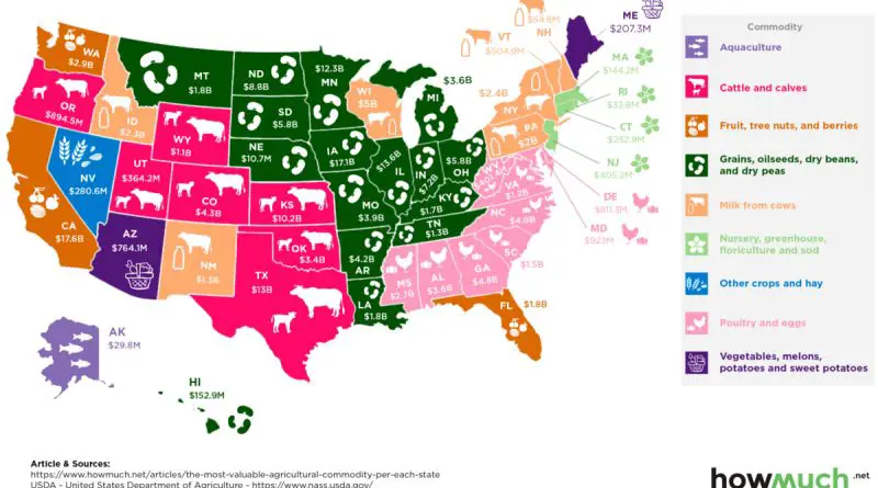
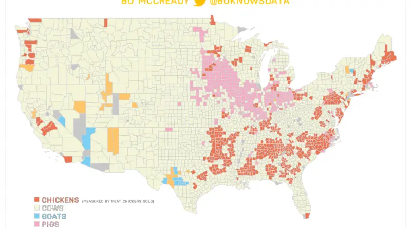
Skip to content
Vivid Maps Logo

  • Atlases
  • Map Posters
  • Scratch Maps
  • Globes
  • Videos
The World’s hundred Largest Islands, Side by Side
Physical maps
February 24, 2019 Alex

The World’s 100 Largest Islands, Side by Side

There are 443 islands in the world that have land areas of 970 square miles (2512 square kilometers) or greater and there are 335 more islands that have land areas of 190 (492 square kilometers) to 969 (2510 square kilometers) square miles.

Read More
The bigges lakes
Physical mapsSize comparison maps
February 24, 2019 Alex

The largest Lakes in the World by Area

According to satelite data there are 117 million lakes to be found worldwide. These lakes covering almost 4% of the world’s land surface.

Read More
Borders between european countries
Political maps
February 21, 2019 Alex

A flag maps of Europe, but each flag is determined on which country they share the longest and shortest border with

The length of state borders in Europe is quite extensive due to the continent’s diverse political landscape and numerous countries. The total length of state borders in Europe was approximately 61,000 kilometers (37,904 miles).

Read More
Map of France
MappingOld maps
February 17, 2019 Alex

Corrected map of France: showing the coastline of France after scientifically mapping it in the late 17th century

In the late 17th century, the mapping of France’s borders was a complex and significant endeavor due to various political, military, and territorial considerations.

Read More
The Average Tax Refund in Every State
Economic maps
February 15, 2019 Alex

Average Tax Refund in Every U.S. State

A tax refund is the amount of money returned to taxpayers by the government when they have paid more taxes than they owe. The size of a tax refund varies depending on various factors, including income, deductions, credits, and individual circumstances.

Read More
How Earth Will look With Current International Borders in 250 million years
Forecasts
February 14, 2019 Alex

How Earth Will look With Current International Borders in 250 million years

Pangaea Ultima (Proxima) could occur within the next 250 million years. The Atlantic and Indian Ocean will continue to get wider until new subduction zones bring the continents back together, forming a Neopangaea. Most continents and islands are predicted to collide with Eurasia.

Read More
The Most Remote U.S. State Capitals
Demography
February 13, 2019 Alex

The Distance of States’ Capitals From Their Centers of Population and Geographical Centers

The location of state capitals in the United States exhibits a variety of geographic patterns and considerations. These patterns can be influenced by historical, economic, political, and geographical factors.

Read More
Protestant Reformation mapped
Maps of World Religions
February 13, 2019 Alex

The Protestant Reformation in Europe at its Peak

The Protestant Reformation profoundly influenced the course of European history, leaving a lasting legacy that continues to shape religious, cultural, and political dynamics to this day.

Read More
How Much You Should Save in Every U.S. State for an Early Retirement
Job
February 12, 2019 Alex

How Much Money You Need To Save To Retire Early In Every U.S. State

Despite being close to retirement age, many Americans have a hard time conceptualizing retirement. Many people are unaware of the amount they require for retirement, let alone early retirement.

Read More
wealthiest and pooriest U.S counties
Economic mapsInfographics
February 12, 2019 Alex

The Wealthiest and Poorest County in Every U.S. State

Loudoun (Va) is the richest county in the United States in terms of median income. It is more than $100,000 higher than Buchanan County, VA, the state’s poorest county at $31,800.

Read More
Page 83 of 679« First«...102030...8182838485...90100110...»Last »

Trending now

  • Human phenotypes in Europe
    Human Phenotypes Mapped
  • Decolonisation of Africa mapped
    Atlas of the colonization and decolonization of Africa

Related Products

Push pin maps · Globe drinks cabinets · Maps of the United States · Board games · Monopoly · Map-based strategy board games · History Board Games · Coloring Books · Handheld GPS · GPS Watches · GPS Trackers

Vivid Maps Tools

· Convert Latitude/Longitude
· Elevation Finder
· Distance Calculator
· Kilometers to Miles Converter
· Kilograms to Pounds Converter
· Liters to Gallons Converter
· Temperature Converter
· Antipodes Map
· Find cities with a similar climate
· Find cities with a similar climate (2050)
· How hot cities could be in 2050
· The U.S. Population Lines

About
Privacy Policy

Copyright © 2026 Vivid Maps. All rights reserved.